127th meridian east
.svg.png)
127°
127th meridian east ()
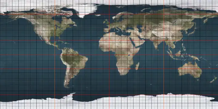
The meridian 127° east of Greenwich is a line of longitude[1] that extends from the North Pole across the Arctic Ocean, Asia, Australia, the Indian Ocean, the Southern Ocean, and Antarctica to the South Pole.
The 127th meridian east forms a great circle with the 53rd meridian west.

From Pole to Pole
Starting at the North Pole and heading south to the South Pole, the 127th meridian east passes through:
Co-ordinates Country, territory or sea Notes 90°0′N 127°0′E / 90.000°N 127.000°E Arctic Ocean 77°34′N 127°0′E / 77.567°N 127.000°E Laptev Sea 73°27′N 127°0′E / 73.450°N 127.000°E  Russia
Sakha Republic — islands of the Lena Delta and the mainland
Amur Oblast — from 55°42′N 127°0′E / 55.700°N 127.000°E51°0′N 127°0′E / 51.000°N 127.000°E  People's Republic of China
Heilongjiang
Jilin — from 45°0′N 127°0′E / 45.000°N 127.000°E
Heilongjiang — for about 10 km from 44°47′N 127°0′E / 44.783°N 127.000°E
Jilin — from 44°43′N 127°0′E / 44.717°N 127.000°E41°45′N 127°0′E / 41.750°N 127.000°E  North Korea
Jagang Province
Yanggang Province
South Hamgyeong Province
South Pyeongan Province
South Hamgyeong Province
Gangwon Province38°13′N 127°0′E / 38.217°N 127.000°E  South Korea
Gyeonggi Province
Passing through Seoul
Gyeonggi Province - Passing through of Suwon
South Chungcheong Province
North Jeolla Province - Passing just west of Jeonju
South Jeolla Province
Passing just east of Gwangju
South Jeolla Province34°18′N 127°0′E / 34.300°N 127.000°E East China Sea Passing just east of the island of Jeju-do, South Korea (at 33°27′N 126°57′E / 33.450°N 126.950°E)
Passing just west of the island of Tonakijima, Okinawa Prefecture, Japan (at 26°22′N 127°8′E / 26.367°N 127.133°E)
Passing just east of the island of Kumejima, Okinawa Prefecture, Japan (at 26°20′N 126°49′E / 26.333°N 126.817°E)
25°45′N 127°0′E / 25.750°N 127.000°E Pacific Ocean Philippine Sea — passing just east of the Talaud Islands,  Indonesia (at 4°16′N 126°55′E / 4.267°N 126.917°E)
4°17′N 127°0′E / 4.283°N 127.000°E Molucca Sea Passing just west of the island of Latalata, Indonesia (at 0°16′S 127°1′E / 0.267°S 127.017°E)
Passing just west of the island of Kasiruta, Indonesia (at 0°26′S 127°5′E / 0.433°S 127.083°E)
1°43′S 127°0′E / 1.717°S 127.000°E Ceram Sea 3°9′S 127°0′E / 3.150°S 127.000°E Indonesia
Island of Buru 3°43′S 127°0′E / 3.717°S 127.000°E Banda Sea Passing just east of the island of Wetar, Indonesia (at 7°43′S 126°50′E / 7.717°S 126.833°E)
Passing just west of the island of Kisar, Indonesia (at 8°2′S 127°8′E / 8.033°S 127.133°E)
8°20′S 127°0′E / 8.333°S 127.000°E  Timor-Leste
8°41′S 127°0′E / 8.683°S 127.000°E Timor Sea 13°46′S 127°0′E / 13.767°S 127.000°E .svg.png) Australia
Australia
Western Australia 32°18′S 127°0′E / 32.300°S 127.000°E Indian Ocean Australian authorities consider this to be part of the Southern Ocean[2][3] 60°0′S 127°0′E / 60.000°S 127.000°E Southern Ocean 66°31′S 127°0′E / 66.517°S 127.000°E Antarctica Australian Antarctic Territory, claimed by Australia
See also
References
- ^ "What is longitude?". oceanservice.noaa.gov. Retrieved 30 June 2025.
- ^ Darby, Andrew (22 December 2003). "Canberra all at sea over position of Southern Ocean". The Age. Archived from the original on 25 December 2018. Retrieved 13 January 2013.
- ^ "Indian Ocean". Encyclopædia Britannica. Archived from the original on 25 December 2018. Retrieved 13 January 2013.
Circles of latitude / meridians | |
|---|---|