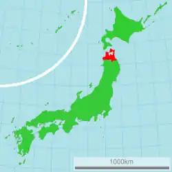
Aomori Prefecture
Aomori Prefecture
青森県 | |
|---|---|
Prefecture | |
| Japanese transcription(s) | |
| • Japanese | 青森県 |
| • Rōmaji | Aomori-ken |
Mount Iwaki and apple blossom Mount Osore Nebuta Oirase River Furofushi Onsen | |
 Flag  Symbol | |
| Anthem: Aomori-ken sanka | |
 | |
| Coordinates: 40°49′29″N 140°44′26″E / 40.82472°N 140.74056°E | |
| Country | Japan |
| Region | Tōhoku |
| Island | Honshu |
| Establishment as part of Mutsu Province | Around 1094 |
| Established as part of Rikuō Province | December 7, 1868 |
| Establishment of Aomori Prefecture | September 4, 1871 |
| Capital | Aomori |
| Subdivisions | List
|
| Government | |
| • Governor | Sōichirō Miyashita |
| Area | |
• Total | 9,645.64 km2 (3,724.20 sq mi) |
| • Rank | 8th |
| Highest elevation (Mount Iwaki) | 1,624.7 m (5,330 ft) |
| Lowest elevation (Pacific Ocean) | 0 m (0 ft) |
| Population (July 1, 2023) | |
• Total | 1,188,043 |
| • Rank | 31st |
| • Density | 120/km2 (320/sq mi) |
| • Dialects | Nanbu・Tsugaru・Shimokita |
| Demonym | Aomorian |
| GDP | |
| • Total | JP¥ 4,533 billion US$ 41.6 billion (2019) |
| ISO 3166 code | JP-02 |
| Longitude | 139°30′ E to 141°41′ E |
| Latitude | 40°12′ N to 41°33′ N[2] |
| Website | www |
| Symbols of Aomori Prefecture | |
| Anthem | Hymn of Aomori Prefecture (青森県賛歌, Aomori-ken sanka) |
| Song | Message of the Blue Forest (青い森のメッセージ, Aoimori no messēji) |
| Bird | Bewick's swan (Cygnus bewickii) |
| Fish | Japanese halibut (Paralichthys olivaceus) |
| Flower | Apple blossom (Malus domestica) |
| Tree | Hiba (Thujopsis dolabrata) |


Aomori Prefecture (青森県, Aomori-ken; Japanese pronunciation: [a.oꜜ.mo.ɾʲi, a.o.mo.ɾʲiꜜ.keɴ]) (hiragana: あおもりけん)[3][4] is a prefecture of Japan in the Tōhoku region. The prefecture's capital, largest city, and namesake is the city of Aomori. Aomori is the northernmost prefecture on Japan's main island, Honshu, and is bordered by the Pacific Ocean to the east, Iwate Prefecture to the southeast, Akita Prefecture to the southwest, the Sea of Japan to the west, and Hokkaido across the Tsugaru Strait to the north. Aomori Prefecture is the 8th-largest prefecture, with an area of 9,645.64 km2 (3,724.20 sq mi), and the 31st-most populous prefecture, with more than 1.18 million people. Mount Iwaki, an active stratovolcano, is the prefecture's highest point, at almost 1,624.7 m (5,330 ft).
Aomori is the third-most populous prefecture in the Tōhoku region. Humans have inhabited the prefecture for at least 15,000 years, and the oldest evidence of pottery in Japan was discovered at the Jōmon period Odai Yamamoto I site. After centuries of rule by the Nanbu and Tsugaru clans, the prefecture was formed out of the northern part of Mutsu Province during the Meiji Restoration. The entire Tōhoku region, including Aomori Prefecture, experienced significant growth in population and economy until the late 20th century, when a significant population decline began. Though the prefecture remains dominated by primary sector industries, especially apple orchards, it also serves as a transportation an logistics hub due to its strategic location at the northern end of Honshu. Additionally, it is also the largest producer of the superfood, black garlic in Japan. Tourism is also a significant part of the prefecture's economy because of its natural beauty and historical sites, especially the Jōmon Prehistoric Sites in Northern Japan and Shirakami-Sanchi World Heritage Sites.
Aomori Prefecture has a distinctive subculture influenced by its location relative to the central government of Japan at the northern edge of Honshu and the region's long, snowy winters. It is the birthplace of the traditional Tsugaru-jamisen, a virtuosic style of playing shamisen. Embroidery, pottery, lacquerware, cabinetry, and iron working are also significant crafts in the prefecture. Various porridges and soups are distinctive to the to area. Several festivals are held in Aomori Prefecture; the most noted of which is Aomori Nebuta Matsuri. The prefecture's most significant writer is novelist Osamu Dazai. Tadamori Ōshima is a politician from the prefecture who held several high level positions in the national government. Aomori Prefecture is home to several association football, baseball, basketball, and ice hockey teams. The prefecture's religious beliefs are heavily rooted in Shinto and Buddhism and has uniqueness in its blind mediums and alleged tomb of Jesus.
History
Aomori literally means blue forest, although it could possibly be translated as "green forest". The name most likely refers to a small forest on a hill which existed near Aomori City, which was often used by fishermen as a landmark.[5][6][7][8]
Jōmon period
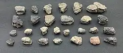
The oldest evidence of pottery in Japan was found at the Odai Yamamoto I site in the town of Sotogahama in the northwestern part of the prefecture. The relics found there suggest that the Jōmon period began about 15,000 years ago.[9] By 7,000 BCE, fishing cultures had developed along the shores of the prefecture which were three metres higher than the present day shoreline.[10] Around 3,900 BCE, the settlement at the Sannai-Maruyama Site in the present-day city of Aomori began.[11] The settlement shows evidence of the wide interaction between the site's inhabitants and people from across Jōmon period Japan, including Hokkaido and Kyushu.[9] The settlement of Sannai-Maruyama ended around 2300 BCE for unknown reasons. Its abandonment was likely due to the population's subsistence economy being unable to result in sustained growth, with its end being spurred on by the reduced amount of natural resources during the neoglaciation.[12] The Jōmon period continued up to 300 BCE in present-day Aomori Prefecture at the Kamegaoka site in the city of Tsugaru where the Shakōkidogū was found.[9]
Yayoi period to Heian period
During the Yayoi period, the area that would become Aomori Prefecture was impacted by the migration of settlers from continental Asia to a lesser extent than the rest of Japan to the south and west of the region. The region, known then as Michinoku, was inhabited by the Emishi. It is not clear if the Emishi were the descendants of the Jōmon people, a group of the Ainu people, or if both the Ainu and Emishi were descended from the Jōmon people. The northernmost tribe of the Emishi that inhabited what would become Aomori Prefecture was known as the Tsugaru.[13] Historic records mention a series of destructive eruptions in 917 from the volcano at Lake Towada. The eruptive activity peaked on August 17th.[14] Throughout the Heian period the Emishi were slowly subdued by the Imperial Court in Kyoto before being incorporated into Mutsu Province by the Northern Fujiwara around 1094.[15] The Northern Fujiwara set up the port settlement Tosaminato in present-day Goshogawara to develop trade between their lands, Kyoto, and continental Asia.[16] The Northern Fujiwara were deposed in 1189 by Minamoto no Yoritomo who would go on to establish the Kamakura shogunate.[17]
Kamakura period
Minamoto no Yoritomo incorporated Mutsu Province into the holdings of the Kamakura shogunate.[18] Nanbu Mitsuyuki was awarded vast estates in Nukanobu District after he had joined Minamoto no Yoritomo at the Battle of Ishibashiyama in 1180 and the conquest of the Northern Fujiwara. Nanbu Mitsuyuki built Shōjujidate Castle in what is now Nanbu, Aomori.[19] The eastern area of the current prefecture was dominated by horse ranches, and the Nanbu grew powerful and wealthy on the supply of warhorses. These horse ranches were fortified stockades, numbered one through nine (Ichinohe through Kunohe), and were awarded to the six sons of Nanbu Mitsuyuki, forming the six main branches of the Nanbu clan.[20][21] The northwestern part of the prefecture was awarded to the Andō clan for their role in driving the Northern Fujiwara out of Tosaminato. The port was expanded under the rule of the Andō clan. They traded heavily with the Ainu in Ezo. However, conflict would break out between the Ainu and the Andō clan in 1268 and again in the 1320s. The conflict was put down after the Nanbu intervened at the behest of the shogunate. The conflict weakened the Kamakura shogunate in its later years, while the Andō were split into northern (Andō) and southern (Akita) divisions.[22]
Muromachi period
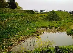
At the onset of the Ashikaga shogunate, the Nanbu and Andō continued to rule the area, with the Nanbu controlling the current prefecture's southeastern section and the Andō controlling the Shimokita and Tsugaru peninsulas. The Andō also were involved with controlling the fringes of Ezo, splitting their attention. In 1336, the Andō completed construction of Horikoshi Castle during the Northern and Southern Courts period.[23] During the Muromachi, the Nanbu slowly began edging the Andō out of present-day Aomori Prefecture. The Andō were pushed out of Tosaminato in 1432, retreating to Ezo, giving the Nanbu control over all their lands. The port settlement would fall into disrepair under the Nanbu.[16]
Sengoku period
During the Sengoku period, the Nanbu clan collapsed into several rival factions. One faction under Ōura Tamenobu asserted their control over the Hirosaki Domain. His clan, originally the Ōura clan (大浦氏, Ōura-shi), was of uncertain origins. According to later Tsugaru clan records, the clan was descended from the noble Fujiwara clan and had an accent claim to ownership of the Tsugaru region on the Tsugaru Peninsula and the area surrounding Mount Iwaki in the northwestern corner of Mutsu Province; however, according to the records of their rivals, the Nanbu clan, clan progenitor Ōura Tamenobu was born as either Nanbu Tamenobu or Kuji Tamenobu, from a minor branch house of the Nanbu and was driven from the clan due to discord with his elder brother.[24] In any event, the Ōura were hereditary vice-district magistrate (郡代補佐, gundai hosa) under the Nanbu clan's local magistrate Ishikawa Takanobu; however, in 1571, Tamenobu attacked and killed Ishikawa and began taking the Nanbu clan's castles in the Tsugaru region one after another.[25] He captured castles at Ishikawa, Daikoji and Aburakawa, and soon gathered support of many former Nanbu retainers in the region. After pledging fealty to Toyotomi Hideyoshi, he was confirmed as an independent warlord in 1590 and changed his name to "Tsugaru", formally establishing the Tsugaru clan. Tsugaru Tamenobu assisted Hideyoshi at the Battle of Odawara, and accompanied his retinue to Hizen during the Korean Expedition. Afterwards, he sided with Tokugawa Ieyasu during the Battle of Sekigahara in 1600.[26]
Edo period
_-_left.jpg)
After the establishment of the Tokugawa Shogunate, the Nanbu ruled the Shimokita Peninsula and the districts immediately to the south of it. The area to the west of the Nanbu's holdings and to the north of the lands held by the Akita clan were all controlled by the Tsugaru clan, from their capital at Hirosaki. Work on Hirosaki Castle was completed in 1611, replacing Horikoshi Castle as the Tsugaru clan's fortress.[23] By 1631, the Tsugaru clan had solidified their control over their gains made during the Sengoku period.[27] Mutsu Province was struck by the Tenmei famine between 1781 and 1789, due to lower than usual temperatures that were exacerbated by volcanic eruptions at Mount Iwaki, near the Tsugaru clan's capital, Hirosaki, between November 1782 and June 1783.[28]
At the beginning of the Edo period, the last pockets of Ainu people in Honshu still lived in the mountainous areas on the peninsulas of the prefecture. They interacted with the ruling clans to some extent, but they primarily lived off of fishing the waters of Mutsu Bay and the Tsugaru Strait. However, the Tsugaru clan made two big pushes to assimilate the Ainu, the first came in 1756 and the second came in 1809. Records show that the clan was successful in wiping out the Ainu culture in their holdings, though some geographic names in Aomori Prefecture still retain their original Ainu names.[29]
Meiji Restoration to World War II
| Year | Pop. | ±% p.a. |
|---|---|---|
| 1880 | 475,413 | — |
| 1890 | 545,026 | +1.38% |
| 1903 | 665,691 | +1.55% |
| 1913 | 764,485 | +1.39% |
| 1920 | 756,454 | −0.15% |
| 1925 | 812,977 | +1.45% |
| 1930 | 879,914 | +1.60% |
| 1935 | 967,129 | +1.91% |
| 1940 | 1,000,509 | +0.68% |
| 1945 | 1,083,250 | +1.60% |
| 1950 | 1,282,867 | +3.44% |
| 1955 | 1,382,523 | +1.51% |
| 1960 | 1,426,606 | +0.63% |
| 1965 | 1,416,591 | −0.14% |
| 1970 | 1,427,520 | +0.15% |
| 1975 | 1,468,646 | +0.57% |
| 1980 | 1,523,907 | +0.74% |
| 1985 | 1,524,448 | +0.01% |
| 1990 | 1,482,873 | −0.55% |
| 1995 | 1,481,663 | −0.02% |
| 2000 | 1,475,728 | −0.08% |
| 2005 | 1,436,657 | −0.54% |
| 2010 | 1,373,339 | −0.90% |
| 2015 | 1,308,649 | −0.96% |
| 2020 | 1,237,984 | −1.10% |
| source:[30][31] | ||
Despite the 1867 resignation of the last shogun, Tokugawa Yoshinobu, the Boshin War had reached northern Japan by late 1868. On September 20, 1868 the pro-Shōgunate Ōuetsu Reppan Dōmei was proclaimed at Morioka, the capital of the Nanbu clan who ruled Morioka Domain. The Tsugaru clan first sided with the pro-imperial forces of Satchō Alliance, and attacked nearby Shōnai Domain.[32][33] However, the Tsugaru soon switched course, and briefly became a member of the Ōuetsu Reppan Dōmei.[34] However, for reasons yet unclear, the Tsugaru backed out of the alliance and re-joined the imperial cause after a few months. The Nanbu and Tsugaru clans resumed their old rivalry and fought at the Battle of Noheji.[32]
As a result of the minor skirmish, the Tsugaru clan was able to prove its defection from the Ōuetsu Reppan Dōmei and loyalty to the imperial cause. Tsugaru forces later joined the imperial army in attacking the Republic of Ezo at the Battle of Hakodate, where the pro-Shōgunate forces were finally defeated.[35] As a result, the entire clan was able to evade the punitive measures taken by the Meiji government on other northern domains.[36]
In 1868, Mutsu Province was broken up into five provinces in the aftermath of the Boshin War, with its namesake province, Rikuō, occupying what would later become Aomori Prefecture and the northwestern corner of Iwate Prefecture.[37] On September 4, 1871, Rikuō Province was abolished and divided, establishing today's Aomori Prefecture. Its capital was briefly located in Hirosaki, but it was moved on September to 23, 1871 the centrally located port village, Aomori.[38]
The prefecture's new capital, Aomori, saw rapid expansion which was due to its importance as a logistic hub in northern Japan.[39] It became a town in 1889 and then a city in 1898. On October 30, 1889, an American merchant ship, the Cheseborough wrecked off the prefecture's west coast near the village Shariki, many of the ship's crew were saved by the villagers.[40] The Nippon Railway, a private company, completed the Tōhoku Main Line in 1891, linking Aomori to Ueno Station in Tokyo.[41] During a military exercise on January 23, 1902, 199 soldiers died after getting lost during a blizzard in the Hakkōda Mountains disaster.[42] On May 3, 1910, a fire broke out in the Yasukata district. Fanned by strong winds, the fire quickly devastated the whole city. The conflagration claimed 26 lives and injured a further 160 residents. It destroyed 5,246 houses and burnt 19 storage sheds and 157 warehouses.[43]
On March 23, 1945, a mudslide destroyed a section of the town of Ajigasawa, killing 87 of its inhabitants.[44] At 10:30 p.m. on July 28, 1945, a squadron of American B-29 bombers bombed over 90% of the city of Aomori. The estimated civilian impact of the air raid on the city was the death of 1,767 people and the destruction of 18,045 homes.[45] Infrastructure was destroyed across the prefecture including the Seikan Ferry, naval facilities in Mutsu and Misawa, Hachinohe Airfield, and the ports and railways of Aomori and Hachinohe.[46][47]
1945 to present
During the Occupation of Japan, Aomori's military bases were controlled by the US military. Hachinohe Airfield was occupied until 1950, and was called Camp Haugen.[48] Misawa Air Base was occupied and rebuilt by the United States Army Air Forces; the base has seen a US military presence since then.[49] Radio Aomori made its first broadcast in 1953.[50] Four years later, the first fish auctions were held. 1958 saw the completion of the Municipal Fish Market as well as the opening of the Citizen's Hospital. In the same year, the Tsugaru Line established a rail connection with the village of Minmaya at the tip of the Tsugaru Peninsula.[51]
In March 1985, after 23 years of labor and a financial investment of 690 billion yen, the Seikan Tunnel finally linked the islands of Honshū and Hokkaido, thereby becoming the longest tunnel of its kind in the world.[52] Almost exactly three years later, on March 13, railroad service was inaugurated on the Tsugaru Kaikyo Line. The tunnel's opening to rail traffic saw the end of the Seikan Ferry rail service. During their 80 years of service, the Seikan rail ferries sailed between Aomori and Hakodate some 720,000 times, carrying 160 million passengers. It continues to operate between the cities, ferrying automobile traffic and passengers rather than trains.[53][54][55]
Aomori Public College opened in April 1993. In April 1995, Aomori Airport began offering regular international air service to Seoul, South Korea, and Khabarovsk, Russia; however, the flights to Khabarovsk were discontinued in 2004.[56] In June 2007, four North Korean defectors reached Aomori Prefecture, after having been at sea for six days, marking the second known case ever where defectors have successfully reached Japan by boat.[57] In March 2011, a magnitude 9.0 earthquake struck the east coast of Japan. The southeastern coast of Aomori Prefecture was affected by the resulting tsunami. Buildings along harbors were damaged along with boats thrown about in the streets.[58][59]
Geography
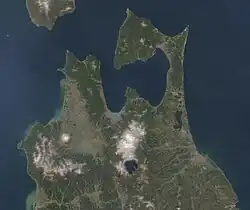
Aomori Prefecture is the northernmost prefecture in the Tōhoku region,[60] lying on the northern end of the island of Honshu. It faces Hokkaido from across the Tsugaru Strait and it borders Akita and Iwate in the south. The prefecture is flanked by the Pacific Ocean to the east and the Sea of Japan to the west with the Tsugaru Strait linking those bodies of water to the north of the prefecture. The islets of Kyūroku-jima in the Sea of Japan are the prefecture's westernmost point.[61] Oma, at the northwestern tip of the axe-shaped Shimokita Peninsula, is the northernmost point of Honshu. The Shimokita and Tsugaru Peninsulas enclose Mutsu Bay. Between those peninsulas lies the smaller Natsudomari Peninsula, the northern end of the Ōu Mountains. The three peninsulas are prominently visible in the prefecture's symbol, a stylized map.[62] Aomori Prefecture is the 8th-largest prefecture, with an area of 9,645.64 km2 (3,724.20 sq mi), and the 31st-most populous prefecture, with more than 1.18 million people.[63] Mount Iwaki, an active stratovolcano, is the prefecture's highest point, at almost 1,624.7 m (5,330 ft).[64][65]
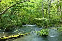
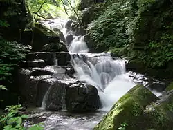
Lake Ogawara, a brackish lake at the base of the Shimokita Peninsula, is the eleventh largest lake in Japan, the largest brackish lake in the Tōhoku area, and the prefecture's largest lake.[66] Lake Towada, a lake that sits in a volcanic caldera, straddles Aomori's boundary with Akita. The lake is a primary feature of Towada-Hachimantai National Park and is the largest caldera lake in Honshu.[67] Also within the park, the Oirase River flows east towards the Pacific Ocean from Lake Towada. Another feature of the park, the Hakkōda Mountains, an expansive volcanic group, rises in the lands to the south of the city of Aomori and north of Lake Towada.[62]
Shirakami-Sanchi, a UNESCO World Heritage Site, is located in the Shirakami Mountains in the western part of the prefecture. The site contains the largest surviving virgin beech forest in East Asia which is home to over 87 species of birds. Mount Iwaki, a stratovolcano and the prefecture's highest point lies to northeast of the Shirakami Mountains. The lands to the east and northeast of Mount Iwaki are an expansive floodplain that is drained by the Iwaki River. Hirosaki, the former capital of the Tsugaru clan, sits on the banks of the river.[62]
As of March 31, 2019, 12% of the total land area of the prefecture was designated as Natural Parks, namely the Towada-Hachimantai and Sanriku Fukkō National Parks; Shimokita Hantō and Tsugaru Quasi-National Parks; and Asamushi-Natsudomari, Ashino Chishōgun, Iwaki Kōgen, Kuroishi Onsenkyō, Nakuidake, Ōwani Ikarigaseki Onsenkyō, and Tsugaru Shirakami Prefectural Natural Parks; and Mount Bonju Prefectural Forest.[68][69]
Cities, towns, and villages
| Rank | Pop. | ||||||||
|---|---|---|---|---|---|---|---|---|---|
| 1 | Aomori | 275,192 | |||||||
| 2 | Hachinohe | 223,415 | |||||||
| 3 | Hirosaki | 168,466 | |||||||
| 4 | Towada | 60,378 | |||||||
| 5 | Mutsu | 54,103 | |||||||
| 6 | Goshogawara | 51,415 | |||||||
| 7 | Misawa | 39,152 | |||||||
| 8 | Kuroishi | 31,946 | |||||||
| 9 | Tsugaru | 30,934 | |||||||
| 10 | Hirakawa | 30,567 | |||||||
Climate
The climate of Aomori Prefecture is relatively cool for the most part. It has four distinct seasons with an average temperature of 10 °C (50 °F). Variations in climate exist between the eastern (Pacific Ocean side) and the western (Sea of Japan side) parts of the prefecture. This is in part due to the Ōu Mountains that run north to south in the middle of the prefecture, dividing the two regions. The western side is subject to heavy monsoons and little sunshine which results in heavy snowfall during the winter. The eastern side is subject to low clouds brought in by northeasterly winds during the summer months, known locally as Yamase winds, from June through August, with temperatures staying relatively low. However, there are instances of Yamase winds making summers so cold that food production is hindered. The lowest recorded temperature during the winter is −9.3 °C (15.3 °F), and the highest recorded temperature during the summer is 33.1 °C (91.6 °F).[62][70] Aomori City and the surrounding areas are known for having the heaviest snowfall in the world.[71] In 2016, AccuWeather ranked Aomori City as the snowiest city in the world.[72]
Temperature comparison
| City | Jan | Feb | Mar | Apr | May | Jun | Jul | Aug | Sep | Oct | Nov | Dec |
|---|---|---|---|---|---|---|---|---|---|---|---|---|
| Aomori[73][74] | 1.8 / −3.5 (35.2 / 25.7) |
2.7 / −3.3 (36.9 / 26.1) |
6.8 / −0.8 (44.2 / 30.6) |
13.7 / 4.1 (56.7 / 39.4) |
18.8 / 9.4 (65.8 / 48.9) |
22.1 / 14.1 (71.8 / 57.4) |
26.0 / 18.6 (78.8 / 65.5) |
27.8 / 20.0 (82.0 / 68.0) |
24.5 / 15.8 (76.1 / 60.4) |
18.3 / 9.1 (64.9 / 48.4) |
11.2 / 3.4 (52.2 / 38.1) |
4.5 / −1.4 (40.1 / 29.5) |
| Hachinohe[75][76][77] | 2.8 / −3.9 (37.0 / 25.0) |
3.6 / −3.7 (38.5 / 25.3) |
7.6 / −0.9 (45.7 / 30.4) |
13.8 / 4.0 (56.8 / 39.2) |
18.7 / 9.2 (65.7 / 48.6) |
21.1 / 13.3 (70.0 / 55.9) |
24.9 / 17.7 (76.8 / 63.9) |
26.5 / 19.5 (79.7 / 67.1) |
23.6 / 15.7 (74.5 / 60.3) |
18.2 / 9.0 (64.8 / 48.2) |
11.9 / 3.0 (53.4 / 37.4) |
5.4 / −1.6 (41.7 / 29.1) |
| Mutsu[78][79][80] | 1.8 / −4.9 (35.2 / 23.2) |
2.4 / −4.9 (36.3 / 23.2) |
6.3 / −2.0 (43.3 / 28.4) |
12.7 / 2.8 (54.9 / 37.0) |
17.8 / 7.8 (64.0 / 46.0) |
20.8 / 12.2 (69.4 / 54.0) |
24.1 / 16.9 (75.4 / 62.4) |
25.8 / 18.4 (78.4 / 65.1) |
23.2 / 14.2 (73.8 / 57.6) |
17.6 / 7.2 (63.7 / 45.0) |
10.9 / 2.1 (51.6 / 35.8) |
4.4 / −2.5 (39.9 / 27.5) |
| Fukaura[81][82] | 2.3 / −2.4 (36.1 / 27.7) |
3.0 / −2.2 (37.4 / 28.0) |
6.7 / 0.1 (44.1 / 32.2) |
12.7 / 4.5 (54.9 / 40.1) |
17.8 / 9.6 (64.0 / 49.3) |
21.6 / 14.1 (70.9 / 57.4) |
25.3 / 18.7 (77.5 / 65.7) |
27.1 / 20.0 (80.8 / 68.0) |
23.6 / 15.9 (74.5 / 60.6) |
17.5 / 10.0 (63.5 / 50.0) |
11.1 / 4.7 (52.0 / 40.5) |
5.1 / −0.3 (41.2 / 31.5) |
| Ōma[83][84][85] | 2.2 / −2.4 (36.0 / 27.7) |
2.7 / −2.3 (36.9 / 27.9) |
6.2 / 0.0 (43.2 / 32.0) |
11.0 / 4.1 (51.8 / 39.4) |
15.0 / 8.5 (59.0 / 47.3) |
18.4 / 12.4 (65.1 / 54.3) |
22.3 / 16.9 (72.1 / 62.4) |
24.8 / 19.1 (76.6 / 66.4) |
22.8 / 16.0 (73.0 / 60.8) |
17.4 / 10.3 (63.3 / 50.5) |
11.0 / 4.8 (51.8 / 40.6) |
4.8 / −0.3 (40.6 / 31.5) |
| Sukayu Onsen[86][87] | −5.1 / −10.0 (22.8 / 14.0) |
−4.3 / −9.8 (24.3 / 14.4) |
−0.2 / −6.8 (31.6 / 19.8) |
6.4 / −0.8 (43.5 / 30.6) |
13.1 / 5.1 (55.6 / 41.2) |
17.6 / 9.8 (63.7 / 49.6) |
21.1 / 14.6 (70.0 / 58.3) |
21.9 / 15.3 (71.4 / 59.5) |
17.7 / 10.7 (63.9 / 51.3) |
11.4 / 4.2 (52.5 / 39.6) |
4.5 / −2.0 (40.1 / 28.4) |
−2.2 / −7.6 (28.0 / 18.3) |
Demographics
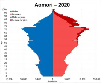
A person living in or from Aomori Prefecture is referred to as an Aomorian.[89] As of 2017, the prefecture had a total population of 1.28 million residents, accounting for just over 1 percent of Japan's total population.[90] Approximately 45 percent of Aomori Prefecture's residents live in its two core cities, Aomori and Hachinohe, which lie on coastal plains.[30] The majority of the prefecture, about 66%, is covered in forested mountain ranges, with population centers occupying valleys and plains.[91] Aomori is the third-most populous prefecture in the Tōhoku region, after Miyagi Prefecture and Fukushima Prefecture.[92]
Population grew in Aomori Prefecture until the late 20th century.[30][31] In 2018, Aomori Prefecture saw the second largest decrease in the number of Japanese citizens out of any prefecture in the country. Only neighboring Akita Prefecture lost more citizens than Aomori.[93] In July 2025 the "Aomori Declaration" was issued by a meeting held in Aomori City of the National Governors' Association to address Japan's declining population, describing it as "the biggest challenge" facing the country.[94] In 2017, 23,529 people moved out of Aomori, while 17,454 people moved to the prefecture.[90] In 2018, about 590,000 of the prefecture's residents were men and 670,000 were women, 10.8 percent of the population was below the age of 15, 56.6 percent of residents were between the ages of 15 and 64, and 32.6 percent was above the age of 64. In the same year the prefecture had a density of 130.9 people per square kilometer. In 2022, the prefecture's birth rate was 1.24, the lowest in recorded history.[95] In 2015, about 3,425 foreign-born immigrants lived in Aomori, making up just 0.26 percent of the prefecture's population, the lowest of any prefecture.[96] Japan is noted for long lifespans, however Aomori Prefecture has the lowest male and female life expectancy of the whole country, for which high salt consumption and low physical activity are factors.[97]
Economy

Like much of the Tōhoku Region, Aomori Prefecture remains dominated by primary sector industries, such as farming, forestry and fishing. The prefecture's forestry industry is centered around the cultivation and harvesting of hiba, a cypress tree utilized in construction of wooden structures across the country.[98] In 2015, its economy had a GDP of 4,541.2 billion yen which made up about 0.83 percent of Japan's economy.[90] Aomori Prefecture generates the largest amount of wind energy out of the prefectures of Japan, with large wind farms located on the Shimokita Peninsula and Tsugaru.[99][100] The peninsula is also home to the inactive Rokkasho Reprocessing Plant that is owned by Japan Nuclear Fuel Limited, a company headquartered in the village of Rokkasho that is involved in the production of nuclear fuel, as well as the reprocessing, storage, and disposal of nuclear waste.[101] In July 2024, the governor of Aomori announced the approval of a nuclear waste storage facility in town of Mutsu.[102] The city of Hachinohe is home to the Pacific Metals Company, a manufacturer of ferronickel products.[62]
Agriculture
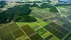
Aomori Prefecture is a leading agricultural region in Japan. It is Japan's largest producer of apples, accounting for 59 percent of Japan's total apple production in 2018.[103] The cultivation of apples in the prefecture began in 1875 when the prefecture was given three varieties of western origin to grow. Most imported apple trees came from the United States and France.[104] The apples are consumed within Japan and exported to the United States, China, Taiwan, and Thailand.[62] Aomori is also ranked highly in the nation's production of redcurrant, burdock, and garlic, accounting for 81, 37, and 66 percent, respectively, of the country's production.[103]
Aomori also boasts being the home to Hakkōda cattle, a rare, region-specific breed of Japanese Shorthorn.[105] The town of Gonohe has a long history as a breeding center for horses of exceptional quality, popular among the samurai. With the decline of the samurai, Gonohe's horses continued to be bred for their meat. The lean horse meat is coveted as a delicacy, especially when served in its raw form, known as basashi (馬刺し). The Aomori coast along Mutsu Bay is a large source of scallops, but they are particularly a specialty of the town Hiranai where the calm water around Natsudomari Peninsula makes a good home for them.[106]
Tourism
Tourism has been a growing sector of Aomori Prefecture's economy. It was among the top five prefectures of Japan in terms of growth in foreign tourists between 2012 and 2017.[108] This influx of foreign tourists has led to the construction of more hotels in Aomori.[108] Major draws to the prefecture are its historic sites, museums, and national parks. Several of the prefecture's Jōmon period historic sites were nominated in January 2009 to become UNESCO World Heritage Sites and were placed on the World Heritage Tentative List.[109] On July 27, 2021 the other Jōmon sites, totalling 17 sites, in neighboring prefectures were placed on the World Heritage Site list.[110][111] These sites were the second sites in Aomori Prefecture placed on the list. The first was Shirakami-Sanchi, an area of virgin forests. Tourist access to Shirakami-Sanchi is heavily restricted due to its delicate ecosystem, though several water features, trails, and roads can be accessed by its visitors.[112][113] About 35.2 million domestic travellers visited Aomori Prefecture in 2016, while about 95,000 foreign tourists visited in 2017.[90]
Military
Aomori Prefecture and the Tsugaru Strait are of strategic value to both Japan and the United States, as the strait serves as an access point for the United States Navy into the Sea of Japan where they can put pressure on Russia, China, and North Korea.[114] The prefecture also hosts Misawa Air Base, the only combined, joint U.S. service installation in the western Pacific servicing Army, Navy, Marine Corps, Space Force, and Air Force, as well as the Japan Self-Defense Forces.[115] The JSDF maintains bases across the prefecture including, JMSDF Ōminato Base, JMSDF Hachinohe Air Base,[116] and JGSDF Camp Aomori.[117]
Culture
Traditional crafts
.jpg)
The Tsugaru region of Aomori Prefecture is the birthplace of the traditional Tsugaru-jamisen, a virtuosic style of playing shamisen that is deeply entwined with the region's identity and history. A notable player of the style was Takahashi Chikuzan, a blind musician from Hiranai who wandered around the country and eventually gained nationwide appeal.[118][119] Aomori Prefecture is also where the decorative embroidery styles, kogin-zashi and Nanbu hishizashi originated as more utilitarian textile techniques during the Edo period. The peasant women of the area, who created the styles, used them to make linen clothing more robust and warm during the harsh winters since cotton was unavailable to the lower class.[120][121] [122][123] Wooden horse figures called Yawata-uma (also Hachinohe horse), have been made in the former holdings of the Nanbu for 700 years.[124] Hachinohe horses are often given at celebrations as they are believed to bring good luck.[125] Other crafts native to Aomori Prefecture include pottery, lacquerware, cabinetry, and iron working.[126][127] The type of lacquerware specific to Aomori is known as Tsugaru-Nuri.[128]
Cuisine

The Aomori area has given rise to several soups: ke porridge or Keno-jiru, which consists of miso soup with diced root vegetables and wild plants such as butterbur and bracken with tofu from the Tsugaru area; ichigoni, a sea urchin roe and abalone soup in which the sea urchin roe looks like strawberries, known as ichigo in Japanese, from the town of Hashikami; hittsumi a roux with chicken and vegetables from the Nanbu area; Hachinohe senbei soup a hearty soup with Nanbu senbei loaded with vegetables and chicken; jappa-jiru a vegetable soup with cod roe from Aomori; and keiran a red bean dumpling soy sauce soup served during special occasions on the Shimokita Peninsula. Another dish that was created in the area surrounding Mutsu Bay is kaiya in the Tsugaru area or kayaki on the Shimokita Peninsula, it is a boiled miso and egg dish mixed with fish or scallop meat on a large scallop shell that serves as both the cookware and serveware.[129] In 2006, the production of aged black garlic began in Aomori Prefecture. The prefecture has since become the largest producer of the superfood in Japan.[130]
Festivals
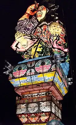
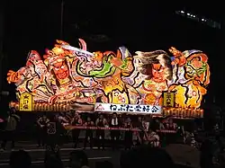
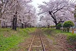
Aomori Prefecture boasts a variety of festivals year round offering a unique look into northern Japan, and hosts the Aomori Nebuta Matsuri, one of the Three Great Festivals of Tōhoku. The other two Great Festivals are Akita Kanto and the Sendai Tanabata, which are held elsewhere in Tōhoku.[131] During late April hanami festivals are held across the prefecture, with the most prominent of the festivals being located on the grounds of Hirosaki Castle.[132][133] Summer and autumn hold many distinct festivals with bright lights, floats, dancing and music.[134] Winter is centered on snow festivals where attendees can view ice sculptures and enjoy local cuisine inside an ice hut.[135][136]
Arts and literature
Aomori Prefecture has produced several writers and artists. Osamu Dazai, the writer of Japan's second most popular novel No Longer Human,[137] is one of the prefecture's best-known writers.[138] Shunsuke Kikuchi, a composer for series such as Dragon Ball and Doraemon, was born in the city of Hirosaki.[139] The creator of the supernatural manga series Shaman King, Hiroyuki Takei, is from the village of Yomogita in northwestern Aomori.[140] The comedian Daimaō Kosaka, known widely for his viral single "PPAP (Pen-Pineapple-Apple-Pen)", was born in Aomori Prefecture.[141] Sōsaku-hanga artist Shikō Munakata was born in Aomori.[142] Much of his art was inspired by the prefecture's natural qualities and rural culture.[143]
Religion

Japanese religious beliefs are very syncretic,[144] known as Shinbutsu-shūgō. Shinbutsu bunri, the formal separation of Buddhism and Shintoism, together about 95% of the population, didn't occur until the late 19th century.[145] This began occurring during the Meiji Restoration when a series of law began to be passed. There is no agreement as to the degree of melding of the two religions.[146] Christianity comprises only about 1-2% of the population of Japan.[147] However, the Christian population is concentrated mostly in Tokyo and western Japan.[148] In Aomori Prefecture Christians are less than 1% of the population.[149]
The Takayama Inari Shrine is a Shinto shrine located in Tsugaru. The shire is noted for prayers on behalf of business prosperity, plentiful harvests, and maritime safety. There is a memorial with a Christian cross dedicated to American sailors who died when the Cheseborough ran aground in a typhooon at Shariki, Aomori (later merged into Tsugaru), in 1889.[150][151]
Mount Osore, located on the Shimokita Peninsula of the prefecture, is covered with a barren landscape, jagged rock formations, and smells of sulphuric gases. It is considered a gateway to the underworld. The Bodai-ji Temple is located here and it specializes in taking care of the dead and is the traditional home to the itako blind mediums who connect with the dead.[152][153]
Blind mediums
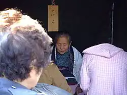
Itako, also known as ichiko or ogamisama, are blind women who train to become spiritual mediums in Japan.[154] They are strongly associated with Aomori Prefecture and today they are most commonly associated with Mt. Osore area of the prefecture. Itako have traditionally gathered there for an annual festival to channel the dead for thousands of tourists.[155] Itako perform ceremonies to communicate with spirits of the recently deceased,[156] including those of aborted and stillborn children.[157]
The tradition of itako arose because in earlier times the prefecture had very poor nutrition and sanitation, causing many children to go blind. In order for these children to be able to make a living, the females were trained as itako and the males for professions such as acupuncture, massage, moxibustion, and playing shamisen.[157][158] Blindness has long been associated with spiritual powers in Japan.[159] The Japanese are also very eclectic in their religious beliefs, incorporating animism -- including kami, a belief in the power of mountains, Buddhism, Shintō, Confucianism, and other beliefs. This all resulted in the rise of itako.[158]
Training involves severe ascetic practices, after which the woman is said to be able to communicate with Japanese Shinto spirits, kami, and the spirits of the dead.[156] Itako perform rituals tied to communication with the dead[156] and divination.[160] In the 1950s-1970s there were still dozens of itako in the prefecture.[158] The practice has been on the decline since then. As of 2009, there were only 20 living itako in Japan, all more than 40 years old.[154]
Training for itako traditionally began at a very young age, and included ritualized exposure to cold water. Hundreds of buckets of ice water could be poured on their bodies over the course of a few days.[156] This education for itako takes about three years, and also includes memorization of songs and sutras.[161] At the end of this training, a ceremony is held, announcing the marriage of the itako and her patron spirit.[162]
Tomb of Christ
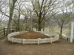
In what is widely believed to be a hoax, documents were found in 1935 claiming Jesus preached and died at age 106 in Shingō village in Aomori Prefecture.[a] The documents, known as the "Takeuchi manuscript" or "Takeuchi documents",[164] claim Jesus did not die on the cross, but rather his brother did and Jesus made his way to Aomori via Siberia. Jesus then married a young woman named Miyuko and fathered three daughters.[165] During this time he trained for 12 years and then began to spread Christianity. His alleged grave is in Shingō and 20,000-30,000 thousand visitors see it every year. In June 1964 an annual festival began being held at the gravesite.[163][164][166] Jesus' eldest alleged daughter married into the Sawaguchi family and there are still members of that family who claim non-Asian physical characteristics and lineage from Jesus.[165]
Landmarks
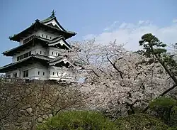
Hirosaki Castle was the seat of the Tsugaru clan that was constructed in 1611. It is the only castle in the Tōhoku region from the Edo period that is still standing and is located in the western part of the prefecture. The Japan Castle Foundation lists it as one of the "100 Fine Castles of Japan." Festivals held here include: the Snow Lantern Festival, Hirosaki Cherry Blossom Festival, and Hirosaki Neputa Festival.[133][167]
The Sannai-Maruyama Site is an early-late middle Jōmon period site where thousands of artifacts have been found here. It is located in Sannai, Aomori City.[11][168] It was designated as a Special National Historical Site of Japan in 2000,[169] and a UNESCO World Heritage Site as part of the Jōmon Prehistoric Sites in Northern Japan collection in 2021.[170][171] The site has various reconstructions of Jōmon structures, and a museum that displays and houses artifacts collected on the site, which have collectively been designated an Important Cultural Property of Japan.[172]
Osamu Dazai Memorial Museum, also known as Shayōkan, is a museum that was formerly a writer's home built in 1907 located in Kanagi area of Goshogawara.[173] While consisting mostly of Japanese style architecture, there are also Westen influences, such as the staircase. It is an Important Cultural Property of Japan.[174]
The Aomori Museum of Art is located near the Sannai-Maruyama Site, which inspired the museum's partially buried structure.[175] It opened in 2006 focusing on highlighting the arts of northern Tōhoku. An 8.5 metres (28 ft) tall concrete scuplture of a dog has become the museum's symbol.[176] The Towada Art Center is a set of geometric structures designed by SANAA and opened in 2008 in an effort to revitalize downtown Towada. It focuses on art that blends city structures and nature. Some of the works it holds are by Ron Mueck and Yoko Ono.[177]
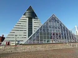
The Aomori Prefecture Tourist Center, also known as Aomori Prefecture Tourism Information Center (ASPAM - “Aomori” “Sightseeing” “Products” “Mansion.”), is large triangle shaped building built in 1986 in Aomori City used to promote tourism in the prefecture. It has a 360-degree panoramic movie theater, a Kogin-zashi embroidery demonstration, apple sales, and an observatory.[178]
Sports
The two largest cities of the prefecture, Aomori and Hachinohe, both host professional sports teams. Both cities have professional soccer clubs in the Japan Professional Football League: Aomori's ReinMeer Aomori and Hachinohe's Vanraure Hachinohe. Other professional sports teams in the two cities include the Aomori Wat's, a basketball team from Aomori in the B.League and the Tohoku Free Blades, an ice hockey team from Hachinohe that competes in the Asia League.[179][180] Aomori Prefecture hosted the 2003 Asian Winter Games from February 1-8, 2003.[181] Approximately 1,200 athletes from 29 Asian countries participated in the games. Five venues across the prefecture held 51 different events.[182] Aomori Prefecture is slated to host the 80th National Sports Festival of Japan in 2026.[183] Aomori was slated to host these games in 2025, but due to COVID-19 pandemic the host prefectures were delayed for a year.[184][185] The prefecture has produced some professional athletes. Yoshisada Yonezuka from the town of Nakadomari was a martial arts instructor for USA Judo.[186] He coached the team in the 1988 and 1992 Summer Olympics.[187] Several ice hockey players are from Aomori, such as Masami Tanabu, who later became a politician,[188][189] and Fumika Sasano.[190]
Major professional teams
| Club | Sport | League | Stadium and city |
|---|---|---|---|
| Aomori Wat's | Basketball | B.League (East Second Division) | Maeda Arena, Aomori[191] |
| ReinMeer Aomori | Association football | Japan Football League (JFL) | Maeda Arena, Aomori[192] |
| Tohoku Free Blades | Ice hockey | Asia League Ice Hockey | Flat Arena, Hachinohe[193] |
| Vanraure Hachinohe | Association football | Japan Professional Football League (J3 League) | Prifoods Stadium, Hachinohe[194] |
Minor professional and amateur teams
| Club | Sport | League | Stadium and city |
|---|---|---|---|
| Blancdieu Hirosaki FC | Association football | Tohoku Soccer League (Division 1) | Hirosaki Sports Park, Hirosaki[195] |
| Hachinohe Reds | Ice hockey | Japan Women's Ice Hockey League | Tanabu Ice Hockey Arena, Hachinohe[196] |
| Hirosaki Areds | Baseball | Japan Amateur Baseball Association | Hirosaki[197] |
| King Blizzard | Baseball | Japan Amateur Baseball Association | Goshogawara[197] |
Other teams
The Aomori Curling Club was a curling club of the Japan Curling Association from the city of Aomori that represented Japan in the 2006 Winter Olympics and the 2010 Winter Olympics and several World Curling Championships. The club was disbanded in 2013.[198]
Government
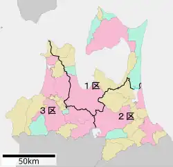
Aomori Prefecture's head of government is a governor with the seat of the prefectural government in the city of Aomori.[199] There are 48 members in the Aomori Prefectural Assembly, which is unicameral. Members are elected to 4-year terms.[200] In terms of national politics, the prefecture has three single-member districts: Aomori 1st district, Aomori 2nd district, Aomori 3rd district, each a constituency of the House of Representatives in the national Diet of Japan.[63][201] In addition, the prefecture has two members elected from the Aomori at-large district to the House of Councillors in the Diet. The at-large members are elected in staggered every 3-year elections for six year terms.[202][203] Aomori Prefecture is traditionally a stronghold of Japan's Liberal Democratic Party (LDP), though the Constitutional Democratic Party of Japan (CDP) has won some elections since its formation in 2017.[202][203][204] One of Aomori Prefecture's notable polilticians is LDP member Tadamori Ōshima, who served as the Minister of Education, Culture, Sports, Science and Technology (2000-2002), Minister of Agriculture, Forestry and Fisheries (2002-2003), and Speaker of the House of Representatives of Japan (2015-2021). He also held several leadership positions in the LDP.[205][206][207]
Education

Aomori Prefecture's national university is Hirosaki University, which was formed by the combination of several colleges and higher education schools in 1949 in accordance with the National School Establishment Law of 1949.[208] The prefecture has two other public universities, Aomori Public University and the Aomori University of Health and Welfare. Several private universities are also located in Aomori Prefecture. Among them are Aomori University, Hachinohe Gakuin University, Hachinohe Institute of Technology, Hirosaki Gakuin University, Hirosaki University of Health and Welfare, Tohoku Women's College, and the Towada Campus of Kitasato University.[209]
The Aomori Prefecture Board of Education oversees various aspects of the prefecture's educational system including the management of libraries, the Aomori Prefectural Museum, and various educational support offices and centers. In all, the prefecture allocated 130.3 billion yen towards education in 2018. In 2017 the prefecture's public school system was teaching 133,507 primary and secondary students, a sharp decrease from a total of 173,537 students ten years earlier. Overall the prefecture has 94 kindergartens (1 of which is a national school and 3 that are public), 289 elementary schools (1 of which is a national school and 288 that are run by municipal governments), 161 middle schools (1 of which is a national school, another which is run by the prefecture, 4 that are private, and 155 that are run by municipal governments), and 95 high schools.[210]
Transportation
Aomori Prefecture has 20,606.8 km (12,804.5 mi) of roads, highways, and streets, along with 227 km (141 mi) of expressways.[211][212] Four major expressways pass through the prefecture: the Tōhoku Expressway, which runs south–north through center of the prefecture; the incomplete Tsugaru Expressway, running east–west in the southwestern portion of the prefecture; the partially-complete Hachinohe-Kuji Expressway that travels south–north along the prefecture's eastern coast to Hachinohe; and the partially-complete Shimokita Expressway that travels south–north along Shimokita Peninsula from the town of Noheji to the city of Mutsu.[212]
Several auxiliary routes of the Tōhoku Expressway also serve the prefecture. The Aomori Expressway and Hachinohe Expressway, spur routes into the eastern part of the city Aomori and central Hachinohe. A spur of the Hachinohe Expressway continues northwest across the eastern side of the prefecture towards the prefecture's capital. It is made up of several named routes: the Momoishi Toll Road, the Daini-Michinoku Toll Road, the Kamikita Expressway, and the Michinoku Toll Road.[213] Several national highways pass through the prefecture. National routes 4, 7, and 45 are primary routes that link the prefectural capital to the capitals of other prefectures across Japan. Additional national routes in Aomori Prefecture include routes 101, 102, 103, 104, 279, 280, 282, 338, 339, 340, 394, and 454. Two of the prefecture's national highways also continue north across the Tsugaru Strait to Hokkaido: National Route 279, which is carried to Hakodate by the Tsugaru Kaikyō Ferry; and National Route 280, which was previously carried by ferry to the town of Fukushima, Hokkaido, though the route is still signed from Fukushima to Hakodate.[214]
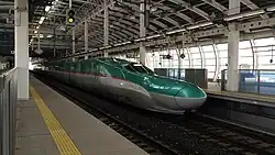
Railways have played an important role in Aomori Prefecture's transportation network and development since the Meiji period. Aomori Station, Shin-Aomori Station, Hachinohe Station, Hirosaki Station, and Shichinohe-Towada Station are major rail stations operating in Aomori Prefecture.[215] The East Japan Railway Company (JR East), operates several rail lines in the prefecture: the Tōhoku Shinkansen, the Tōhoku Main Line, the Ōu Main Line, the Ōminato Line, the Gonō Line, the Hachinohe Line, and the Tsugaru Line. Other notable rail operators in the prefecture are the Hokkaido Railway Company (JR Hokkaido), that runs the Hokkaido Shinkansen through the Seikan Tunnel to and from Hokkaido, the Aoimori Railway that operates passenger services on the Tōhoku Main Line,[213] and the northernmost privately owned railway in Japan, the Tsugaru Railway.[216]
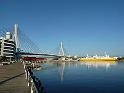
Maritime transport in Aomori Prefecture operates primarily from the ports of Aomori, Mutsuogawara, and Hachinohe, though smaller ports are found throughout the prefecture.[217] The ports at Aomori and Hachinohe both serve cruise ships and ferry lines.[218] Additionally, a ferry line operates between Ōma and Hakodate.[219] Prior to the opening of the Seikan Tunnel, rail ferries operated by the Japanese National Railways linked Aomori Station and Hakodate Station as the primary connection between Hokkaido and the rest of Japan. A museum dedicated to the historic rail ferries operates near Aomori Station in a former rail ferryboat, the Hakkoda Maru.[220]
There are two commercial airports located within Aomori Prefecture, Aomori Airport and Misawa Airport.[221] Both airports are relatively small, though Aomori Airport offers regular international flights to South Korea and Taiwan, in addition to domestic flights to several cities.[222]
Symbols and names
During the Lowell Observatory Near-Earth-Object Search conducted in Flagstaff, Arizona for main-belt asteroids that have a risk of coming close to Earth,[223] observers discovered 19701 Aomori, an asteroid which they named after Aomori Prefecture. 19701 Aomori was given its name on May 9, 2012 after the 2011 Tōhoku earthquake and tsunami to pay respect towards the damaged communities along the prefecture's southeastern coast.[224]
Prefectural symbols
Since 1961, the prefectural symbol of Aomori is a green stylized map of the prefecture on a white background, showing the crown of Honshū: the Tsugaru, Natsudomari and Shimokita Peninsulas. The green is representative of development while the white symbolizes the vastness of the world.[225]
The prefectural bird has been Bewick's swan since 1964, the species migrates to the area during the winter. In 1966, the prefecture designated the hiba (Thujopsis dolabrata) as its prefectural tree. The apple blossom was designated as the prefectural flower in 1971 to pay homage to the prefecture's apple production. In 1987, the Japanese halibut was designated as the prefectural fish.[225]
Dialects
Tōhoku dialect, one of the three main dialects of Japan, is spoken in Aomori Prefecture. The most widespread variants are the Tsugaru dialect, Nanbu dialect, and Shimokita dialect. The boundary determining which of these dialects are spoken is mainly along the former border of the Tsugaru and Nanbu clans between Hiranai and Noheji, with some overlap.[226] Speakers of the Tsugaru dialect are typically centered around Hirosaki, while those who use the Nanbu dialect are centered around Hachinohe.[227] The Shimokita dialect is used on the Shimokita Peninsula around Mutsu and has been recognized as having enough differences to distinguish it from the Nanbu dialect.[228] It was also used in combination with the Nanbu dialect in an early Japanese–Russian dictionary written by a man whose father came from the Shimokita Peninsula.[229]
The oldest discovered compilation of words and phrases of the Nanbu dialect was written in 1790 followed by a dictionary of the Tsugaru dialect in 1809.[230] Special features of the Aomori dialects include an atypical intonation,[231] voicing consonants that are typically unvoiced (e.g. [k] sounds become [g]),[232] and the addition of voiced velar nasal sounds and corresponding kana (か゚ [ŋa], き゚ [ŋi], く゚ [ŋu], け゚ [ŋe], and こ゚ [ŋo]).[233]
There is a negative connotation that surrounds people who speak this dialect, labeling them as lazy country folks. Due to this negativity speakers of Tōhoku dialects will often hide their accents.[234] A study performed in 2016 indicated that people from Aomori who are 70 years and older frequently use these dialects, while use becomes less frequent the younger a person is regardless of fluency.[235] Additionally, the study revealed that when traveling to Tokyo, older generations will continue to use their dialect, while younger generations switch to standard Japanese. On the other hand, over half of each generation surveyed preferred to use their local dialect when talking to Tokyoites in Aomori Prefecture.[236] In the Tōhoku region since the 1980s, more standard Japanese language is widely used by those born since the 1980s. However, dialectal forms are more common in the Tsugaru region of Aomori Prefecture. Southern Tōhoku reveals a transition from standard language to dialects fo Aomori Prefecture.[237]
Media
The largest newspaper by readership in Aomori Prefecture is The Tōō Nippō Press with a daily readership of 245,000, 56% of the total share of the newspaper market in the prefecture.[238] The newspaper also runs a radio news station which is broadcast by the Aomori Broadcasting Corporation (RAB).[239] Other local newspapers are Hachinohe's The Daily Tōhoku Shimbun,[240] Hirosaki's Mutsu Shimpo,[241] and Kuroishi's Tsugaru Shinpō.[242]
Four television stations are broadcast in Aomori Prefecture. RAB is a television and radio broadcaster based in the capital that is affiliated with the Japan Radio Network, National Radio Network, and Nippon News Network. RAB uses the call signs JOGR-DTV for digital television broadcasts and JOGE, JOGO, and JOGR for radio broadcasts in Hirosaki, Hachinohe, and Aomori, respectively. Japan News Network's affiliate, Aomori Television began broadcasting with the call sign JOAI on 1 December 1969. Asahi Broadcasting Aomori. NHK broadcasts radio, television, and digital television from NHK Aomori with the call signs JOTC and JOTG. NHK radio services began on April 17, 1941, while television broadcasts commenced on 22 March 1959.[50]
Hani Motoko, a native of Hachinohe, is considered to be Japan's first female journalist. She became known for her column about famous Japanese women that began publication in 1897 in the Hōchi Shimbun. Motoko later started a journal, that focused on the values of middle-class women.[243]
Notable people from Aomori Prefecture


- Takahashi Chikuzan, musician[119]
- Osamu Dazai, author[138]
- Miki Furukawa, musician, and former bass guitarist and singer for the Japanese rock band Supercar[244]
- Nitta Hachirō, singer of popular and classical music from the early Shōwa era.[245]
- Miki Hanada, nurse[246]
- Junji Ishiwatari, musician, and former guitarist and songwriter for the Japanese rock band Supercar[244]
- Shunsuke Kikuchi, composer[139]
- Daimaō Kosaka, comedian known widely for his single "PPAP (Pen-Pineapple-Apple-Pen)"[141]
- Kenichi Matsuyama, actor[247]
- Hani Motoko, journalist[243]
- Shikō Munakata, artist and the recipient of the 1970 Order of Culture[142]
- Koji Nakamura, musician, and former guitarist and lead singer for the Japanese rock band Supercar[244]
- Yoshie Shiratori, escape artist[248]
- Shuji Terayama, film maker[249][250]
- Daigo Umehara, fighting game player, one of the most successful Street Fighter players[251]
- Yoshisada Yonezuka, martial arts instructor[186]
Notes
References
- ^ "2020年度国民経済計算(2015年基準・2008SNA) : 経済社会総合研究所 - 内閣府" [FY2020 National Accounts (2015 base, 2008SNA): Economic and Social Research Institute - Cabinet Office]. 内閣府ホームページ (in Japanese). Retrieved May 18, 2023.
- ^ "場所・気候" [Place and climate] (in Japanese). Aomori Prefefcture Government. May 20, 2020. Retrieved July 8, 2020.
- ^ NHK Broadcasting Culture Research Institute, ed. (May 24, 2016). NHK日本語発音アクセント新辞典 [NHK New Japanese Pronunciation and Accent Dictionary] (in Japanese). Tokyo: NHK Publishing. ISBN 4140113456. Retrieved September 5, 2025.
- ^ "青森県 (Aomori ken)". Japan Dictionary. Retrieved September 5, 2025.
- ^ Yearn-hong, Choi (December 29, 2016). "My Trip to Aomori, Japan for three nights and four days". The Korea Times. Retrieved December 20, 2024.
- ^ "「青森」地名伝承の誤解=41" [Misunderstanding of the place name "Aomori" = 41] (in Japanese). The Mutsu Shimpo. February 1, 2016. Archived from the original on September 20, 2020. Retrieved September 4, 2025.
- ^ "Top Things to Do and Places to See in Aomori". Japan Air Lines. Retrieved September 4, 2025.
- ^ "History of Aomori". Amazing Aomori: The Official Aomori Travel Guide. Retrieved September 4, 2025.
- ^ a b c "Historic Site, Odai-Yamamoto Site". Jomon Archaeological Sites in Hokkaido and Northern Tohoku. 2019. Archived from the original (PDF) on June 30, 2020. Retrieved June 30, 2020.
- ^ "Choshichiyachi Shell Midden". Jomon Archaeological Sites in Hokkaido and Northern Tohoku. Retrieved June 30, 2020.
- ^ a b Habu, Junko (September 2008). "Growth and decline in complex hunter-gatherer societies: a case study from the Jomon period Sannai Maruyama site, Japan" (PDF). Antiquity. Cambridge University Press. Archived from the original (PDF) on December 25, 2014. Retrieved June 30, 2020.
- ^ Habu, Junko; Hall, Mark (December 1, 2013). Climate Change, Human Impacts on the Landscape, and Subsistence Specialization: Historical Ecology and Changes in Jomon Hunter-Gatherer Lifeways. The Archaeology and Historical Ecology of Small Scale Economies. University of California, Berkeley. pp. 65–77. ISBN 9780813042428. Retrieved June 30, 2020.
- ^ Hanihara, Kazuro (1990). "Emishi, Ezo and Ainu: An Anthropological Perspective". Japan Review (1): 35–48. JSTOR 25790886.
- ^ "十和田" [Towada] (in Japanese). Japan Meteorological Agency. Retrieved July 1, 2020.
- ^ Hudson, Mark J. (1999). "Ainu Ethnogenesis and the Northern Fujiwara". Arctic Anthropology. 36 (1/2): 73–83. JSTOR 40316506.
- ^ a b "十三湊遺跡" [Ruins of Tosaminato]. The Agency for Cultural Affairs (in Japanese). Retrieved June 30, 2020.
- ^ "History of Hiraizumi". Hiraizumi, Pure Land's World. Retrieved June 30, 2020.
- ^ Minamoto, Yoritomo (1868). "Yoritomo captures Takadate Castle in conquest of Mutsu Province". www.artic.edu. Utagawa Kuniteru II. Retrieved May 4, 2022.
- ^ "聖寿寺館跡" [Shōjojidate ruins]. Cultural Heritage Online (in Japanese). Agency for Cultural Affairs. Retrieved July 1, 2020.
- ^ "伝説・地名" [Legends and place names] (in Japanese). Aomori Prefecture Government. May 20, 2020. Retrieved July 8, 2020.
- ^ "第2次五戸町総合振興計画" [Second Gonohe Town Promotion Plan] (PDF). Gonohe Town Promotion Plan (in Japanese). Gonohe Town. November 2014. Archived from the original (PDF) on January 29, 2018. Retrieved July 1, 2020.
- ^ "陸奥・福島城(青森県・十三湊)の見どころと安藤氏の乱" [Mutsu and Fukushima Castle (Aomori Prefecture, Tosaminato) highlights and the Andō Rebellion] (in Japanese). September 12, 2017. Retrieved July 1, 2020.
- ^ a b "津軽氏城跡" [Tsugaru Castle ruins]. Hirosaki City (in Japanese). 2014. Retrieved July 1, 2020.
- ^ Ravina, Mark (1999). Land and Lordship in Early Modern Japan. Redwood City, California: Stanford University Press. p. 117. ISBN 0804728984.
- ^ (in Japanese) "Tokugawa Bakufu to Tozama 117 han." Rekishi Dokuhon. April 1976 (Tokyo: n.p., 1976), p. 71.
- ^ McClellan, Edwin (1985). Woman in the Crested Kimono. New Haven, Connecticut: Yale University Press. p. 164. ISBN 0300034849.
- ^ "弘前公園の歴史" [History of Hirosaki Park]. Hirosaki Park (in Japanese). April 3, 2012. Retrieved July 1, 2020.
- ^ "「命を救った食べ物~飢饉の歴史と生きるための食物~」" [Food that saves life, the history of food production during famines] (in Japanese). Iwate Prefecture Government. Archived from the original on July 10, 2020. Retrieved July 9, 2020.
- ^ Tanaka, Sakurako (2000). "The Ainu of Tsugaru : the indigenous history and shamanism of northern Japan" (pdf). Open Collections. University of British Columbia. doi:10.14288/1.0076926. Retrieved September 1, 2025.
- ^ a b c d "Aomori-Prefecture in Japan". City Population. December 12, 2025. Retrieved September 1, 2025.
- ^ a b "2020 Population Census – Population and Households of Japan – 2020 Summary of the Results" (PDF). Statistics Japan. 202. Retrieved September 1, 2025.
- ^ a b McClellan 1985, p. 175
- ^ Ravina 1999, pp. 152–153
- ^ Onodera, Eikō (2005). Boshin nanboku Sensō to Tōhoku seiken [Boshin North and South Sensō to Tōhoku Administration] (in Japanese). Sendai, Japan: Kita no mori. p. 140.
- ^ Koyasu, Nobushige (1880). Buke kazoku meiyoden 武家家族名誉伝 [Samurai Family Honorary Biography] (in Japanese). Vol. 1. Tokyo: National Diet Library. p. 6. Retrieved September 1, 2025.
- ^ Ravina 1999, p. 153
- ^ "地名「三陸地方」の起源に関する地理学的ならびに社会学的問題" [Geographical and sociological issues concerning the origin of the place name "Sanriku region"] (PDF) (in Japanese). June 30, 1994. Archived from the original (PDF) on July 18, 2011. Retrieved June 30, 2020.
- ^ "青森県史の質問箱03" [Aomori Prefecture History Question Box 03]. Aomori Prefecture Government (in Japanese). August 27, 2008. Retrieved July 1, 2020.
- ^ "年表で見る青森県の歴史" [Timeline of Aomori Prefecture]. Aomori Prefecture Government (in Japanese). June 24, 2020. Retrieved July 1, 2020.
- ^ "Wrecked Off the Japan Coast. Nineteen of the Crew of an American Ship Lost". The New York Times. New York. November 7, 1889. ISSN 0362-4331. Retrieved July 1, 2020.
- ^ Free, Dan (2008). Early Japanese Railways 1853–1914: Engineering Triumphs That Transformed Meiji-era Japan. North Clarendon, Vermont: Tuttle Publishing. pp. 112, 272–281. ISBN 4805310065. Retrieved September 4, 2025.
- ^ Nitta, Jirō (September 2007). Death March on Mount Hakkōda. Stone Bridge Press. ISBN 978-1933330327.
- ^ Suzuki (April 1, 2019). "明治43年5月3日に起きた青森大火" [The May 3, 1910 Great Fire of Aomori] (in Japanese). City of Aomori. Archived from the original on July 13, 2019. Retrieved October 2, 2020.
- ^ "赤石村雪泥流災害" [Akaishi Village snow mudflow disaster] (in Japanese). Retrieved July 1, 2020.
- ^ "青森空襲" [Aomori Air Raid] (in Japanese). November 24, 2008. Retrieved July 1, 2020.
- ^ "Gov't threat led to increased carnage from WWII air raid on north Japan city: expert". Mainichi Japan. August 17, 2023. Retrieved September 1, 2025.
- ^ "任務番号第298号" [Mission Number 298] (in Japanese). Archived from the original on March 26, 2004. Retrieved September 1, 2025.
- ^ "U.S. Army in Japan 1945~" (PDF). United States Army, Japan. June 2018. Retrieved July 7, 2020.
- ^ "Misawa Air Force Base in Misawa, Japan". Military Bases.com. Retrieved July 7, 2020.
- ^ a b "青森県放送局情報" [Aomori Broadcasting Station Information] (in Japanese). September 7, 2020. Retrieved October 12, 2020.
- ^ Nakano, Hiroshi (October 22, 2018). "青森)津軽線が開業60年 臨時列車が運行" [Aomori- 60 years since the Tsugaru Line opened a special train operation]. The Asahi Shimbun (in Japanese). Archived from the original on October 23, 2018. Retrieved October 2, 2020.
- ^ "30 years on, world's longest undersea tunnel faces challenges". Japan Wire by Kyodo News. March 13, 2018. Retrieved September 1, 2025.
- ^ Takashima, S. (2001). "Railway Operators in Japan 2: Hokkaido" (PDF). Japan Railway and Transport Review. 28: 58–67. Archived from the original (PDF) on January 8, 2006. Retrieved September 1, 2025.
- ^ "Longest undersea tunnel opens in Japan". The Straits Times. Reuters. March 14, 1988. Retrieved September 1, 2025.
- ^ "An engineering marvel for the 21st century". The Straits Times. April 24, 1988. Retrieved September 1, 2025.
- ^ "The Story of Aomori". City of Aomori. 2007. Archived from the original on May 22, 2011. Retrieved June 7, 2007.
- ^ "4 North Korean defectors reach Japan after 6 days on the open sea". Japan News Review. June 3, 2007. Archived from the original on 2 February 2014. Retrieved July 19, 2008.
- ^ "震度データベース検索" [Seismic intensity database search] (in Japanese). Japan Meteorological Agency. Retrieved September 1, 2025.
- ^ "M9.0 - Tohoku, Japan - March 11, 2011". Earthscope: University of Alaska - Fairbanks. Retrieved September 1, 2025.
- ^ Prefecture, Aomori. "Aomori Prefecture, Japan". The Editors of Encyclopedia Britannica. Retrieved May 4, 2022.
- ^ "場所・気候" [Place/climate] (in Japanese). Aomori Prefecture Government. May 20, 2020. Retrieved September 28, 2020.
- ^ a b c d e f Takaaki Nihei (2018). The Regional Geography of Japan. Sapporo: The Hokkaido University Press. pp. 13–19. ISBN 978-4-8329-0373-9.
- ^ a b "Aomori Prefecture". The East Asia Local and Regional Government Congress. 2023. Retrieved September 2, 2025.
- ^ Gomez, Christopher (2012). "Historical 3D Topographic Reconstruction of the Iwaki Volcano using Structure from Motion from Uncalibrated Aerial Photographs". HAL Open Science. University of Canterbury. Retrieved September 5, 2025.
- ^ "Iwakisan". Smithsonian Institution Global Volcanism Program. 2013. Retrieved September 5, 2025.
- ^ "Lake Ogawara Brackish Water Clam". Information Website on Japan's Geographical Indications. Ministry of Agriculture, Forestry and Fisheries. February 21, 2020. Archived from the original on November 16, 2021. Retrieved October 16, 2020.
- ^ "Explore Towada-Hachimantai National Park". Japan National Tourism Organization. October 3, 2020. Retrieved October 3, 2020.
- ^ 自然公園都道府県別面積総括 [General overview of area figures for Natural Parks by prefecture] (PDF) (in Japanese). Ministry of the Environment. Retrieved August 16, 2019.
- ^ 青森県内の自然公園 [Natural Parks in Aomori Prefecture] (in Japanese). Aomori Prefecture. 31 March 2017. Archived from the original on August 16, 2019. Retrieved August 16, 2019.
- ^ Takai, Hiroshi (2006). "Characteristics of the Yamase Winds over Oceans around Japan Observed by the Scatterometer-Derived Ocean Surface Vector Winds". Journal of the Meteorological Society of Japan. 84 (2): 365–373. Bibcode:2006JMeSJ..84..365T. doi:10.2151/jmsj.84.365. Retrieved October 16, 2022.
- ^ Ogura, Junko; Jensen, Jon (2019-02-25). "Aomori, Japan: World's snowiest city?". CNN. Retrieved September 9, 2025.
- ^ Kuhne, Michael (January 21, 2016). "Top 10 snowiest major cities around the world". AccuWeather. Retrieved September 9, 2025.
- ^ "Aomorishi Climate, Weather by Month, Average Temperature (Japan) - Weather Spark". Weatherspark. Retrieved October 3, 2022.
- ^ 気象庁 / 平年値(年・月ごとの値) [Aomori Prefecture Aomori] (in Japanese). Japan Meteorological Agency. Retrieved September 11, 2025.
- ^ "Hachinohe Climate, Weather by Month, Average Temperature (Japan)". Weather Spark. Retrieved October 3, 2022.
- ^ "Monthly mean daily maximum temperature - Hachinohe". Japan Meteorological Agency. Retrieved October 3, 2022.
- ^ "Extreme for Hachinohe" (in Japanese). Japan Meteorological Agency. Retrieved October 3, 2022.
- ^ "Mutsu Climate, Weather by Month, Average Temperature (Japan)". Weather Spark. Retrieved September 11, 2025.
- ^ 観測史上1~10位の値(年間を通じての値) [Mutsu (Aomori Prefecture: The top 10 highest values in recorded history] (in Japanese). Japan Meteorological Agency. Retrieved September 11, 2025.
- ^ 気象庁 / 平年値(年・月ごとの値) [Mutsu (Aomori Prefecture) Normal values (yearly and monthly values)] (in Japanese). Japan Meteorological Agency. Retrieved September 11, 2025.
- ^ 観測史上1~10位の値(年間を通じての値) [Fukaura (Aomori Prefecture: The top 10 highest values in recorded history] (in Japanese). Japan Meteorological Agency. Retrieved September 11, 2025.
- ^ 気象庁 / 平年値(年・月ごとの値) [Fukaura (Aomori Prefecture) Normal Values (Yearly and Monthly Values)] (in Japanese). Japan Meteorological Agency. Retrieved September 11, 2025.
- ^ "Oma, Japan - Climate & Monthly weather forecast". Weather Atlas. Retrieved September 11, 2025.
- ^ 観測史上1~10位の値(年間を通じての値) [Ōma (Aomori Prefecture: The top 10 highest values in recorded history] (in Japanese). Japan Meteorological Agency. Retrieved September 11, 2025.
- ^ 気象庁 / 平年値(年・月ごとの値) [Ōma (Aomori Prefecture) Normal Values (Yearly and Monthly Values)] (in Japanese). Japan Meteorological Agency. Retrieved September 11, 2025.
- ^ 観測史上1~10位の値(年間を通じての値) [Sukayu Onsen (Aomori Prefecture: The top 10 highest values in recorded history] (in Japanese). Japan Meteorological Agency. Retrieved September 11, 2025.
- ^ 気象庁 / 平年値(年・月ごとの値) [Sukayu Onsen (Aomori Prefecture) Normal Values (Yearly and Monthly Values)] (in Japanese). Japan Meteorological Agency. Retrieved September 11, 2025.
- ^ "Population Census 2020 Population Census Basic Complete Tabulation on Population and Households". Ministry of Internal Affairs and Communications. 2020. Retrieved September 2, 2025.
- ^ Gottlieb, Nanette (2012). Language in Public Spaces in Japan. London: Routledge. p. 96. ISBN 978-0415818391. Retrieved October 3, 2022.
- ^ a b c d "Economic Overview of Tohoku Region" (PDF). Tohoku Bureau of Economy, Trade and Industry. 2021. Retrieved October 3, 2022.
- ^ "Aomori Living Guide". Japan Living Guide. Retrieved September 2, 2025.
- ^ "Japan Prefectures Population from 1920 and Area". Demographia. 2001. Retrieved September 2, 2025.
- ^ Kaneko, Karin (April 14, 2025). "Japan's population shrinks for the 14th consecutive year". Japan Times. Retrieved April 1, 2025.
- ^ "Governors urge central government to address Japan's shrinking population". The Japan Times. July 24, 2025. Retrieved September 2, 2025.
- ^ Nomura, Osamu; Soma, Yumi; Kaneko, Makoto (July 4, 2024). "Utility of the rurality index for Japan for exploring good practice solutions for declining birthrates in rural areas". Journal of General and Family Medicine. 25 (6): 395–397. doi:10.1002/jgf2.714. PMID 39554290.
- ^ "System of Social and Demographic Statistic". Ministry of Internal Affairs and Communications. February 21, 2020. Retrieved October 16, 2022.
- ^ Miyahara, Motohide (November 18, 2022). "The Myth of Average: Active Senior Citizens in the Aomori Prefecture in Japan". Anthropology & Aging. 43 (2): 58–66. doi:10.5195/aa.2022.408. Retrieved September 2, 2025.
- ^ "「青森ヒバ」とは" [What is "Aomori hiba"?] (in Japanese). Tōhoku Regional Forest Office. December 2019. Retrieved October 16, 2022.
- ^ "Significance of the Largest Onshore Wind Farm in Japan". Sumitomo Electric. Retrieved September 11, 2025.
- ^ "Cosmo Eco Power plans up to 200MW Shimokita Wind Farm in Aomori Prefecture , eyes 2032 or later COD". Japan Energy Hub. March 28, 2025. Retrieved September 11, 2025.
- ^ "Japan Nuclear Fuel Ltd - Company Profile". Bloomberg News. April 26, 2021. Retrieved October 16, 2022.
- ^ Unuma, Teruto; Noda, Yusuke (July 29, 2024). "Aomori governor to OK nuclear waste storage, first of its kind". Asahi Shimbun. Retrieved September 2, 2025.
- ^ a b "世界一と日本一" [The Best in the World and Japan] (in Japanese). Aomori Prefecture Government. May 20, 2020. Retrieved October 16, 2022.
- ^ Shirai, Izumi (January 2018). "The Formation and Maintenance of a Regional Brand: A Case Study of Apple Production in Aomori Prefecture in Modern Japan". Japanese Research in Business History. 35: 83–90. doi:10.5029/jrbh.35.83.
- ^ "Aomori City Homepage – The Story of Aomori". Aomori City. Archived from the original on May 22, 2011. Retrieved September 1, 2025.
- ^ 青森県平内町. "水産業 – 青森県平内町" [Introduction to the fishing industry] (in Japanese). Hiranai Town. Archived from the original on December 8, 2017. Retrieved March 28, 2018.
- ^ "Towada-Hachimantai National Park". Japanese Ministry of the Environment. Retrieved October 16, 2022.
- ^ a b "Tourism boom spreads economic benefits to rural Japan". The Nikkei. June 5, 2018. Archived from the original on June 6, 2020. Retrieved October 20, 2022.
- ^ "Japan's latest World Cultural Heritage Site Jomon prehistoric archaeological sites in northern Japan". Japan Guide. July 27, 2021. Retrieved September 1, 2025.
- ^ "Jomon Prehistoric Sites in Northern Japan". UNESCO. 2025. Retrieved September 1, 2025.
- ^ ICOMOS, ed. (2021). "Evaluations of Nominations of Cultural and Mixed Properties (WHC-21/44.COM/INF.8B1)" (PDF). UNESCO. pp. 339–349. Retrieved July 24, 2021.
- ^ "Shirakami-Sanchi". UNESCO. Retrieved April 26, 2021.
- ^ "World Heritage Site, Shirakami Sanchi". Aomori Prefecture. 2021. Retrieved April 26, 2021.
- ^ Kristensen, Hans (July 21, 1999). "Japan Under the US Nuclear Umbrella". Nautilus Institute for Security and Sustainability. Retrieved September 1, 2025.
- ^ "Misawa Air Base Telephone Directory" (PDF). US Air Force. 2025. Retrieved August 28, 2025.
- ^ "Japan Maritime Self Defence Force Nihon Kaijyo Jieitai". Federation of American Scientists. Retrieved July 9, 2020.
- ^ "第9師団" [Ground Self Defense Force 9th Division] (in Japanese). Retrieved September 1, 2025.
- ^ Henry Johnson (2006). "Tsugaru Shamisen: From Region to Nation (and beyond) and Back Again". Asian Music. 37 (1). University of Texas Press: 75–100. doi:10.1353/amu.2006.0005. JSTOR 4098489. S2CID 162073739. Retrieved October 3, 2020.
- ^ a b "Takahashi Chikuzan". The International Shakuhachi Society. Retrieved September 1, 2025.
- ^ ""Kogin" embroidery - Aomori's Traditional Handicrafts". Google Arts & Culture. Retrieved September 1, 2025.
- ^ "History of Company". Hirosaki Kogin Laboratory. 2017. Retrieved September 1, 2025.
- ^ "北欧っぽい雰囲気が人気!こぎん刺しでかわいい幾何学模様のしおり作り" [Scandinavian atmosphere is popular! Make cute geometric pattern bookmarks with sashimi]. co-trip.jp (in Japanese). December 23, 2018. Retrieved September 1, 2025.
- ^ "Nanbu Hishizashi". Visit Hachinohe. 2019. Retrieved October 23, 2020.
- ^ "The Folk Crafts of Hachinohe". Visit Hachinohe. 2019. Retrieved September 2, 2025.
- ^ "Decorate-Your-Own Yawata-Uma aka 'Hachinohe Horses'". Visit Hachinohe. 2019. Retrieved September 2, 2025.
- ^ Chicco, Gianfranco (September 11, 2024). "Designers, technologists and artisans breathe new life into Japanese craft at the V&A". Londpn Design Festival. Retrieved September 2, 2025.
- ^ Yamada, Mio (May 18, 2024). "A new initiative rethinks old Tohoku crafts". The Japan Times. Retrieved September 2, 2025.
- ^ "Craft x Tech Tohoku Project". V&A South Kensington. Retrieved September 2, 2025.
- ^ "青森県の文化(郷土料理)" [Culture of Aomori Prefecture (local cuisine)] (in Japanese). Aomori Prefecture Government. July 1, 2012. Retrieved July 8, 2020.
- ^ Sasaki, Jin-ichi (2021). "What is Black Garlic?". Aomori Black Garlic Association. Retrieved February 24, 2021.
- ^ "東北三大祭り中止/雌伏の時を経て来年こそ" [Cancellation of the Three Great Festivals of Tōhoku, next year's fate is undecided]. Kahoku Shimpō (in Japanese). July 8, 2020. Archived from the original on July 8, 2020. Retrieved September 1, 2025.
- ^ "Hanami (Cherry Blossom Viewing)". JTB Corporation. Archived from the original on September 21, 2020. Retrieved September 1, 2025.
- ^ a b Ong, Raina (April 22, 2025). "Hirosaki: Approaching Full Bloom". Japan National Tourism Organization. Retrieved September 1, 2025.
- ^ "Aomori's festivals make the short summer of northland more excited". Aptinet Aomori Prefectural Government. July 19, 2017. Retrieved September 1, 2025.
- ^ "Winter Festival in Aomori, 2016". Aptinet Aomoro Prefectural Government. January 12, 2016. Retrieved September 1, 2025.
- ^ "Hirosaki Castle Yuki-Doro Festival (Snow Lantern Festival)". Amazing Aomori: The Official Aomori Travel Guide. Retrieved September 11, 2025.
- ^ "太宰「人間失格」、人気漫画家の表紙にしたら売れて売れて" [Dazai's No Longer Human gets sold due to popular cartoon]. Yomiuri Shimbun. August 18, 2007. Archived from the original on August 26, 2007. Retrieved October 15, 2020.
- ^ a b Lyons, Phyllis I; Dazai, Osamu (1985). The saga of Dazai Osamu: a critical study with translations. Stanford, California: Stanford University Press. pp. 8, 21. ISBN 0804711976. OCLC 11210872.
- ^ a b "作曲家・菊池俊輔さん、誤嚥性肺炎で死去 89歳 『ドラえもんのうた』『仮面ライダー』など手掛ける" [Composer Shunsuke Kikuchi died of pneumonia at the age of 89, he worked on "Doraemon no Uta" and "Kamen Rider"]. Yahoo! Japan News (in Japanese). April 28, 2021. Archived from the original on April 29, 2021. Retrieved May 1, 2021.
- ^ "漫画シャーマンキング展、青森で8日から" [Shaman King manga exhibition to be held starting on the 8th]. The Tō-Ō Nippō Press (in Japanese). October 16, 2020. Archived from the original on October 16, 2020. Retrieved September 1, 2025.
- ^ a b St. Michel, Patrick (November 4, 2016). "'PPAP' goes the world: How Pikotaro became a viral smash". The Japan Times. Retrieved October 6, 2020.
- ^ a b "Munakata Shiko's Career". Munakata Shiko Memorial Museum of Art. 2010. Archived from the original on February 23, 2020. Retrieved October 6, 2020.
- ^ Whatley, Katherine (April 12, 2018). "Layers of artistic heritage in Aomori Prefecture". The Japan Times. Retrieved October 15, 2020.
- ^ Kisala, Robert (2005). "Japanese Religions". Nanzan Guide to Japanese Religions. Honolulu: University of Hawaii Press. pp. 3–13. ISBN 0824830024.
- ^ Stone, Jacqueline (1993). "Review of Of Heretics and Martyrs in Meiji Japan: Buddhism and Its Persecution by James Edward Ketelaar". Harvard Journal of Asiatic Studies. pp. 582–598. doi:10.2307/2719461. JSTOR 2719461. Retrieved September 5, 2025.
- ^ Breen, John; Teeuwen, Mark, eds. (July 2000). Shinto in History: Ways of the Kami. Honolulu: University of Hawaii Press. pp. 4–7. ISBN 978-0-8248-2363-4.
- ^ "Religious Composition by Country, 2010-2020". Pew Research. 2020. Retrieved September 5, 2025.
- ^ "2022 Report on International Religious Freedom: Japan". US Department of State. 2022. Retrieved September 5, 2025.
- ^ "Religion in Japan by prefecture". Honkawa Data Tribune. 1996. Retrieved September 5, 2025. Religion by prefecture chart in English
- ^ "Takayama Inari Shrine". Tsugaru City Official English Site. Archived from the original on August 19, 2012. Retrieved September 5, 2025.
- ^ Matthews, Frederick C. (1987). American Merchant Ships, 1850-1900 (Series II). Mineola, New York: Dover Publications. p. 67. ISBN 0-486-25538-7.
- ^ "Mount Osore: A bewitching natural underworld, hidden at the tip of Aomori". Japan Times. March 4, 2019. Retrieved September 5, 2025.
- ^ Ōnishi, Naruaki (January 16, 2025). "Osorezan: Rendezvous with the Dead on "Mount Dread"". Nippon.com. Retrieved September 5, 2025.
- ^ a b Fackler, Martin (August 20, 2009). "As Japan's Mediums Die, Ancient Tradition Fades". New York Times. Retrieved September 3, 2025.
- ^ Schattschneider, Ellen (2003). Immortal Wishes : Labor and Transcendence on a Japanese Sacred Mountain. Durham, North Carolina: Duke University press. p. 31. ISBN 9780822330622.
- ^ a b c d Blacker, Carmen (1997). Earhart, Byron (ed.). Religion in the Japanese Experience : Sources and Interpretations (2nd ed.). Belmont, California: Wadsworth Pub. Co. pp. 130–135. ISBN 0534524613.
- ^ a b Breen, John; Teeuwen, Mark (2013). Shinto in History: Ways of the Kami. Abingdon-on-Thames, United Kingdom: Routledge. pp. 190–198. ISBN 9781136827044.
- ^ a b c Tadashi, Shinohara (January 17, 2023). "Voices from the Other Side: Aomori's Traditional "Itako" Mediums". Nippon.com. Retrieved September 4, 2025.
- ^ de Ferranti, Hugh (2009). The Last Biwa Singer: A Blind Musician in History, Imagination and Performance. Ithaca, New York: East Asia Program, Cornell University. pp. 24-35}. ISBN 9781942242437. – via Project MUSE (subscription required)
- ^ Ivy, Marilyn (1995). Discourses of the Vanishing Modernity, Phantasm, Japan. Chicago: University of Chicago Press. p. 174. ISBN 9780226388342.
- ^ Kawamura, Kunimitsu. "The Life of a Shamaness: Scenes from the Shamanism of Northeastern Japan". Kokugakuin. Archived from the original on September 19, 2015. Retrieved February 1, 2016.
- ^ "Itako no Kuchiyose". UNESCO Asian-Pacific Cultural Center. Retrieved March 9, 2016.
- ^ a b Lidz, Franz (January 2013). "The Little-Known Legend of Jesus in Japan". Smithsonian Magazine. Retrieved September 4, 2025.
- ^ a b c "Japan Trivia: Aomori Pref. village proud host of 'Christ's tomb'". The Mainichi. January 8, 2024. Retrieved September 4, 2025.
- ^ a b c Palmer, Spencer J. (1970). "Did Christ Visit Japan?". BYU Studies. 10 (2). Brigham Young University: 135–158. Retrieved September 5, 2025.
- ^ Ryōsuke, Okamoto (March 20, 2019). "Keeping the Faith: Christ's Tomb in Aomori and Japanese Religion". Nippon.com. Retrieved September 4, 2025.
- ^ "Hirosaki Castle". Japan National Tourism Organization. Retrieved September 9, 2025.
- ^ "Excavated items from the Sannai-Maruyama site in Aomori Prefecture". Cultural Heritage Online. Agency for Cultural Affairs. Retrieved September 9, 2025.
- ^ "Sannai Maruyama ruins". Cultural Heritage Online. Agency for Cultural Affairs. Retrieved September 9, 2025.
- ^ "Sannai Maruyama Site". UNESCO. Retrieved September 9, 2025.
- ^ "New Cultural UNESCO World Heritage site in Japan". Japan National Tourism Organization. September 1, 2021. Retrieved September 9, 2025.
- ^ "Aomorikensannaimaruyamaisekishutsudohin". Cultural Heritage Online. Agency for Cultural Affairs. Retrieved September 9, 2025.
- ^ "Aomori's Shayōkan Museum: Writer Dazai Osamu's Childhood Home". Nippon. July 25, 2018. Retrieved September 9, 2025.
- ^ "Tsushimakejuutaku Shuoku". Cultural Heritage Online. Agency for Cultural Affairs. Retrieved September 9, 2025.
- ^ Richard, Sophie (2019). The Art Lover's Guide To Japanese Museums. London: Modern Art Press. p. 178. ISBN 978-0955997716.
- ^ "Aomori Museum of Art". Japan Travel. Retrieved September 9, 2025.
- ^ "Amazing new art center concept, and the beautiful Towada Lake". Japan National Tourism Organization. Retrieved September 9, 2025.
- ^ "Aomori Prefectural Center for Industry and Tourism, ASPAM". Amazing Aomori: The Official Aomori Travel Guide. Retrieved September 9, 2025.
- ^ "地元のスポーツチームを応援しよう!" [Let's support our local sports teams!] (in Japanese). City of Aomori. Retrieved October 14, 2020.
- ^ "八戸スポーツ振興協議会" [Hachinohe Sports Promotion Council] (in Japanese). City of Hachinohe. Retrieved October 14, 2020.
- ^ "History of Asian Games". Inside the Games. December 12, 2018. Retrieved July 17, 2020.
- ^ "青森アジア競技大会2003" [2003 Aomori Asian Winter Games] (in Japanese). Japanese Olympic Committee. October 2020. Retrieved October 6, 2020.
- ^ "第80回国民スポーツ大会" [80th National Sports Festival] (in Japanese). Aomori Prefecture Government. July 2, 2020. Retrieved July 17, 2020.
- ^ "青森国民スポーツ大会、1年延期か 県が了承方針" [Planned postponement of the Aomori National Sports Festival for one year pending prefectural approval]. Kahoku Shimpō (in Japanese). September 4, 2020. Archived from the original on September 29, 2020. Retrieved October 14, 2020.
- ^ "New Aomori Prefectural Athletic Park Maeda Arena 50m Pool". Obayashi Company. 2023. Retrieved August 28, 2025.
- ^ a b "スポーツ大国の群像" [Group of sports powerhouses] (in Japanese). Town of Nakadomari. 2000. Retrieved October 6, 2020.
- ^ "Yoshida Yonezuka". The Star-Ledger. October 20, 2014. Retrieved October 14, 2020.
- ^ Evans, Hilary; Gjerde, Arild; Heijmans, Jeroen; Mallon, Bill; et al. "Masami Tanabu Olympic Results". Olympics at Sports-Reference.com. Sports Reference LLC. Archived from the original on April 17, 2020. Retrieved May 16, 2019.
- ^ 政治部, 時事通信 (March 27, 2025). "田名部匡省さん死去 90歳、元農水相:時事ドットコム" [Former Minister of Agriculture, Forestry and Fisheries Masaharu Tanabe passes away at age 90]. 時事ドットコム (in Japanese). Retrieved March 27, 2025.
- ^ "IIHF Ice Hockey Women's World Championship – Player Statistics by Team: JPN - Japan". International Ice Hockey Federation. August 31, 2021. Retrieved December 27, 2021.
- ^ "青森ワッツ、ホーム開幕節は連敗 B2リーグ" [Aomori Wat's loses consecutive home games in B2 League]. Mainichi Shimbun (in Japanese). October 13, 2020. Archived from the original on 16 October 2020. Retrieved October 13, 2020.
- ^ "クラブ案内" [Club information] (in Japanese). RainMeer Aomori. 2020. Retrieved October 13, 2020.
- ^ "チーム概要" [Team overview] (in Japanese). Tohoku Free Blades. 2020. Retrieved October 14, 2020.
- ^ "ヴァンラーレ八戸" [Vanraure Hachinohe] (in Japanese). J.League. October 2020. Retrieved October 14, 2020.
- ^ "クラブ概要" [Club overview] (in Japanese). Blancdieu Hirosaki FC. 2020. Retrieved October 13, 2020.
- ^ "Hachinohe Reds homepage" (in Japanese). Hachinohe Reds. Archived from the original on January 26, 2019. Retrieved October 13, 2020.
- ^ a b "弘前アレッズが青森県社会人野球選抜と対戦-ネットを使った生中継も" [Hirosaki Areds to play against selection of Aomori baseball teams to be livestreamed] (in Japanese). Minkei Local News Network. June 30, 2014. Retrieved October 12, 2020.
- ^ "チーム青森を応援していただいた皆様へを掲載" [To everyone who supported Team Aomori] (in Japanese). Archived from the original on March 2, 2013. Retrieved July 2, 2020.
- ^ "青森知事選 むつ・宮下宗一郎市長が出馬意向表明" [Mutsu Mayor Soichiro Miyashita announces his intention to run in the Aomori gubernatorial election]. 河北新報. January 6, 2023. Retrieved May 30, 2024.
- ^ "The History of the Prefectural Assembley". Fukuoka Prefectural Assembley. 2025. Retrieved September 2, 2025.
- ^ "青森県の衆議院小選挙区の区割りについて(平成29年以降)" [About the division of Aomori Prefecture's House of Representatives single-member constituency (2017-)] (in Japanese). Archived from the original on June 4, 2020. Retrieved September 2, 2025.
- ^ a b "青森選挙区 - 第27回参議院議員選挙 2025年(参議院議員通常選挙)2025年07月20日投票 | 選挙ドットコム" [Aomori Electoral District - 27th House of Councillors Election 2025 (Regular Election for House of Councillors) Voting on July 20, 2025]. 選挙ドットコム (in Japanese). Retrieved September 2, 2025.
- ^ a b "青森 参議院選挙結果・開票速報 参院選2022 - NHK" [Aomori House of Councillors Election Results and Early Voting Report House of Councillors Election 2022 - NHK] (in Japanese). NHK. Retrieved September 1, 2025.
- ^ Fackler, Martin (August 26, 2009). "In Front, Japan's Opposition Senses a Chance to Govern". The New York Times. Retrieved September 2, 2025.
- ^ 政治家情報 〜大島 理森〜 [Politician information Tamori Oshima]. ザ・選挙 (in Japanese). JANJAN. Archived from the original on October 25, 2007. Retrieved September 2, 2025.
- ^ "横綱審議委員に大島理森前衆院議長と大正製薬の上原茂社長" [Former Speaker of the House of Representatives Oshima and Taisho Pharmaceutical President Uehara as members of the Yokozuna Deliberation Council]. The Sanskei News (in Japanese). January 26, 2023. Retrieved March 17, 2023.
- ^ "Minister of Agriculture, Forestry and Fisheries Tadamori Ōshima". Japan Kantei. Retrieved September 2, 2025.
- ^ "History". Hirosaki University. 2020. Retrieved October 9, 2020.
- ^ "Search Japanese Universities in Aomori". Japan Study Support. Retrieved September 1, 2025.
- ^ "Education in Aomori Prefecture (2018)" (PDF). Aomori Prefecture Board of Education. 2018. Retrieved October 9, 2020.
- ^ "都道府県別道路現況" [Current road conditions by prefecture] (XLS) (in Japanese). Ministry of Land, Infrastructure, Transport and Tourism. 2017. Retrieved October 8, 2020.
- ^ a b "高速道路ネットワーク整備計画" [Highway network development plan] (PDF) (in Japanese). Aomori Prefectural Government. June 27, 2008. Archived from the original (PDF) on October 12, 2020. Retrieved October 8, 2020.
- ^ a b "青森県の主要幹線道路" [Main highways of Aomori Prefecture] (PDF) (in Japanese). Aomori Prefectural Government. January 31, 2020. Archived from the original (PDF) on November 4, 2021. Retrieved October 8, 2020.
- ^ "一般国道の路線別, 都道府県別道路現況" [Current status of national highways by route number and prefecture] (PDF) (in Japanese). Ministry of Land, Infrastructure, Transport and Tourism. 2016. Retrieved October 8, 2020.
- ^ "Aomori". East Japan Railway Company. December 2017. Retrieved October 8, 2020.
- ^ "Tsugaru Railway". Goshogawara City. December 22, 2020. Retrieved February 24, 2021.
- ^ "About the Aomori Port Office". Aomori Port Office. June 2020. Archived from the original on November 16, 2021. Retrieved October 14, 2020.
- ^ "List of ports in Japan". Ministry of Land, Infrastructure, Transport, and Tourism. June 3, 2020. Retrieved October 14, 2020.
- ^ "航路のご案内" [Route information]. Aomori Ferry Public Corporation. 2012. Archived from the original on October 17, 2020. Retrieved October 14, 2020.
- ^ Daniel Adams (10 December 2018). "Memorial Ship Hakkoda-Maru: A Vessel of Aomori's Past and Culture". Taiken Japan. Archived from the original on October 31, 2020. Retrieved October 14, 2020.
- ^ "Access to Airports and Main Station". Aomori Prefectural Government. 2020. Retrieved October 3, 2020.
- ^ "出発便:青森空港発" [Departures from Aomori Airport]. Aomori Airport (in Japanese). September 1, 2025. Retrieved September 3, 2025.
- ^ "About LONEOS". The Lowell Observatory Near-Earth-Object Search. July 23, 2004. Retrieved October 6, 2020.
- ^ "19701 Aomori (1999 SH19)". Jet Propulsion Laboratory. Retrieved July 8, 2020.
- ^ a b "シンボル" [Symbol] (in Japanese). May 20, 2020. Retrieved July 8, 2020.
- ^ Yuuki, Izumi; Masayasu, Oda (March 2016). "青森県における方言の地域産と世代差" [Regional and Generational Differences of Dialects in Aomori Prefecture]. Regional Views (in Japanese). 2016s (29). Tokyo: Komazawa University: 33. doi:10.14866/ajg.2016s.0_100068.
- ^ Tetsuo, Hirayama (2003). 青森県のことば [The Language of Aomori] (in Japanese). Tokyo: Meiji Shoin. p. 2. ISBN 4625623030.
- ^ Tetsuo 2003, p. 49
- ^ "天地人" [Heaven, Earth, and Man]. The Tō-Ō Nippō Press (in Japanese). February 1, 2011. Archived from the original on March 20, 2011. Retrieved October 2, 2020.
- ^ Tetsuo 2003, p. 11
- ^ Tetsuo 2003, p. 20
- ^ Yuuki & Masayasu 2016, pp. 26–27
- ^ Tetsuo 2003, p. 14
- ^ "All You Need to Know About Japan's Weirdest Dialect, Tohoku-ben". Tofugu. July 25, 2011. Archived from the original on November 7, 2011. Retrieved October 2, 2020.
- ^ Yuuki & Masayasu 2016, pp. 26–28
- ^ Yuuki & Masayasu 2016, p. 29
- ^ Hanzawa, Yasushi (October 13, 2023). "Changes in deontic expression in the Tohoku region". Studies in Geolinguistics. 3: 106. doi:10.5281/zenodo.8437083. Retrieved September 2, 2025.
- ^ "Company listing". The Tōō Nippō Press. Archived from the original on August 14, 2020. Retrieved May 20, 2020.
- ^ "Media" (in Japanese). Aomori Broadcasting Corporation. Retrieved October 12, 2020.
- ^ "会社概要" [Company profile] (in Japanese). The Daily Tōhoku Shimbun. Retrieved October 12, 2020.
- ^ "本社事業についてのご案内" [Information about our head office business] (in Japanese). The Mutsu Shimpo. 2025. Retrieved September 1, 2025.
- ^ "会社概要" [Company profile] (in Japanese). Archived from the original on August 10, 2020. Retrieved October 12, 2020.
- ^ a b Kahn, B. Winston (1997). "Hani Motoko and the Education of Japanese Women". The Historian. 59 (2). Taylor & Francis: 391–401. JSTOR 24449975. Retrieved October 6, 2020.
- ^ a b c "Supercar 1995-2005" (in Japanese). Sony Music Entertainment Japan. Retrieved October 6, 2020.
- ^ "新田 八郎 Hachiro Nitta". JVC Music (in Japanese). Retrieved October 8, 2022.
- ^ "「命阻むもの悪」花田ミキに学ぶ" [Lessons from Miki Hanada "The evil that prevents life"] (PDF). The Tō-Ō Nippō Press. 12 November 2013. Archived from the original (PDF) on October 10, 2020. Retrieved October 6, 2020.
- ^ "十和田バラ焼 6 その旨さは北へ" [Towada grilled bara]. Marugoto Aomori. Aomori Prefectural Government. January 30, 2009. Retrieved October 6, 2020.
- ^ "「THE・脱獄」とある英国人と日本人の奇想天外!味噌汁の塩分で鉄を錆びらせ" ["The Prison Break" an English and Japanese curiosity! Rusting iron with miso soup] (in Japanese). Bushoo!Japan. January 10, 2020. Retrieved October 6, 2020.
- ^ "Tony Rayns on Terayama Shuji". Art Forum. Retrieved September 1, 2025.
- ^ Richie, Donald (January 7, 2007). "Through the Terayama looking glass". The Japan Times. Retrieved September 5, 2025.
- ^ "プロゲーマー梅原氏に直撃インタビュー" [Interview with pro-gamer Umehara]. Famitsu (in Japanese). Kadokawa Corporation. Archived from the original on June 17, 2010. Retrieved October 6, 2020.
External links
- Aomori Prefecture Official Website (in Japanese)
- Aomori Prefecture Official Website (in English)
Aomori (capital) | ||
| Core cities |
| |
| Cities |
| |
| Districts |
| |
List of mergers in Aomori Prefecture | ||
Regions and prefectures of Japan | |||||||||||||||||
|---|---|---|---|---|---|---|---|---|---|---|---|---|---|---|---|---|---|
| Regions & subregions |
| ||||||||||||||||
| Prefectures |
| ||||||||||||||||
| |||||||||||||||||
Host cities of Asian Games | ||
|---|---|---|
| Summer |
| |
| Winter |
| |