This article is about the encyclopedia. For the 2000 rock album, see Geographica (album). For the French-language magazine, see Géographica. For the lost 3rd century BC text, see Eratosthenes.
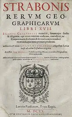
Title page of the 1620 edition of Isaac Casaubon's Geographica, whose 840 page numbers prefixed by "C" are now used as a standard text reference.
The Geographica (Ancient Greek: Γεωγραφικά, Geōgraphiká; Latin: Geographica or Strabonis Rerum Geographicarum Libri XVII, "Strabo's 17 Books on Geographical Topics") or Geography, is an encyclopedia of geographical knowledge, consisting of 17 'books', written in Greek in the late first century BC, or early first century AD, and attributed to Strabo, an educated citizen of the Roman Empire of Greek descent. There is a fragmentary palimpsest dating to the fifth century. The earliest manuscripts of books 1–9 date to the tenth century, with a thirteenth-century manuscript containing the entire text.[1]
Title of the work
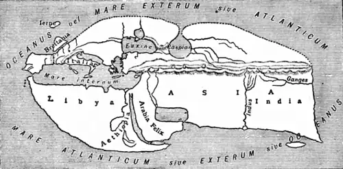
Map of the world according to Strabo
Strabo refers to his Geography within it by several names:[2]
Apart from the "outline", two words recur, "earth" and "country." Something of a theorist, Strabo explains what he means by Geography and Chorography:[7]
It is the sea more than anything else that defines the contours of the land (geōgraphei) and gives it its shape, by forming gulfs, deep seas, straits and likewise isthmuses, peninsulas, and promontories; but both the rivers and the mountains assist the seas herein. It is through such natural features that we gain a clear conception of continents, nations, favourable positions of cities and all the other diversified details with which our geographical map (chorographikos pinax) is filled.
From this description it is clear that by geography Strabo means ancient physical geography and by chorography, political geography. The two are combined in this work, which makes a "circuit of the earth" detailing the physical and political features. Strabo often uses the adjective geōgraphika with reference to the works of others and to geography in general, but not of his own work. In the Middle Ages it became the standard name used of his work.
The date of Geographica is a large topic, perhaps because Strabo worked on it along with his History for most of his adult life. He traveled extensively, undoubtedly gathering notes, and made extended visits to Rome and Alexandria, where he is sure to have spent time in the famous library taking notes from his sources.
Strabo did not date his work and determining this has been a matter of scholarly study since the Renaissance. The earliest attempts were in the 16th and 17th centuries (such as the 1549 Basel edition and the 1571 Heidelberg edition) however the first serious attempt was by Johannes Fabricus in 1717.[8]
Strabo visited Rome in 44 BC at age 19 or 20 apparently for purposes of education. He studied under various persons, including Tyrannion, a captive educated Greek and private tutor, who instructed Cicero's two sons. Cicero says:[9]
The geographical work I had planned is a big undertaking...if I take Tyrannion's views too...
If one presumes that Strabo acquired the motivation for writing geography during his education, the latter must have been complete by the time of his next visit to Rome in 35 BC at 29 years old. He may have been gathering notes but the earliest indication that he must have been preparing them is his extended visit to Alexandria 25–20 BC. In 20 he was 44 years old. His "numerous excerpts" from "the works of his predecessors" are most likely to have been noted at the library there.[10] Whether these hypothetical notes first found their way into his history and then into his geography or were simply ported along as notes remains unknown.
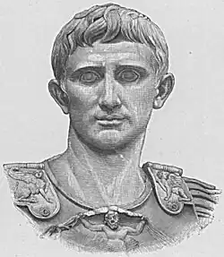
20th century drawing of Augustus
Most of the events of the life of Augustus mentioned by Strabo occurred 31–7 BC with a gap 6 BC – 14 AD, which can be interpreted as an interval after first publication in 7 BC.[11] Then in 19 AD a specific reference dates a passage: he said that the Carni and Norici had been at peace since they were "stopped ... from their riotous incursions ...."[12] by Drusus 33 years ago, which was 15 BC, dating the passage to the summer 19 AD.[13][8] The latest event mentioned is the death of Juba at no later than 23 AD, when Strabo was in his 80s. These events can be interpreted as a second edition unless he saved all his notes and wrote the book entirely after the age of 80. Dueck concludes that the Geography was written between AD 18–24.[8]
Composition
Strabo is his own best expounder of his principles of composition:[14]
In short, this book of mine should be ... useful alike to the statesman and to the public at large – as was my work on History. ... And so, after I had written my Historical Sketches ... I determined to write the present treatise also; for this work is based on the same plan, and is addressed to the same class of readers, and particularly to men of exalted stations in life. ... in this work also I must leave untouched what is petty and inconspicuous, and devote my attention to what is noble and great, and to what contains the practically useful, or memorable, or entertaining. ... For it, too, is a colossal work, in that it deals with the facts about large things only, and wholes ....
Content
An outline of the encyclopedia follows, with links to the appropriate Wikipedia article.
Book I – definition and history of geography
Pages C1 through C67, Loeb Volume I pages 3–249.
Chapter 1 – description of geography and this encyclopedia
The Mediterranean, the land of the Cimmerians, the Ister.
11
Anaximander and Hecataeus.
12
Hipparchus and the climata.
13
The antipodes.
14–19
The ecumene. Geography requires encyclopedic knowledge of celestial, terrestrial and maritime features as well as natural history and mathematics and is of strategic interest.
20
Earth is a sphere with surface curved by the law of gravity, that bodies move to the center.
21
Knowledge of geometry is required to understand geography.
22–23
The purpose and plan of the encyclopedia.
Chapter 2 – contributors to geography
Book
Section
Description
I.2
1
Contributions of the Romans and Parthians to geography
Recommends Alexander the Great's division of people into good or bad rather than the traditional Greek barbarians and Greeks.
Book II – mathematics of geography
Pages C67 through C136, Loeb Volume I pages 252–521.
Chapter 1 – distances between parallels and meridians
Book
Section
Description
II.1
1–3
Relates Eratosthenes' description of the Tropic of Cancer, which was based on Patrocles.
4–5
Critiques Hipparchus' criticism of Patrocles, which was based on Deimachus and Megasthenes. Points out that Eratosthenes used the Library of Alexandria.
Calculations of distances between parallels and meridians passing through various places in the habitable world, according to various geographers: Hipparchus, Eratosthenes, Pytheas, Deimachus.
Chapter 2 – the five zones
Book
Section
Description
II.2
1
Introduces the work Oceans by Poseidonius.
2–3
Critiques Poseidonius, who criticises Parmenides and Aristotle on the widths and locations of the five zones.
Chapter 3 – distribution of plants, animals, civilizations
Book
Section
Description
II.3
1–3
Critiques the six zones of Polybius.
4
Describes African voyages: the circumnavigation by an expedition sent by Necho II, another by Magus; to India by Eudoxus of Cyzicus.
5
Adventures and misadventures of Eudoxus. Attacks the credibility of Pytheas, Euhemerus, Antiphanes.
6
Poseidonius' theory of Atlantis; attributes migration of Cimbri to inundation.
7
Attributes the distribution of plants, animals and civilizations to chance (suntuchia) rather than to zones (which was Poseidonius' theory).
8
Example of random racial distribution: Ethiopians were in both Asia (India) and Libya (Africa). Strabo says his school avoids such causal connections.
Chapter 4 – criticisms of Polybius' and Eratosthenes' maps
Book
Section
Description
II.4
1–2
Polybius' critique of Pytheas.
3
Strabo's criticisms of Polybius' European distances.
4
Strabo's criticisms of Polybius' critique of the distances of Eratosthenes.
5–6
Strabo's corrections to various geographers' descriptions of the locations of the Tanaïs, the Tyras, the Borysthenes and the Hypanis.
7
Strabo criticises Polybius' length of the inhabited world.
8
Strabo criticises Polybius' and Eratosthenes' physical divisions of Europe.
Chapter 5 – Strabo's view of the ecumene
Book
Section
Description
II.5
1
Representation of a spherical surface as a plane requires the geographer to be a mathematician.
The inhabited world is an island shaped like a truncated cone, in a spherical quadrilateral formed between the equator, the arctic circle and a great circle passing through the poles. The island is 70,000 stadia long by 30,000 stadia wide.
7
Hipparchus says the equator is 252,000 stadia long; the great circle distance from equator to pole is 63,000 stadia.
8
Strabo does not believe Pytheas that Thule is farthest north at the Arctic Circle. He thinks no one is north of Ierne. He believes the Romans scorned to invade Britain as being worthless.
9
The length and width of the inhabited world are 70,000 and 30,000 stadia respectively.
10
Strabo recommends representing the Earth on a globe of no less than 10 feet in diameter or on a plane map of at least 7 feet.
11–12
Strabo says he personally travelled from Armenia to Tyrrhenia and from the Euxine Sea to the frontiers of Ethiopia. He and all other geographers receive information mostly by hearsay. He went up the Nile river with his friend Aelius Gallus, prefect of Egypt, to the edge of Ethiopia and Syene.
13–16
The known limits of the Earth are Meroe in the Nile river, Ierne, the Sacred Promontory beyond the Pillars of Hercules and east of Bactriana.
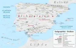
Representation on a modern map of Iberia according to Strabo.
Chapter 1 – Vicinity of the Sacred Cape
Book
Section
Description
III.1
1–3
Ibēria is poor, inhospitable and mountainous, 6000 stadia N–S, 5000 E–W. The Purēnē oros is aligned N–S and separates Ibēria from Keltikē.[15]
4
The Sacred Cape is the westernmost point of the inhabited world.[16] The country next to it is called Cuneus, "wedge", in the Latin language from its shape. It is occupied by the Ibēres across the straits from the Maurousioi.
5
Strabo repeats Poseidonius' assertion that the setting sun is larger at the coast because of a lens effect through the water vapor. He says Artemidorus is wrong in claiming a size of 100 times larger and that he could not have seen it because the cape was taboo at night.
6
South West Iberia is delimited by the Tagus river (to the north of the Sacred Cape) and the Anas river to the east. The region is populated by the Keltikoi and some Lusitanai resettled there from beyond the Tagus by the Romans. Inland are the Karpētanoi (Madrid region), the Ōrētanoi (La Mancha and eastern Sierra Morena, and the Ouettōnoi (Salamanca region). The fertile southeast, Baetica (Andalusia region), east of the Baetis river after which it is named, is occupied by the Tourdētanoi or Tourdouloi, who have writing and a literature. Other Iberians have alphabets, but not the same, as they do not all use the same languages (glōttai).
Chapter 2 – Bætica
Book
Section
Description
III.2
1–2
Bætica is the region around the Bætis river, main cities are Corduba and Gadira.
3–5
Bætis river is navigable and boats go from the sea to Corduba.
6
Bætica soil is fertile, it exports a lot of wheat, wine, and oil.
7
Bætica littoral is full of fish, especially fat tuna, which eat a lot of acorns like some "sea pigs".
8
Bætica subsoil is full of gold, silver, cooper, and iron.
9–10
How gold and silver are extracted from the soil of Baetica and other regions of Hispania.
11–13
What Homer says about Bætica.
14–15
Bætica was a Phœnician colony, now it's romanised.
'Celtica beyond the Alps' (Gaul), its inhabitants and boundaries
2
The agriculture and landscapes of Gaul
3
The cities and towns of Narbonitis
4
The cult of Ephesian Artemis in Massalia (Marseille)
5
The government and society of Massalia, its interactions with Rome, and the founding of Aquae Sextiae (Aix)
6
The coastline around Massalia, including the Galactic Gulf; the site and trade of Narbo (Narbonne)
7
The mysterious rocks of the Stony Plain, and the causes given by other writers
8
Siltation and oyster-fishing in the mouth of the Rhodanus (Rhône)
9
The remaining settlements of the coastline, including Forum Iulium (Fréjus), Nicaea (Nice) and Antipolis (Antibes)
10
The Stoechades Islands (Îles d’Hyères) and other coastal islands
11
The towns and rivers of the Cévennes and the Rhône basin as far as Lemenna (lac Léman), including Avenio (Avignon), Arausio (Orange) and Vienna (Vienne)
12
The right bank of the Rhône, including Nemausos (Nîmes)
13
Historical migration from Gaul to Cappadocia
14
Tolossa (Toulouse) and river trade in Gaul
Chapter 2 – Aquitania
Book
Section
Description
IV
1
The geography of Aquitania, between the Pyrenees and the Liger (Loire) via the Garumna (Garonne)
2
The inhabitants of Aquitania
3
The history of Vercingetorix and the Arverni, including the settlements of Cenabum (Orléans), Gergovia (Gergovie) and Alesia (Alise-Sainte-Reine)
The shape of Italy, its geography, and the rivers and cities of the north; the River Padus (Po), Mediolanum (Milan), Comum (Como), Patavium (Padua), and Ravenna
2
The places of northwestern Italy, including the River Tiber, the quarry at Carrara, Pisa, and the islands of Elba, Corsica and Sardinia; also ethnographies of Italian peoples, including the Tyrrhenians (Etruscans), the Caeretanians, and the mysterious Pelasgians.
3
4
5
6
7
8
9
10
11
12
Chapter 2 – Tuscany and Umbria
Book
Section
Description
V
1
2
3
4
5
6
7
8
9
10
Chapter 3 – The Sabine Hills and Latium
Book
Section
Description
V
1
2
3
4
5
6
7
8
9
10
11
12
13
Chapter 4 – Picenum and Campania
Book
Section
Description
V
1
2
3
4
5
6
7
8
9
10
11
12
13
Book VI – south Italy, Sicily
Chapter 1 – Southern Italy
Book
Section
Description
VI
1
2
3
4
5
6
7
8
9
10
11
12
13
14
15
Chapter 2 – Sicily
Book
Section
Description
VI
1
2
3
4
5
6
7
8
9
10
11
Chapter 3 – Greece
Book
Section
Description
VI
1
2
3
4
5
6
7
8
9
10
11
Chapter 4 – Italy summary
Book
Section
Description
VI
1
2
Book VII – north, east and central Europe
Chapter 1 – Germania
Book
Section
Description
VII
1
Overview of the lands to be covered in the rest of the text.
The Nile in Ethiopia. The organization of Egypt, nomes, classes, comments on the Labyrinth.
4
The Nile in the Nile Delta
5
Source of the Nile. Greek writers about the Nile. Definition of the name Aegypt.
6
Harbours of Alexandria, Pharos Island. Julius Caesar. Founding of the city by Alexander the Great.
7
Importance of Alexandria. Lake Mareotis
8
Details about Alexandria. Ptolemy I Soter steals Alexanders body. Perdiccas is slain. Roxana departes for Macedonia.
9
Lighthouse of Alexandria. Other temples and buildings, Lochias (promontory), Royal palace, Antirrhodos (island), Theatre, Poseidium, Emporium, Timonium, Caesarium, Heptastadium.
10
More details about Alexandria. More buildings and structures. The Sarapium. Emperor Augustus defeats Mark Antony.
11
The Ptolemaic dynasty
12–13
Egypt as a Roman province. Roman Legions. Polybius' visit to Alexandria.
14
Coastal cities from Cyrenaica to Alexandria. About wine.
15
Papyrus, Cyperus and Cyperus papyrus in the Deltaic marshes and lakes.
16–17
Road to Canopus. Temple of Sarapis.
18
Nile mounts in the Delta, Canopic (Canopus), Bolbitine (Rosetta), Sebennytic (Buto), Phantnitic (Damietta), Mendesian (Mendes), Tanitic (Tanis) and Pelusiac (Pelusium).
19
(sect. 19–21: Interior of the mouth of the river Nile; expulsion of foreigners; difficulty in entering Egypt.) cities Xoïs, Hermupolis, ... Mendes, ...
20
Athribis ... Tanis
21
Pelusium ... Heroönpolis
22
Lake Mareia, ...
23
... Naucratis, Saïs
24
discord among the Egyptians over the schoenus (i.e. a unit of distance)
25
city of Arsinoê; canal through the Bitter Lakes to the Gulf of Suez
26
Heroönpolis ... Phacussa
27–39
...
40
Cynonpolis ('City of Dogs'), ... ; overview of different animals worshipped by separate Egyptian groups or by all Egyptians in common
41
Hermopolitic garrison, Thebaïc garrison, ...
42
... Abydus
43
the oracle at Ammon visited by Alexander the Great
44
temple of Osiris in Abydus; city of Tentyra
45
cities Berenicê (at the Red Sea), Myus Hormus, Coptus ... ; mines of smaragdus
46
Thebes
47
city Hermonthis; a City of Crocodiles; a City of Aphroditê; Latopolis; a City of Hawks; Apollonospolis
48
Syenê; Elephantinê; nilometer
49
the First Cataract, above Elephantinê; settlement Philae, holding an Aethiopian bird in honour
50–54
...
Chapter 2
Book
Section
Description
17
1–3
Ethiopia
4—5
...
Chapter 3
Book
Section
Description
17
1–25
...
Publication History
Manuscripts
Some thirty manuscripts of Geographica or parts of it have survived, almost all of them medieval recensions, though there is 5th century palimpsest (in 3 parts) and fragmentary papyri of the 2nd - 3rd centuries. Attempts at critical editions during the 1840s-50s Kramer, Meineke, Müller and Dübner did not benefit from these discoveries which only occurred after their publications.[17]
The critical text of Strabo is primarily based on 5 prototype manuscripts:[18]
Rare 5th century bi-rescriptus (twice rewritten) palimpsest, now split into 3 manuscripts. Written in 3 columns of Greek ogival majuscule.[22] Originally of 44 square leaves, similar to the Codex Sinaiticus and Codex Vaticanus. Possibly written in Caesarea and held in the Law school of Berytus. Erased and rewritten with the Nomocanon in the 8th century and finally again with Pentateuch and Gregory of Nazianzus’ Orations in Southern Italy the 10th century.[23]
Today there are about thirty manuscripts in existence, with a fragmentary palimpsest of the fifth century the earliest (Vaticanus gr. 2306 + 2061 A).[23] Two manuscripts in Paris provide the best extant text: Parisinus gr. 1397 of the tenth century for Books 1-9, and Parisinus gr. 1393 of the thirteenth century for the entire text. The end of Book 7 had been lost sometime in the latter Byzantine period.
A Latin translation commissioned by Pope Nicholas V appeared in 1469: this was the edition probably used by Columbus and other early Renaissance explorers. The first printed Greek edition was the Aldine of 1516,[34] and the first text with commentary was produced by Isaac Casaubon in Geneva in 1587. The Teubner edition appeared in 1852-3 under the editorship of August Meineke.[35]
The first semi-critical Greek text was established by Kramer, Meineke, Müller and Dübner during the 1840s-50s, notably before the discovery and study of the 5th century palimpsets by Cardinal Angelo Mai, Giuseppe Cozza Luzi and Pierre Batiffol in 1844, 1875 and 1888.[17] The first fully critical edition was only completed in 2011 Stefan Radt.[36]
Strabo (1917–1932). The Loeb Classical Library: The Geography of Strabo: in Eight Volumes (in Ancient Greek and English). Translated by Jones, Horace Leonard. Cambridge, Massachusetts/London: Harvard University Press/William Heinemann. Contains Books 1–17, Greek on the left page, English on the right. Sterrett translated Books I and II and wrote the introduction before dying in 1915. Jones changed Sterrett's style from free to more literal and finished the translation. The Introduction contains a major bibliography on all aspects of Strabo and a definitive presentation of the manuscripts and editions up until 1917. Greek text based on Meineke (1852–53).
Roller, Duane W. (2014). The Geography of Strabo: An English Translation, with Introduction and Notes. Cambridge University Press. ISBN 978-1-139-95249-1.
Pothecary, Sarah (2024). Strabo's Geography: A Translation for the Modern World. Princeton University Press. ISBN 978-0-691-24313-9.
^Strabo, and Duane W Roller. The Geography of Strabo. New York, Cambridge University Press, 2014, pp. 51
^Dueck, Daniela (2000). Strabo of Amasia: A Greek Man of Letters in Augustan Rome. London, New York: Routledge: Taylor & Francis Group. p. 145. ISBN 0-415-21672-9.
Greek Wikisource has original text related to this article: Γεωγραφικά
Strabo (1924). H.L. Jones (ed.). "Strabo: The Geography". LacusCurtius. Translated by Jones. Retrieved 2007-11-03.
Strabo (1924). H.L. Jones (ed.). "Strabo, Geography". The Perseus Digital Library. Tufts University. Retrieved 2007-11-03. Books 6–14.
Strabo (1903-06-19). H.C. Hamilton; W. Falconer (eds.). "Strabo, Geography". The Perseus Digital Library. Tufts University. Retrieved 2007-11-03.
Strabo (1852–1853). A. Meineke (ed.). "Strabo, Geography". The Perseus Digital Library (in Greek). Tufts University. Retrieved 2007-11-03. Books 6–14.
Strabo (1917–1932). The Loeb Classical Library: The Geography of Strabo: in Eight Volumes (in Ancient Greek and English). Translated by Jones, Horace Leonard. Cambridge, Massachusetts/London: Harvard University Press/William Heinemann. Complete series at the Internet Archive.
 Greek Wikisource has original text related to this article: Γεωγραφικά