Malir District
Malir District
ضلع ملیر | |
|---|---|
District of Sindh | |
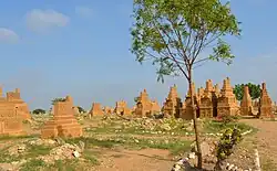 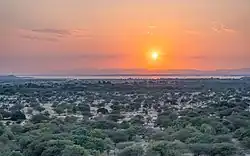 Top: Chaukhandi tombs Bottom: Kirthar National Park | |
 Seal | |
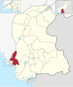 Map of Malir District | |
| Country | |
| Province | |
| Division | Karachi |
| Headquarters | DC Malir |
| Preceded | District Karachi East (1972-1996) |
| Established | 1996 |
| Abolished | 2001 |
| Restored | 11 July 2011 |
| Administration | DMC Malir[1] |
| Administrative Subdivisions/Tehsils | 06 |
| Government | |
| • Type | District Administration |
| • Body | Government of Karachi |
| • Deputy Commissioner | Capt (Rtd) Muhammad Saeed Laghari, PAS |
| • National Assembly Seats (2024) | Total 3
NA-230 Karachi Malir-II NA-231 Karachi Malir-III |
| • Provincial Assembly Seats (2024) | Total 6
PS-85 Karachi Malir-II PS-86 Karachi Malir-III PS-87 Karachi Malir-IV PS-88 Karachi Malir-V PS-89 Karachi Malir-VI |
| Area | |
• District of Sindh | 2,160 km2 (830 sq mi) |
| Elevation | 11 m (36 ft) |
| Population (2023)[3] | |
• District of Sindh | 2,419,736 |
| • Density | 1,100/km2 (2,900/sq mi) |
| • Urban | 1,155,058 |
| • Rural | 1,264,678 |
| Demonym | Karachiite |
| Literacy | |
| • Literacy rate |
|
| Time zone | UTC+05:00 (PKT) |
| • Summer (DST) | DST is not observed |
| ZIP Code | 75050 |
| NWD (area) code | 021 |
| ISO 3166 code | PK-SD |
| CNIC Code of Malir District | 42501-XXXXXXX-X |
| Website | dcmalir |
Malir District (Urdu: ضلع ملير) is an administrative district of Karachi Division in Sindh, Pakistan created in 1996 by bifurcation of District Karachi East. According to the 2023 Pakistani census, District Malir had a population of 2,419,736 (2.4 million).
History
Malir is a Sindhi word which means "greenery".[5] Before the independence of Pakistan, there were small villages of Sindhi and Kalmati Baloch in Gadap Town and Malir Town of modern Karachi. Now both towns have developed as the suburbs of the city because of the urban sprawl.[6]
Countryside
Malir has been regarded in history as the countryside of Karachi City due to its open atmosphere and lush green farms, but now these are no more.[7]
Agriculture land
Malir was once famous for its fruit and vegetable farms; but, now due to severe scarcity of groundwater, these farmlands are being converted into residential areas, thus increasing urbanization and environmental degradation. The Society for Conservation and Protection of Environment (SCOPE) has been concerned about drought and desertification in Malir district and has launched a campaign against illegal sand and gravel mining in the dry river beds of the Malir and its tributaries. Sand and gravel mining cause lowering of ground water, as rainwater cannot percolate in the aquifer. SCOPE is developing rainwater reservoirs in drought affected rural areas.[8]
Politics
The Pakistan People's Party (PPP) has historically dominated elections in Malir District, winning all National Assembly and Provincial Assembly seats in recent elections.[9][10]
PPP’s popularity in Malir attributed to demographics and its historical development projects. The district has a large Sindhi- and Balochi-speaking population in rural and semi-urban areas, who traditionally support PPP.[11]
In the 1970s, under the leadership of Prime Minister Zulfiqar Ali Bhutto, several landmark industrial projects were initiated in the Bin Qasim subdivision of Malir District:
- Port Qasim – The foundation stone was laid in 1973 by Bhutto to create Pakistan’s second deep-water port.[12]
- Pakistan Steel Mills – Conceived and built during Bhutto’s tenure, located near Port Qasim, it became Pakistan’s first integrated steel plant and one of the largest industrial complexes in the country.[13]
- Pakistan Machine Tool Factory (PMTF) – Established in 1968 in Karachi and expanded under Bhutto, it provided a machinery base for Pakistan’s industrialization and is situated near the Bin Qasim industrial area.[14]
These industrial projects brought employment and infrastructure to Malir, reinforcing PPP’s political base and long-term popularity in the district.
Administrative status
Malir District was established in 1996.
Malir District was abolished in 2000 and divided into three towns namely:
- Gadap Town,
- Malir Town
- and Bin Qasim Town.
On 11 July 2011, Sindh Government restored again Malir District.[15]
In 2022, a/c to Local Election Act -2022 (amended), Malir District was divided into three "Town Municipal Corporation"[16] namely:
- Gadap Town
- Malir Town
- Ibrahim Hyderi Town
Headed by the TMC Chairman.
Town Municipal Corporations (TMC's) and Union Councils (UC's)
Following is the list of towns in Malir District.[17]
| Union Council |
|---|
| U.C. 1 Gadap |
| U.C. 2 Gaghar |
| U.C. 3 Pipri |
| U.C. 4 Gulshan-e-Hadeed |
| U.C. 5 Steel Town |
| U.C. 6 Saleh Muhammad Goth |
| U.C. 7 Murad Memon Goth |
| U.C. 8 Darsano Chana |
| U.C. 9 Shah Mureed |
| Union Council |
|---|
| U.C. 1 Gharibabad |
| U.C. 2 Dawood Goth |
| U.C. 3 Jafar-e-Tayyar |
| U.C. 4 Khuldabad |
| U.C. 5 Qaidabad |
| U.C. 6 Dawood Chowrangi |
| U.C. 7 Future Colony |
| U.C. 8 Sharafi Goth |
| U.C. 9 Bakhtawar Goth |
| U.C. 10 Bhittaiabad |
| Union Council |
|---|
| U.C. 1 Chaukhandi |
| U.C. 2 Shah Latif Town |
| U.C. 3 Cattle Colony |
| U.C. 4 Majeed Colony |
| U.C. 5 Muzzaffarabad |
| U.C. 6 Muslimabad |
| U.C. 7 Sher Pao colony |
| U.C. 8 Ibrahim Hyderi |
| U.C. 9 Chashma |
| U.C. 10 Rehri Goth |
| U.C. 11 Ali Akber Shah |
Administrative Sub-divisions (Tehsils)
Malir district is divided into Six subdivisions (tehsils).
| Subdivision (Tehsil)[4] | Area (km2) |
Population (2023) |
Density (ppl/km2) |
|---|---|---|---|
| Airport Subdivision | 41 | 254,370 | 6,204.15 |
| Bin Qasim Subdivision | 447 | 322,915 | 722.40 |
| Gadap Subdivision | 1,104 | 100,351 | 90.90 |
| Ibrahim Hyderi Subdivision | 250 | 200,000 | 800 |
| Murad Memon Subdivision | 195 | 376,987 | 1,933.27 |
| Shah Mureed Subdivision | 276 | 35,987 | 130.39 |
| 2,160 | 2,432,248 | 1,126.04 |
Demographics
| Year | Pop. | ±% p.a. |
|---|---|---|
| 1961 | ... | — |
| 1972 | ... | — |
| 1981 | ... | — |
| 1998 | 914,765 | — |
| 2017 | 1,924,346 | +3.99% |
| 2023 | 2,432,248 | +3.98% |
| Sources:[21] | ||
As of the 2023 census, Malir district has 421,426 households and a population of 2,432,248.[22] The district has a sex ratio of 112.70 males to 100 females and a literacy rate of 63.14%: 67.74% for males and 57.84% for females.[3][23] 624,172 (25.8% of the surveyed population) are under 10 years of age.[24] 1,166,340 (47.95%) live in urban areas.[3]
The majority religion is Islam, with 96.45% of the population. Christianity is practiced by 1.82% and Hinduism (including Scheduled Castes) is practiced by 1.66% of the population.[25]
Languages
- Sindhi (35.0%)
- Pashto (17.7%)
- Urdu (15.8%)
- Punjabi (9.94%)
- Balochi (7.88%)
- Hindko (5.69%)
- Saraiki (3.22%)
- Others (4.79%)
At the time of the 2023 census, 34.98% of the population spoke Sindhi, 17.71% Pashto, 15.79% Urdu, 9.94% Punjabi, 7.88% Balochi, 5.69% Hindko and 3.22% Saraiki as their first language.[26]
See also
- Divisions of Pakistan
- Divisions of Balochistan
- Divisions of Khyber Pakhtunkhwa
- Divisions of Punjab
- Divisions of Sindh
- Divisions of Azad Kashmir
- Divisions of Gilgit-Baltistan
- Tehsils of Pakistan
- Tehsils of Punjab, Pakistan
- Tehsils of Khyber Pakhtunkhwa, Pakistan
- Tehsils of Balochistan, Pakistan
- Tehsils of Sindh, Pakistan
- Tehsils of Azad Kashmir
- Tehsils of Gilgit-Baltistan
- Districts of Pakistan
- Districts of Khyber Pakhtunkhwa, Pakistan
- Districts of Punjab, Pakistan
- Districts of Balochistan, Pakistan
- Districts of Sindh, Pakistan
- Districts of Azad Kashmir
- Districts of Gilgit-Baltistan
- Malir Development Authority
- Malir (disambiguation)
- Malir Expressway Project
- Malir River
- Malir Cantonment
- Malir Cantonment railway station
References
- ^ "Contact Us". dcmalir.sindh.gov.pk. Retrieved 31 December 2023.
- ^ "Core Team". dcmalir.sindh.gov.pk. Retrieved 31 December 2023.
- ^ a b c "7th Population and Housing Census - Detailed Results: Table 1" (PDF). Pakistan Bureau of Statistics.
- ^ a b "AREA, POPULATION BY SEX, SEX RATIO, POPULATION DENSITY, URBAN POPULATION, HOUSEHOLD SIZE AND ANNUAL GROWTH RATE, CENSUS-2023, SINDH" (PDF). pbs.gov.pk. Retrieved 5 September 2025.
- ^ Angaria, Waqas Alam (14 February 2025). "Ecology vs. development in Karachi: Interview with photographer Salman Baloch". Mongabay Environmental News. Retrieved 28 February 2025.
- ^ "From Zardaris to Makranis: How the Baloch came to Sindh". The Express Tribune. 27 March 2014. Retrieved 18 October 2020.
- ^ "Save the Green Belt of Malir". The Nation. 18 August 2019. Retrieved 18 October 2020.
- ^ "SCOPE - Society for Conservation and Protection of Environment". www.scope.org.pk. Retrieved 7 March 2022.
- ^ "Fresh delimitations confirm PPP dominance in Malir". Dawn. 16 December 2023. Retrieved 6 September 2025.
- ^ "Sequence of Karachi's constituencies changed after fresh ECP delimitation". The Express Tribune. 27 September 2023. Retrieved 6 September 2025.
- ^ "The rural strength of PPP in Karachi". The News International. 9 July 2023. Retrieved 6 September 2025.
- ^ "Shaheed Zulfikar Ali Bhutto – Achievements in Infrastructure". Research Centre for Conservation of Bhutto Heritage. Retrieved 6 September 2025.
- ^ "A look back at history of Pakistan Steel Mills". The Express Tribune. 12 November 2013. Retrieved 6 September 2025.
- ^ "Pakistan Machine Tool Factory". Wikipedia. Retrieved 6 September 2025.
- ^ Five districts of Karachi restored, notification issued Geo TV News website, Published 11 July 2011, Retrieved 7 March 2022
- ^ "Karachi to have 26 towns, 233 union bodies under Sindh LG Act". Business Recorder (newspaper). 9 January 2022. Retrieved 22 January 2023.
- ^ Tahir Siddiqui (8 January 2022). "Division of Karachi into 26 towns, 233 UCs notified (by the government)". Dawn (newspaper). Retrieved 28 January 2022.
- ^ "Union Councils List".
- ^ "Union Councils List".
- ^ "Union Councils List".
- ^ "Population by administrative units 1951-1998" (PDF). Pakistan Bureau of Statistics.
- ^ "7th Population and Housing Census - Detailed Results: Table 20" (PDF). Pakistan Bureau of Statistics.
- ^ "7th Population and Housing Census - Detailed Results: Table 12" (PDF). Pakistan Bureau of Statistics.
- ^ "7th Population and Housing Census - Detailed Results: Table 5" (PDF). Pakistan Bureau of Statistics.
- ^ a b "7th Population and Housing Census - Detailed Results: Table 9" (PDF). Pakistan Bureau of Statistics.
- ^ a b "7th Population and Housing Census - Detailed Results: Table 11" (PDF). Pakistan Bureau of Statistics.
25°05′46″N 67°11′14″E / 25.0960°N 67.1871°E
Districts of Sindh | ||
|---|---|---|
Provincial capital: Karachi | ||
| Hyderabad | 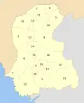 | |
| Karachi |
| |
| Larkana | ||
| Mirpur Khas | ||
| Shaheed Benazir Abad | ||
| Sukkur | ||