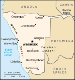
Map of Namibia showing the Caprivi Strip in the country's northeast.
A salient, panhandle, or bootheel is an elongated protrusion of a geopolitical entity, such as a subnational entity or a sovereign state.
While similar to a peninsula in shape, a salient is most often not surrounded by water on three sides. Instead, it has a land border on at least two sides and extends from the larger geographical body of the administrative unit.
In American English, the term panhandle is often used to describe a relatively long and narrow salient, such as the westernmost extensions of Florida and Oklahoma, or the northernmost portion of Idaho. Another term is bootheel, used for the Missouri Bootheel and New Mexico Bootheel areas.
Origin
The term salient is derived from military salients. The term "panhandle" derives from the analogous part of a cooking pan, and its use is generally confined to North America.
The salient shape can be the result of arbitrarily drawn international or subnational boundaries, which serve to separate culturally unified peoples.[1] These occurred, for instance, during European colonialisation when colonial powers competed for Africa and the Western Hemisphere, after which post-colonial borders became based on colonial divisions.[2] In many cases these salients correspond to routes of expansion or bases for such expansion, as in Namibia and Mozambique.[3] Other modern salients originally served to provide barriers against other colonial powers, as with Britain against Tsarist Russia in Central Asia.[1]
Salients may also arise when a national government shifts territory between subnational entities for internal political reasons, as with West Virginia's eastern panhandle during the Civil War.[4] This also occurred with peripheral Tibetan-inhabited regions in Maoist China, which were split between provinces and from the Tibet Autonomous Region.[5]
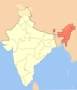
The location of administrative borders can also take into account other considerations such as economic ties,[6] strategic needs,[7] history or topography. Even in these situations, however, salients frequently fail to follow clear and logical criteria, as seen with the partition of India and the resultant northeastern salient. Upon partition numerous majority-Muslim areas remained within Hindu India, and some non-Muslim-majority areas within the exclave of East Pakistan.[8]
Country-level salients
Africa
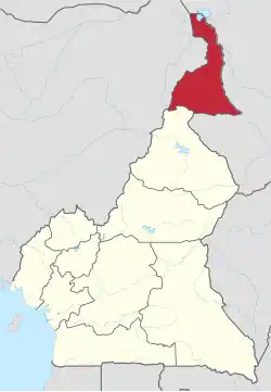
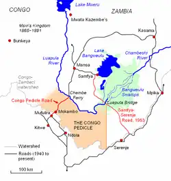
Far North Province of CameroonA map of the Congo Pedicle
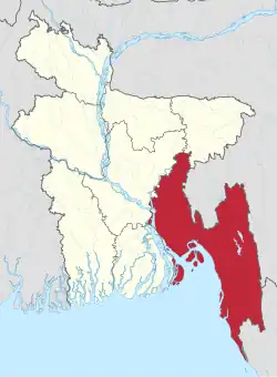
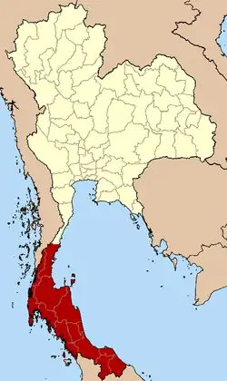
Chittagong Division, BangladeshMap of India showing the Seven Sister states in the northeast plus the smaller salient of Sikkim immediately to their west.The 14 provinces of Thailand forming the salient of Southern Thailand.
The following locations are salients in first-level administrative subdivisions of nations.
Africa
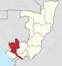
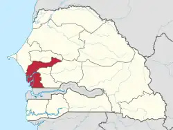
Location of Niari Department within the Republic of the Congo. The southeastern arm is the Kimongo District.Location of the Fatick Region within Senegal. Gossas Department is the northeastern arm.
Gokwe North and Gokwe South Districts, Midlands Province
Zimbabwe
South America
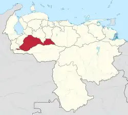
Guayas Province, Ecuador. Balzar and El Empalme Cantons form the northern arm of the province.Venezuela's Barinas State. Andrés Eloy Blanco is the small western extension of the state, Arismendi is the larger eastern extremity. Páez, in Apure, lies immediately to the south of western Barinas.
Salient
Country
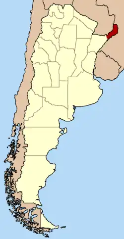
Southern Buenos Aires Province
Argentina
Luis Calvo, Chuquisaca Department
Bolivia
Sud Cinti, Chuquisaca Department
Whale Coast, Bahia
Brazil
Alto Parnaíba, Balsas, and Tasso Fragoso, southernmost Maranhão
Northern Mato Grosso
Ponta do Abunã in northwest Rondônia
Triângulo Mineiro, Minas Gerais
Arauco Province, Bío Bío Region
Chile
San Antonio Province, Valparaíso Region
Urabá region, Antioquia Department
Colombia
Unguía and Acandí in northernmost Chocó Department
Santander Department northern tip
Santa Rosa and Piamonte in southeastern Cauca Department
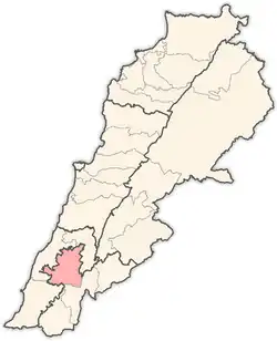
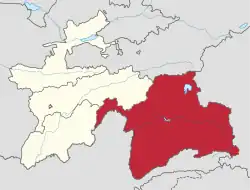
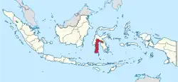
Location of Nabatieh District within Nabatieh Governorate, Lebanon.Map of Gorno-Badakhshan within Tajikistan, showing the panhandle of Darvoz District in the west.South Sulawesi in Indonesia, with a panhandle of East Luwu Regency in the east
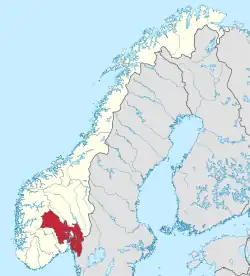
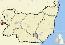
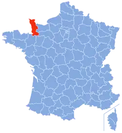
Location of Viken, Norway. The municipalities of Jevnaker and Lunner connect the former counties of Akershus and BuskerudLocation of Newmarket (shown as red dot) within Suffolk, EnglandLocation of Manche within Normandy, France
The area around Tring, Hertfordshire, which is itself bounded on one side by a salient of Buckinghamshire in the area around Pitstone, Ivinghoe and Dagnall
Ljig, Kolubara District
Serbia
Ljubovija, Mačva District
Bosnian-Podrinje Canton Goražde, Federation of Bosnia and Herzegovina
Bosnia and Herzegovina
Petrovo, Republika Srpska
Ravno, Herzegovina-Neretva Canton
Oceania
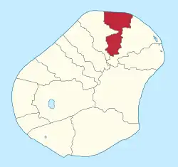
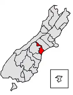
Location of Anetan District within NauruLocation of Timaru District within New Zealand's South Island. The Waitaki District is parallel with it, a little further south.
Salient
Country
Northeastern Nadroga-Navosa Province, Western Division
^This definition includes the following counties: Bay, Calhoun, Escambia, Franklin, Gadsden, Gulf, Holmes, Jackson, Jefferson, Leon, Liberty, Madison, Okaloosa, Santa Rosa, Taylor, Wakulla, Walton, and Washington.
^This definition includes the following counties: Allegany, Frederick, Garrett, and Washington
^Encompassing, in order of increasing distance from the main body of the oblast, Kusinsky District, Zlatoust Urban Okrug, Satkinsky District, Tryokhgorny Urban Okrug, Katav-Ivanovsky District, Ust-Katav Urban Okrug and Ashinsky District.
^Lowitt, Richard (2006). American Outback: The Oklahoma Panhandle in the Twentieth Century. Texas Tech University Press. pp. xvii, xviii. ISBN 9780896725584.
^Weigert, Hans W. (1957). Principles of Political Geography. New York City: Appleton-Century-Crofts. pp. 73–75.
^Hubbard, Bill (2008). "Chapter Five: The Evolution of the Territories and States". American Boundaries: The Nation, the States, the Rectangular Survey. University of Chicago Press. p. 167. ISBN 9780226355931.
^Sautman, Barry (2006). "Tibet and the (Mis)-Representation of Cultural Genocide". In Sautman, Barry (ed.). Cultural Genocide and Asian State Peripheries. New York City: Palgrave Macmillan. p. 207. ISBN 1403975744.
^Mellor, Roy E. H. (1989). National, State and Territory: A Political Geography. London: Routledge. p. 70. ISBN 9780415022873.
^Pounds, Norman John Greville (1972). Political geography (2nd ed.). New York City: McGraw-Hill (published 1963). p. 271. ISBN 9780070505667.
^Ali Tayyeb (1966). Pakistan; A Political Geography. London: Oxford University Press. p. 89.
_-_Bryansk_Oblast_(disputed_Crimea).svg.png)
.svg.png)