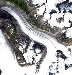
 Satellite image of the Pashleth Glacier
The Pashleth Glacier is a glacier south of the Machmell River and west of the Klinaklini Glacier in southwestern British Columbia, Canada.[1]
References
|
|---|
| Ranges | |
|---|
| Mountains | |
|---|
| Passes |
- Cayoosh
- Griswold
- McGillivray
- Pemberton
- Railroad
- Tyoax
- Wedge
|
|---|
| Glaciers | |
|---|
| Icefields | |
|---|
| Névés |
- Compton Névé
- Garibaldi Névé
|
|---|
| Communities |
- List of communities in British Columbia
|
|---|
| Parks |
- Clendinning
- Duffey Lake
- Garibaldi
- Mount Elphinstone
- Stein Valley Nlaka'pamux Heritage
- Spruce Lake (South Chilcotin)
- Upper Lillooet
- Golden Ears
- Tantalus
- Mehatl Creek
- Birkenhead Lake
- Joffre Lakes
- Ts'il?os
- Bishop River
- Princess Louisa Marine
- Callaghan
- Nairn Falls
- Brandywine Falls
- Alice Lake
- Blackcomb Glacier
- Tetrahedron
- Stawamus Chief
- Murrin
- Mount Seymour
- Cypress
- Say Nuth Khaw Yum (Indian Arm)
- Pinecone-Burke
- Shannon Falls
- Rolley Lake
- Sasquatch
- Big Creek
- Homathko Estuary
- Davis Lake
|
|---|
51°31′48″N 126°13′00″W / 51.53000°N 126.21667°W / 51.53000; -126.21667