The Alapaha River looking north from Naylor Landing The Alapaha River is a 202-mile-long (325 km)[ 1] river in southern Georgia and northern Florida in the United States . It is a tributary of the Suwannee River , which flows to the Gulf of Mexico .
History
The Hernando de Soto expedition narrative records mention a "Yupaha" village they encountered after they left Apalachee, "the sound of which is suggestive of the Alapaha, a tributary of the Suwanee."[ 2] [ 3] Indian Tribes of North America places the Indian village of Alapaha near where the Alapaha River met the Suwanee, and also noted that an Indian village of "Arapaja" was 70 leagues from St. Augustine, Florida , probably on the Alapaha River.[ 4] [ 5]
In the 1840s a German travel writer, Friedrich Gerstäcker wrote a dime novel called Alapaha, or the Renegades of the Border , giving the name to a noble Cherokee "squaw." A translation of this novel was published in the 1870s as #67 in a series of American narratives published by Beadle.[ 6]
During the American Civil War , the swamps along the Alapaha River in Berrien, Irwin, and Echols counties became a refuge for a number of gangs of Confederate deserters.[ 7]
Course
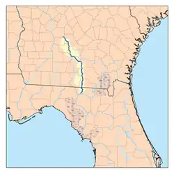
The Alapaha River rises in southeastern Dooly County, Georgia , and flows generally southeastwardly through or along the boundaries of Crisp , Wilcox , Turner , Ben Hill , Irwin , Tift , Berrien , Atkinson , Lanier , Lowndes and Echols Counties in Georgia, and Hamilton County in Florida, where it flows into the Suwannee River 10 miles (16 km) southwest of Jasper . Along its course it passes the Georgia towns of Pitts, Rebecca , Alapaha , Willacoochee , Lakeland , and Statenville .
Near Willacoochee, Georgia, the Alapaha collects the Willacoochee River. In Florida, it collects the Alapahoochee River and the short Little Alapaha River , which rises in Echols County, Georgia, and flows southwestward.
Intermittent river
The Dead River Sink Image of the entire surface water flow of the Alapaha River near Jennings, Florida going into a sinkhole leading to the Floridan aquifer groundwater . The Alapaha River is an intermittent river for part of its course. During periods of low volume, the river disappears underground and becomes a subterranean river . At approximately 2.3 miles (3.7 km) downstream from Jennings, Florida the Dead River enters the Alapaha River. It is a usually dry river bed with a number of sinkholes, including the Dead River Sink. During periods of low water flow, the Alapaha River downstream from the confluence of the Dead River and the Alapaha River flows upstream into the Dead River.
A few more miles downstream is a second sinkhole variously known as the Alapaha River Sink, Suck Hole, or the Devil's Den on the western bank of the river. At the latter point during the periods of low water flow, the Alapaha River disappears underground leaving a dry bank for much of the remainder of its course. The Alapaha River later reappears at the Alapaha River Rise, which is about a half mile upstream from the confluence of the Alapaha River and the Suwannee River (30°26′46″N 83°05′51″W / 30.446044°N 83.097483°W / 30.446044; -83.097483
Variant names
The United States Board of Geographic Names settled on the "Alapaha River" as the stream's name in 1891. According to the Geographic Names Information System , it has also been known as:
Alabaha River
Alapa Haw River
Alapa Hawchu River
Alla-pa-ha River
Allallehaw River
Allapacoochee River
Allapaha River
Allapauhau River
Allaphaw River
Allappaha River
Allopohaw River
Alloppehaw River
Alopaha River
Elapaha River
Lappahaw River
Lop Haw River
Lopaha River
Lopahatchy River
Loppahaw River
Low Haw River
Popaha River
Crossings
Crossing
Carries
Image
Location
ID number
Coordinates
Georgia
Griffin Road
32°01′27″N 83°36′37″W / 32.0243°N 83.6103°W / 32.0243; -83.6103
Buzzard Bridge
Willford Crossing Road
32°01′27″N 83°36′37″W / 32.0243°N 83.6103°W / 32.0243; -83.6103
County Line Road
32°01′11″N 83°36′37″W / 32.0198°N 83.6103°W / 32.0198; -83.6103
Seville Road
32°00′32″N 83°36′06″W / 32.0089°N 83.6016°W / 32.0089; -83.6016
Seville Road
32°00′32″N 83°36′06″W / 32.0089°N 83.6016°W / 32.0089; -83.6016
Seville-Pleasantview Road
31°59′50″N 83°35′27″W / 31.9973°N 83.5908°W / 31.9973; -83.5908
Old Cordele Road
31°59′07″N 83°34′40″W / 31.9853°N 83.5778°W / 31.9853; -83.5778
Flowers Road
31°58′39″N 83°34′34″W / 31.9775°N 83.5761°W / 31.9775; -83.5761
Watson Road
31°58′01″N 83°34′38″W / 31.9670°N 83.5771°W / 31.9670; -83.5771
Dowley Road
31°56′52″N 83°33′37″W / 31.9478°N 83.5604°W / 31.9478; -83.5604
Rail bridge
CSX Transportation
31°56′52″N 83°33′37″W / 31.9478°N 83.5604°W / 31.9478; -83.5604
US 280
Pitts, Georgia to Seville, Georgia
31°55′52″N 83°33′10″W / 31.9312°N 83.5527°W / 31.9312; -83.5527
Highway later replaced by
31°55′52″N 83°33′10″W / 31.9312°N 83.5527°W / 31.9312; -83.5527
31°55′49″N 83°33′07″W / 31.9303°N 83.5519°W / 31.9303; -83.5519
Hawkinsville and Florida Southern Railway (Abandoned 1920s)
31°55′24″N 83°32′43″W / 31.9234°N 83.5453°W / 31.9234; -83.5453
31°51′31″N 83°28′47″W / 31.8587°N 83.4797°W / 31.8587; -83.4797
Jay Calhoun Road
31°51′31″N 83°28′47″W / 31.8587°N 83.4797°W / 31.8587; -83.4797
Rebecca, Georgia
31°46′17″N 83°27′17″W / 31.7714°N 83.4547°W / 31.7714; -83.4547
Rail bridge
CSX Transportation
31°46′17″N 83°27′17″W / 31.7714°N 83.4547°W / 31.7714; -83.4547
Hawkinsville and Florida Southern Railway (Abandoned since before the 1920s)
31°46′17″N 83°27′17″W / 31.7714°N 83.4547°W / 31.7714; -83.4547
31°41′24″N 83°27′41″W / 31.6899°N 83.4615°W / 31.6899; -83.4615
Walker Ford
31°41′24″N 83°27′41″W / 31.6899°N 83.4615°W / 31.6899; -83.4615
Flat Ford
31°40′53″N 83°27′44″W / 31.6814°N 83.4621°W / 31.6814; -83.4621
Crystal Lake Road
31°40′38″N 83°27′37″W / 31.6772°N 83.4602°W / 31.6772; -83.4602
31°31′58″N 83°23′56″W / 31.5327°N 83.3989°W / 31.5327; -83.3989
Tifton and Northeastern Railroad (Line abandoned in the 1960s, defunct)
31°32′59″N 83°24′54″W / 31.5497°N 83.4151°W / 31.5497; -83.4151
Lennon Bridge
US 319 SR 35
31°31′58″N 83°23′56″W / 31.5327°N 83.3989°W / 31.5327; -83.3989
5 Bridge Road
31°28′45″N 83°20′41″W / 31.4791°N 83.3447°W / 31.4791; -83.3447
McMillan Bridge
US 129
31°25′49″N 83°14′44″W / 31.4303°N 83.2456°W / 31.4303; -83.2456
Sgt. James E. Jones Memorial Bridge
US 82 SR 50
31°22′17″N 83°10′17″W / 31.3714°N 83.1713°W / 31.3714; -83.1713
Rail bridge
CSX Transportation
31°22′17″N 83°10′17″W / 31.3714°N 83.1713°W / 31.3714; -83.1713
PVT. George W. Lee Memorial Bridge
31°18′11″N 83°03′12″W / 31.302988°N 83.053354°W / 31.302988; -83.053354
Norfolk Southern Railway
31°03′14″N 83°02′23″W / 31.053811°N 83.039627°W / 31.053811; -83.039627
Mud Creek Bridge
31°09′25″N 83°02′22″W / 31.156844°N 83.039514°W / 31.156844; -83.039514
Waycross and Western Railroad (Closed 1925, defunct)
31°03′14″N 83°02′23″W / 31.053811°N 83.039627°W / 31.053811; -83.039627
Knight's Bridge
Captain Henry Will Jones Bridge
US 129
Lakeland, Georgia to Homerville, Georgia
31°02′46″N 83°02′36″W / 31.046217°N 83.043361°W / 31.046217; -83.043361
Carters Ferry/Bridge
(Defunct)
Lakeland, Georgia to Magnolia, Georgia.
Hotchkiss Bridge
Old State Road/Old River/Hotchiss Road (Built 1895, defunct)
30°56′11″N 83°02′26″W / 30.936513°N 83.040614°W / 30.936513; -83.040614
US 84
Naylor, Georgia to Stockton, Georgia
30°55′28″N 83°02′14″W / 30.924563°N 83.037216°W / 30.924563; -83.037216
Rail bridge
CSX Transportation
30°55′27″N 83°02′13″W / 30.924074°N 83.036841°W / 30.924074; -83.036841
Lee Bridge
(Defunct)
30°51′30″N 83°01′25″W / 30.858398°N 83.023588°W / 30.858398; -83.023588
Howells Ferry/Bridge
Howell Road (Old route, defunct)
Mayday, Georgia
30°49′43″N 83°01′07″W / 30.828749°N 83.018640°W / 30.828749; -83.018640
Howell Road
Mayday, Georgia
30°49′41″N 83°01′07″W / 30.828193°N 83.018549°W / 30.828193; -83.018549
Rail bridge
Norfolk Southern Railway
Mayday, Georgia
30°49′37″N 83°01′06″W / 30.826888°N 83.018458°W / 30.826888; -83.018458
Formally the location of Troublesome Ford
Statenville, Georgia
30°42′14″N 83°01′58″W / 30.703908°N 83.032683°W / 30.703908; -83.032683
Florida
Jennings, Florida to Jasper, Florida
30°35′54″N 83°04′24″W / 30.598471°N 83.073230°W / 30.598471; -83.073230
Rail bridge
Norfolk Southern Railway
30°35′53″N 83°04′24″W / 30.598135°N 83.073226°W / 30.598135; -83.073226
NW 14th Terrace (Defunct)
30°35′37″N 83°03′55″W / 30.593586°N 83.065301°W / 30.593586; -83.065301
US 41
Jennings, Florida to Jasper, Florida
30°31′44″N 83°02′18″W / 30.528814°N 83.038319°W / 30.528814; -83.038319
Interstate 75
30°29′57″N 83°02′27″W / 30.499170°N 83.040930°W / 30.499170; -83.040930
(Defunct)
30°27′12″N 83°05′22″W / 30.453340°N 83.089351°W / 30.453340; -83.089351
SW County Road 751
Alapaha River Rise
30°26′55″N 83°05′49″W / 30.448605°N 83.096923°W / 30.448605; -83.096923
References
^ U.S. Geological Survey. National Hydrography Dataset high-resolution flowline data. The National Map Archived 2012-03-29 at the Wayback Machine , accessed April 18, 2011
^ George Ransford Fairbanks, History of Florida from its discovery by Ponce de Leon, in 1512 to the close of the Florida War in 1842 . Philadelphia: J. B. Lippincott & Co., 1871, p. 60.
^ Fairbanks, p. 76.
^ John Reed Swanton, Indian Tribes of North America , p. 147.
^ Hann, John H. (April 1990). "Summary Guide to Spanish Florida Missions and Visitas. With Churches in the Sixteenth and Seventeenth Centuries" The Americas . 46 (4): 417– 513. doi :10.2307/1006866 . JSTOR 1006866 . ^ Alapaha, the squaw or, The renegades of the border [WorldCat.org] ^ "Disgraceful" . Albany Patriot . Albany, Georgia. 23 February 1865. Retrieved 2 September 2016 .
External links
Significant waterways of Florida
Larger rivers Lakes Smaller rivers
Alafia Alapahoochee
Anclote
Braden
Carrabelle
Chassahowitzka
Crooked
Crystal Dead
East
East Bay
Eau Gallie
Econfina
Estero
Homosassa
Hontoon Dead
Ichetucknee Imperial
Little (Biscayne Bay)
Little (Ochlockonee)
Little Econlockhatchee
Little Manatee
Little Wekiva
Loxahatchee
Manatee Matanzas
Miami New (Broward) New (Carabelle)
New (Santa Fe)
Oleta
Orange
Pithlachascotee
Rainbow
Ribault
Shark
Silver Sopchoppy
St. Lucie
St. Marks St. Sebastian
Steinhatchee
Tomoka
Trout
Waccasassa
Wacissa
Wakulla
Weeki Wachee
Wekiva Creeks and
Billy's
Black
Blackwater (Hillsborough)
Blackwater (Lake)
Crane
Cross
Econfina
Fisheating
Myakkahatchee
Orange
Pottsburg
Shingle
Snapper
Turkey Canals See also
Larger rivers Lakes Smaller rivers
Alabaha
Alapahoochee
Black (Okefenokee Swamp)
Cartecay
Coleman
Coosawattee
Dog
Ellijay
Hudson
Jacks
Jerico
Little (Etowah River)
Little Ochlockonee
Little Ogeechee (Hancock County)
Little Satilla (Satilla River)
Mulberry River
New (Chattahoochee River)
New (Withlacoochee River)
Oostanaula
Soque
South Newport
Tallulah Tugaloo Willacoochee Tidal rivers
Bear
Belfast
Broro
Brunswick
Buffalo
Bull
Chestatee
Crescent
Crooked
Cumberland
Darien
Duplin
Frederica
Halfmoon
Hampton
Herb
Laurel View
Little Ogechee (Chatham County)
Little Satilla (Atlantic Ocean)
Mackay
Medway
Mud
North River (Darien River)
North (St. Marys River)
North Newport
Odingsell
Sapelo
Shad
Skidaway
Sope Tivoli
Turtle
Vernon
Wilmington Creeks and
Alligator (Little Ocmulgee River)
Big Satilla
Brasstown
Ebenezer Euchee
Ichawaynochaway
Kettle
Kinchafoonee
Little Satilla
Muckalee
Noonday
Okapilco
Peachtree Rocky Comfort
Spring (Flint River)
Suwannoochee
Sweetwater (Chattahoochee River)
Tobesofkee
Toccoa
Walnut (South River)
Walnut (Ocmulgee River)
Williamson Swamp Canals
Augusta Canal Brunswick–Altamaha Canal
Savannah–Ogeechee Canal
Suwannee Canal See also
30°26′12″N 83°05′47″W / 30.4366062°N 83.0965262°W / 30.4366062; -83.0965262