List of islands of Indonesia
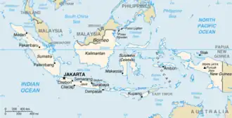 The map of the Indonesian archipelago along with the names of its islands and seas, is estimated to encompass between 17,000 to 18,000 islands scattered across the entire Indonesian archipelago. | |
| Etymology |
|
|---|---|
| Geography | |
| Location | Southeast Asia and Oceania |
| Adjacent to | |
| Total islands | ± 17,000–18,000 islands[1][2] |
| Major islands | |
| Area | 8,300,000 km2 (3,200,000 sq mi) |
| Highest elevation | 4,884 m (16024 ft)[a] |
| Highest point | Puncak Jaya |
| Administration | |
| President | Prabowo Subianto |
| Demographics | |
| Demonym | Indonesians |
| Population | ± 280,000,000 (2023) |
| Population rank | 4 |
| Pop. density | 143/km2 (370/sq mi) |
| Pop. density rank | 88th |
| Languages | See Languages of Indonesia |
| Ethnic groups | See Ethnic groups in Indonesia |
The islands of Indonesia, also known as the Indonesian Archipelago (Kepulauan Indonesia) or Nusantara, may refer either to the islands composing the country of Indonesia or to the geographical groups which include its islands.[3] Indonesia is the world's largest archipelagic state, stretching from Sumatra in Asia to the western part of New Guinea in Oceania.
History
The exact number of islands composing Indonesia varies among definitions and sources. According to the Law No 9/1996 on Maritime Territory of Indonesia, of 17,508 officially listed islands within the territory of the Republic of Indonesia.[4] According to a geospatial survey conducted between 2007 and 2010 by the National Coordinating Agency for Survey and Mapping (Bakorsurtanal), Indonesia has 13,466 islands.[5] However, according to earlier survey in 2002 by National Institute of Aeronautics and Space (LAPAN), the Indonesian archipelago has 18,307 islands,[6] and according to the CIA World Factbook, there are 17,508 islands.[7] The discrepancy of the numbers of Indonesian islands is due to the earlier surveys including "tidal islands"; sandy cays and rocky reefs that appear during low tide and are submerged during high tide. As of 2023, 17,024 island have been named by Geospatial Information Agency and published in Indonesian Gazetteer.[1]

Major islands
- Sunda Islands
- Greater Sunda Islands
- Java, formerly Jawa Dwipa.
- Sumatra, formerly Swarna Dwipa.
- Borneo: divided between the Indonesian region Kalimantan, the country of Brunei and the Malaysian states of Sabah and Sarawak.
- Sulawesi, formerly Celebes.
- Lesser Sunda Islands
- Bali
- Lombok
- Sumbawa
- Flores
- Sumba
- Timor: divided between Indonesian West Timor and the country of East Timor.
- Greater Sunda Islands
- Maluku Islands (Moluccas)
- New Guinea: divided between the Indonesian provinces of Highland Papua, Papua, South Papua, Southwest Papua, Central Papua and West Papua and the country of Papua New Guinea.
List of islands
The following islands are listed by province:
- Panaitan
- Sangiang
- Tinjil
- Umang
- Karimunjawa
- Nusa Kambangan
- Thousand Islands (Kepulauan Seribu)
- Bawean
- Gili Iyang Island
- Kangean Islands
- Madura
- Raas
- Nusa Barong
- Raja Island
- Sempu Island
- Monitor Lizard Island (Pulau Biawak), Indramayu
- Banyak Islands
- Tuangku
- Lasia Island
- Simeulue
- Weh
- Batu Islands
- Berhala on the Strait of Malacca
- Hinako Islands
- Makole Island
- Masa Island
- Nias Islands
- Samosir, Lake Toba
- Mentawai Islands
- North Pagai
- Siberut
- Sipura
- South Pagai
- Pasumpahan
- Sikuai
- Child of Krakatoa (Anak Krakatau)
- Legundi
- Sebesi
- Sebuku
- Basu Island
- Bengkalis
- Padang
- Rangsang
- Rupat
- Tebing Tinggi Island
- Natuna Islands (Kepulauan Natuna)
- Anambas Islands
- Natuna Besar Islands
- South Natuna Islands
- Tambelan Islands
- Badas Islands
- Riau Archipelago
- Batam
- Bintan
- Bulan
- Galang
- Karimun islands
- Great Natuna
- Penyengat
- Great Karimun
- Little Karimun
- Kundur
- Rempang
- Lingga Islands
- Lingga with nearby islands
- Singkep with nearby islands
- Damar
- Baning Island
- Buaya Island
- Burung Island
- Balabalagan Islands
- Derawan Islands
- Kakaban
- Bunyu
- Sebatik: divided between Indonesia and Sabah, East Malaysia
- Tarakan
- Laut
- Laut Kecil Islands
- Sebuku
- Bawal
- Galam
- Karimata Islands
- Karimata
- Maya
- Banggai Islands
- Banggai
- Bowokan Islands (Kepulauan Treko)
- Buka Buka
- Peleng
- Masoni Island
- Simatang Island
- Togian Islands
- Togian
- Tolitoli
- Bangka
- Bunaken
- Lembeh
- Manado Tua
- Nain
- Sangihe Islands
- Nanipa
- Bukide
- Sangir Besar
- Siau
- Tagulandang
- Talaud Islands
- Kabaruan
- Karakelang
- Salibabu
- Talise
- Pabbiring Islands
- Sabalana Islands
- Selayar Islands
- Selayar Island
- Takabonerate Islands
- Tengah Islands
- Buton
- Kabaena
- Muna
- Tukangbesi Islands
- Wakatobi
- Wangiwangi
- Wakatobi
- Wowoni
- Bali
- Menjangan Island
- Nusa Lembongan
- Nusa Penida
- Serangan Island
- Nusa Ceningan
- Alor Islands
- Flores
- Babi Island
- Mules Island
- Komodo
- Gili Lawadarat
- Gili Lawalaut
- Mangiatan Island
- Makasar Island
- Taka Makasar
- Mauwang Island
- Pararambah Island
- Siaba Besar Island
- Siaba Kecil Island
- Mangiatan Island
- Tatawa Island
- Tukoh Pemaroh
- Pararambah Island
- Padar Island
- Batubilah Island
- Padar Kecil Island
- Palu Island
- Pemana Islands
- Rinca
- Gili Motang
- Golo Mori
- Muang Island
- Rohbong Island
- Tukoh Gagak
- Tukoh Rohbongkoe
- Papagaran Besar Island
- Papagaran Kecil Island
- Batu Island
- Mole Island
- Pengah Besar Island
- Pengah Kecil Island
- Batupengah Island
- Rote Island
- Savu
- Solor Islands
- Sumba
- Halura Island
- Timor, divided between Indonesia (West Timor) and the independent nation of East Timor
- Semau Island
- Gili Islands
- Banta Island
- Gili Biaha
- Gili Mimpang
- Gili Selang
- Gili Tepekong
- Lombok
- Medang Island
- Moyo Island
- Menjangan Island
- Sangeang
- Satonda
- Sumbawa
- Aru Islands
- Enu
- Kobroor
- Maikoor
- Trangan
- Wokam
- Babar
- Banda
- Barat Daya Islands
- Damer
- Liran
- Romang
- Wetar
- Boano
- Buru
- Gorong archipelago
- Kai Islands
- Kelang
- Leti Islands
- Lakor
- Leti
- Moa
- Manipa
- Nusa Laut
- Seram
- Ambon
- Osi
- Saparua
- Tanimbar Islands
- Selaru
- Yamdena
- Small volcanic islands in Banda Sea
- Tayandu Islands (Kepulauan Tayando)
- Watubela archipelago
- Bacan, with nearby islands:
- Kasiruta
- Mandioli
- Muari
- Erà Islands
- Halmahera, with nearby islands:
- Morotai, with nearby islands:
- Rau
- Obi Islands, which include:
- Bisa
- Gomumu
- Obi
- Obilatu
- Tobalai
- Sula Islands
Islands near the Indonesian half of New Guinea island.
- Asia Island
- Karas
- Semai
Southwest Papua
- Ayu Islands
- Palau Ayu
- Palau Reni
- Raja Ampat Islands
- Salawati
- Batanta
- Boo Islands
- Fam Islands
- Misool
- Waigeo
- Gam
- Kawe
- Komoran
- Yos Sudarso
- Marauke
See also
- Malay archipelago
- List of Indonesian islands by area
- List of Indonesian islands by population
Notes
- ^ The elevation given here was determined by the 1971–73 Australian Universities' Expedition and is supported by the Seven Summits authorities and modern high resolution radar data. An older but still often quoted elevation of 5,030 metres (16,503 ft) is obsolete.
References
- ^ a b "Jumlah Pulau Resmi di RI Capai 17.024, Masih Ada yang Tanpa Identitas". cnnindonesia.com (in Indonesian). 20 November 2023. Retrieved 19 June 2020.
- ^ "Indonesia at a Glance". kemlu.com (in Indonesian). 20 November 2023.
- ^ "Island Countries Of The World". WorldAtlas.com. Archived from the original on 7 December 2017. Retrieved 10 August 2019.
- ^ Undang-undang RI Nomor 9 Tahun 1996 tentang Perairan Indonesia [Law No 9/1996 on Maritime Territory of Indonesia] (Law 9, Explanatory notes of Law 9/1996) (in Indonesian). People's Representative Council. 1996.
- ^ "Hanya ada 13.466 Pulau di Indonesia". National Geographic Indonesia (in Indonesian). 8 February 2012. Archived from the original on 28 December 2017. Retrieved 11 April 2016.
- ^ Purwanto, Heru, ed. (10 January 2017). "Indonesia to register 14,752 officially named islands with UN". Antara News. Retrieved 19 October 2021.
- ^ CIA World Factbook
Bibliography
- "Indonesia counts its islands before it's too late". Antara. 17 May 2007.
| Sovereign states |
|
|---|---|
| States with limited recognition |
|
| Dependencies and other territories |
|
| |