Cartography of Ukraine

The cartography of Ukraine involves the history of surveying and the construction of maps of Ukraine.
Early maps
Maps of Ukraine have been produced since the late mediaeval period. During the Turkish wars between 1568 and 1918, high-quality French maps were kept as state secrets amid diplomatic negotiations, while 20th-century maps have reflected the region's multiple changes of government.
Ukraine is largely absent from the maps of the Turkish manuscript mapping-tradition that flourished during the reign of the Ottoman Sultan Mehmed II the Conqueror (r. 1444–1446, 1451–1481); the Mediterranean received its own section in world maps,[1]: 5 but typical Turkish maps of the period omitted the Black Sea, and the entire region of the Rus' appeared as just a small portion of Asia between the Caspian and the Mediterranean.[1]: 7
17th century
Two centuries later Guillaume le Vasseur, sieur de Beauplan became one of the more prominent cartographers working with Ukrainian data. His 1639 descriptive map of the region was the first such one produced, and after he published a pair of Ukraine maps of different scale in 1660, his drawings were republished throughout much of Europe.[2] A copy of de Beauplan's maps played a crucial role in negotiations between the Polish-Lithuanian Commonwealth and the Ottoman Empire in 1640; its depiction of the disputed Kodak Fortress was of such quality that the head Polish ambassador, Wojciech Miaskowski, deemed it dangerous to exhibit it to his Turkish counterparts.[3]
Giacomo Cantelli da Vignola's 1684 map of Tartaria d'Europa[4] includes "Vkraina o Paese dei Cossachi de Zaporowa" [Ukraine or the land of the Zaporozhian Cossacks].
18th century
English-language maps of 1769 depicted the Crimean Khanate as part of its suzerain, the Ottoman Empire, with clear boundaries between the Muslim-ruled states in the south and the Christian-ruled states to the north. Another map from the eighteenth century, inscribed in Latin, was careful to depict a small buffer zone between Kiev and the Polish border.[5]
Modern maps
In more recent history, maps of the country have reflected its tumultuous political status and relations with Russia; for example, the city known as "Lvov" (Russian: Львов) during the Soviet era (until 1991) was depicted as "Leopol" or "Lemberg" during its time (1772-1918) in the Habsburg realms, while post-Soviet maps produced in Ukraine have referred to it by its endonym of "Lviv"[5] (Ukrainian: Львів). (Under Polish rule (1272-1772) it went by the Polish name of Lwów).
List
| Year | Original Name | Name in English | Author | Description | Map | |
|---|---|---|---|---|---|---|
| 1154 | Map of al-Idrisi | Abu Abdullah Muhammad al-Idrisi al-Qurtubi al-Hasani al-Sabti | The map of al-Idrisi in 1154 shows not only the territorial placement of Ukraine, but also for the first time the name "Rusia" (meaning Kievan Rus'). The inscriptions on the map include "Ard al Rusia" - the land of Rus' (the territory of Right-bank and Left-bank Ukraine), "muttasil ard al Rusia" - the connected land of Rus', "minal Rusia al tuani" - dependent on Rus'. The rivers - Dnipro, Dniester, Danube - are marked and labeled, as well as Kyiv (Kiau) and other Ukrainian cities. |  | ||
| 1375 | Atles Català | Catalan Atlas (Portolan) | Abraham Cresques | The cartography was done during the decline of the Kingdom of Galicia–Volhynia during the Galicia–Volhynia Wars, as well as the Great Troubles of the Golden Horde. The map shows the cities of Lviv (Ciutà de Leó)[6] and Kyiv (Chiva), as well as the country of Rus' (Rossia) on the right bank of the Dnipro. Lviv is marked as a European city with a flag whose coat of arms appears in the Castilian armorial Book of Knowledge of All Kingdoms. Kyiv is depicted as an independent Asian city; it is located in the lower reaches of the Dnipro.[7] | 
| |
| 1544 | "Cosmographia". Map of the Polish region | Sebastian Münster | Rus (Peremyshl, Lviv, Lutsk, Kyiv), Podolia (Kamianets-Podilskyi, Horodets, Bastarnia), Bessarabia, Scythia, Crimea (Perekop, Kaffa); Muscovy, Pskov region, Tataria; Livonia (Riga), Sarmatia, Lithuania (Vilnius, Hrodna), Prussia (Marienburg, Danzig), Mazovia, Greater Poland, Lesser Poland, Hungary, Wallachia, Moldavia. | 
| ||
| 1550 | Black Sea basin Portolan | Battista Agnese | Rus', Tataria and Muscovy | _2.jpg)
| ||
| 1559 | Black Sea Portolan | Diogo Homem | 
| |||
| 1568 | …dirego della seconda… | Forlani | 
| |||
| 1571 | Tabula Sarmatiae from Strabonis Rerum Geographicarum | Ptolemy's map | Sebastian Münster | European Sarmatia with the cities of Olbia, Heraclea, Theodosia, Claypida and geographical features such as the Carpathian Mountains, the Dnieper (Borysthenes), the Dniester (Tyras), Tauria, the Sea of Azov (Paludes Meotidis), the Black Sea (Ponti Evxini), Amadotian Lake and others. | 
| |
| 1613 | Magni Ducatus Lithuaniae Caeterarumque Regionum Illi Adjacentium . . . Anno 1613 (I) | Radziwiłł map | Hessel Gerritsz, Willem Janszoon Blaeu |
The map shows "Eastern Volhynia, which is also called Ukraine and Nis by others" between Rzhyshchiv and Kaniv in central Podniprovia. One of the earliest cartographic sources with the mention of "Ukraine".[8] | .jpg)
| |
| 1639 | Tabula Geographica Ukrainska | Ukrainian Geographical Map | Guillaume Le Vasseur de Beauplan | Hand-drawn map, became the basis of his General Map of Ukraine. | 
| |
| 1648 | Delineatio Generalis Camporum Desertorum vulgo Ukraina | General Map of the Wild Fields, in common speech Ukraine | Guillaume Le Vasseur de Beauplan | |||
| 1649 | Typus Generalis Vkraine | General description of Ukraine | Jan Janssonius | 
| ||
| 1651 | Delineatio Specialis Et Accurata Ukrainae | Special Map and Accurate of Ukraine | Guillaume Le Vasseur de Beauplan | Derived from the fifth version of his General Map of Ukraine. | 
| |
| 1659—1685 | Ukrainae pars quae Kiovia Palatinatus vulgo dicitur | Ukrainian lands, Kyiv Voivodeship | Guillaume Le Vasseur de Beauplan, Covens & Mortier | 
| ||
| Late 17th century | Ukraine Pars qva Podolia… | Ukrainian lands, Podillia | Covens & Mortier | The Covens map was created based on the map by Beauplan. | 
| |
| Late 17th century | Ukrainae pars quae Barclavia… | Ukrainian lands, Bracław region | Covens & Mortier | Published in Amsterdam. | 
| |
| 1662 | Ukraine Pars qva Pokutia… | Ukrainian lands, Carpathians. | Joan Blaeu | Modern Ivano-Frankivsk Oblast. Created by cartographer Guillaume Le Vasseur de Beauplan. |  | |
| 1665 | Russie Noire | Black Rus' | Nicolas Sanson | Black Rus' (Galicia) | ||
| 1665 | Tartarie Europeenne ou Petite Tartarie… | European Tartaria or Little Tartary | Nicolas Sanson | Tartary, Ukraine - the state of the Cossacks, Muscovy and Poland. | ||
| 1665 | Haute Volhynie, ou Palatinat de Lusuc; tire de la Grande Carte d'Ukraine. | Volyn, so-called Lutsk lands; part of the Great Map of Ukraine | Nicolas Sanson | |||
| 17th century | Vkraina | Ukraine | Wilhelm Pfann | |||
| 1670 | Regni Polonia magni ducatus Lithuania | Kingdom of Poland; Grand Duchy of Lithuania | Carlo Alard | Poland, Lithuania, and Ukraine as part of the Polish-Lithuanian Commonwealth | 
| |
| 1674 | Vkraine ou Pays des Cosaques | Ukraine or State of the Cossacks | Guillaume Sanson | |||
| 1684 | Tartaria d'Europa ouero Piccola Tartaria | European Tartary or Little Tartary | Giacomo Cantelli | Dnieper Ukraine marked as "Ukraine or the land of the Zaporozhian Cossacks" (Vkraina o Paese de Cossachi di Zaporowa). To the east of it is another Ukraine - "Ukraine or the land of the Don Cossacks, dependent on Moscow" (Vkraina ouero Paese de Cossachi Tanaiti Soggetti al Moscouita). |  | |
| 1705 | Королевства Польского и Великого княжества Литовского чертеж | Plan of the Kingdom of Poland and Grand Duchy of Lithuania | Peter Picart | The map depicts the territories of the Grand Duchy of Lithuania. There are also markings for Ukraine (Ꙋkraіna) and Part of Moscow State. |  | |
| 1705 | Le mar noire… Et les pars Cosaques… | The Black Sea... And the Lands of the Cossacks... | Nicolas de Fer | The northern Black Sea coast - the lands of the Cossacks - Ukraine, and Little Tataria. |  | |
| 1710(?) | Ukraine grand pays de la Russie Rouge avec une partie de la Pologne, Moscovie… | Great Country - Ukraine, Red Ruthenia, bordering with Poland, Muscovy, Wallachia... | Pierre Van Der Haeghen; | 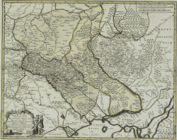 | ||
| 1710 | Ukraina | Ukraine | Abraham Allard | Map of Poland and Muscovy (including Lithuania, Ukraine, Russia, Volhynia, Courland, Crimea, Wallachia, Livonia) |  | |
| 1711 | Ukraine… | Guillaume Delisle | Map of Ukraine, Kiev Voivodeship. | |||
| 1720 | Vkrania que terra Cosaccorvm… | Ukraine - land of the Cossacks | Johann Baptist Homann | Map "Ukraine or Cossack land with neighboring provinces of Wallachia, Moldavia, and Little Tartary" by Johann Baptist Homann, Nuremberg, 1716. Western and central parts of Ukraine are shown. Near UKRANIA is marked as RUSSIA RUBRA. According to one version, the man sitting and smoking a pipe surrounded by associates depicted on the cartouche is Ivan Mazepa. | .jpg) | |
| 1723 | Unnamed map in Travels through Europe, Asia and into parts of Africa | Aubry de La Mottraye | The author served king Charles XII of Sweden, staying with his army in Bender, Moldova during 1709–1713 after their retreat from the 1709 Battle of Poltava. Most details concern western Black Sea coastal towns between Bender on the Dniester and Constantinople (modern Istanbul), with few details on the area he called "UCKRANIA" except "Pultava" (Poltava, marked with crossed swords) on the left bank and a few towns including "Kiow" (modern Kyiv) on the right bank. Mottraye published Travels through Europe, Asia and into parts of Africa in London in 1723 (dedicated to George I), including this map with (dedicated probably to Robert Sutton (diplomat)). | .jpg) | ||
| 1730 | Nova Mappa Maris Nigri… | New map of the Black Sea | Matthäus Seutter | |||
| 1740 | Nova Et Accurata Tartarie Europe Seu Minoris… | European Tartary | Matthäus Seutter | Little Tartary and Ukraine - land of the Cossacks. | 
| |
| 1740 | Nova et accurata Turcicarum et Tartaricarum Provinciarum | Matthäus Seutter | Malo-Tartary and Ukraine - Cossack State. | |||
| 1770 | Amplissima Ucraniae Regio… | Ukraine and regions | Tobias Conrad Lotter | Ukrainian lands | ||
| 1781 | Russia Rossa | Antonio Zatta | Translates to "Dry Rus". According to another version - "Red Rus". | .jpg)
| ||
| 1919 | Carte de Ukraine | A map presented by the delegation of the UNR at the Paris Peace Conference. | 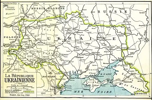
| |||
| 1920 | World Map with the Distribution of Ukrainians | "World Map with the Distribution of Ukrainians" by Georg Hasenko, 1920. |  | |||
| 1928 | Contemporary Division of Eastern Slavs by Language | Modern division of Eastern Slavs by language | Kudryashov K. V. | A map published in the "Russian Historical Atlas" in Moscow, which received the first prize of the TsEKUB and the Central Executive Committee of the USSR. |  |
See also
- Geography of Ukraine
- Maria Vavrychyn
References
- ^ a b Pinto, Karen. "The Maps are the Message: Mehmet II's Patronage of an 'Ottoman Cluster'". Imago Mundi 63.2 (2011): 155-179. DOI: 10.1080/03085694.2011.568703.
- ^ Borschak, Elie. "Beauplan, Guillaume Le Vasseur de". Internet Encyclopedia of Ukraine. Retrieved 20 January 2013.
- ^ Pernal, Andrew B. "Two Newly-Discovered Seventeenth-Century Manuscript Maps of Ukraine". Od Kijowa do Rzymu. Białystok : Instytut Badań nad Dziedzictwem Kulturowym Europy, 2012, 188.
- ^ Tartaria d'Europa
- ^ a b Kendall, Bridget. "Ukraine Maps Chart Crimea's Troubled Past", BBC, 2014-03-13. Accessed 2014-08-11.
- ^ "Panel IV". The Cresques Project. Retrieved 2 August 2025.
The city of Leopolis [Lviv]. Some merchants arrive at this city heading to the Levant via the Sea of La Mancha [North Sea/Baltic Sea] in Flanders.
- ^ Байцар А.Л. (2022). Україна та українці на європейських етнографічних картах.
- ^ "Magni Ducatus Lithuaniae Caeterarumque Regionum Illi Adjacentium . . . Anno 1613 (I)". vkraina.com. Vkraina. Archived from the original on January 16, 2020. Retrieved April 18, 2020.
Literature
- Essar, D. F.; Pernal, A. B. (1982). "Beauplan's "Description d'Ukranie": A Bibliography of Editions and Translations". Harvard Ukrainian Studies. 6 (4). Harvard Ukrainian Research Institute: 485–499. ISSN 0363-5570. JSTOR 41036007. Retrieved 28 July 2024.
- Essar, Dennis F.; Pernal, Andrew B. (1990). "The First Edition (1651) of Beauplan's Description d'Ukranie". Harvard Ukrainian Studies. 14 (1/2). Harvard Ukrainian Research Institute: 84–96. ISSN 0363-5570. JSTOR 41036356. Retrieved 28 July 2024.
External links
- Ukraine on old maps from the National Atlas of Ukraine
- Old maps of Ukraine Historical maps from Old Maps Online