List of waterfalls in Iceland


Iceland is well suited for waterfalls (Icelandic: s. foss, pl. fossar). This Nordic island country lies along the Mid-Atlantic Ridge which separates North America and Europe near where the North Atlantic and Arctic Oceans meet. Frequent rain and snow is caused by its near-Arctic location. Large glaciers exist throughout the country whose summer melts feed many rivers. As a result, it is home to a number of large and powerful waterfalls. It is estimated that there are more than 10,000 waterfalls in Iceland.[1]
North
- Dettifoss is the most powerful waterfall in Iceland.
- Gljúfursárfoss
- Selfoss
- Hafragilsfoss
- Goðafoss
- Aldeyjarfoss
South
- Faxi or Vatnsleysufoss in Tungufljót river
- Foss á Síðu
- Gluggafoss
- Gljúfrafoss
- Gjáin has many small waterfalls
- Gullfoss (Golden Falls)
- Háifoss (High Falls)
- Hjálparfoss
- Kvernufoss
- Merkjárfoss
- Ófærufoss used to be noted for the natural bridge which stood above the falls, but it collapsed in 1993.
- Seljalandsfoss
- Skógafoss (Forest Falls)
- Svartifoss (Black Falls) is one of the many waterfalls of Skaftafell National Park
- Systrafoss, in Kirkjubæjarklaustur
- Þjófafoss on the Merkurhraun lava fields
- Öxarárfoss, at Þingvellir National Park
- Fagrifoss, near Kirkjubæjarklaustur
- Morsárfoss, 228m waterfall formed from the retreat of Morsárjökull that is now Iceland's tallest.[2]
- Urriðafoss
West
- Álafoss
- Barnafossar (the Children's Falls) in Hvítá river
- Glymur in the Hvalfjörður area. At 198m, it was long regarded as the tallest waterfall in Iceland until being surpassed with a new falls by Morsárjökull in 2011.
- Hraunfossar (the Lava Falls) in birchwoods, a stone's throw from Barnafoss.
Westfjords
- Dynjandi, sometimes called Fjallfoss.
East
- Hengifoss
- Litlanesfoss, surrounded by columnar basalt, it is on the way up to Hengifoss
- Fardagafoss near Egilsstaðir
- Gufufoss ("Steam falls") In Seyðisfjörður
- Klifbrekkufossar in Mjóifjörður. A beautiful row of waterfalls
List of waterfalls by height
| Picture | Name | Height | Water body | Region | Community | Coordinates | Comment |
|---|---|---|---|---|---|---|---|

|
Morsárfoss | 227.3 m | Morsá | Austurland | Hornafjörður | 64°06′45″N 16°53′05″W / 64.11241°N 16.884806°W | Discovered in 2007, measured in 2011; |
|
Glymur | 196 m | Botnsá | Vesturland | Hvalfjarðarsveit | 64°23′28″N 21°15′02″W / 64.3911°N 21.2505°W | Considered tallest waterfall until 2011 |

|
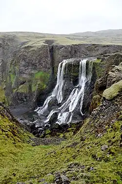
Hengifoss | 128 m[3] | Hengifossá | Austurland | Fljótsdalur | 65°05′44″N 14°53′25″W / 65.095693°N 14.890167°W | Alternative height: 110 m |
|
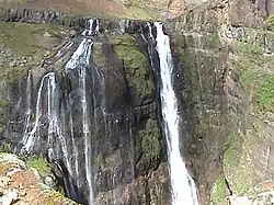
Háifoss | 122 m | Fossá í Þjórsárdal | Suðurland | Skeiða- og Gnúpverjahreppur |
64°12′29″N 19°41′16″W / 64.208°N 19.6877°W | Neighbour of Granni |

|
Granni | 101 m | Fossá í Þjórsárdal | Suðurland | Skeiða- og Gnúpverjahreppur |
64°12′33″N 19°41′00″W / 64.2092°N 19.6832°W | Neighbour of Háifoss |

|
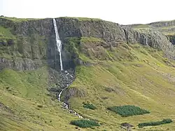
Dynjandi | 100 m | Dynjandisá | Vestfirðir | Vesturbyggð | 65°43′57″N 23°11′56″W / 65.7326°N 23.199°W | Alternative name: Fjallfoss Tallest waterfall of the Westfjords |
.jpg)
|
Rjúkandi | 93 m | Ysta-Rjúkandi | Austurland | Fljótsdalshérað | 65°20′05″N 15°04′55″W / 65.334674°N 15.082054°W | between Egilsstaðir and Mývatn |

|
Foss á Síðu | 82 m | Fossá | Suðurland | Skaftárhreppur | 63°51′21″N 17°52′12″W / 63.855737°N 17.869925°W | close to Kirkjubæjarklaustur |
|
Bjarnafoss | 80 m | Bjarnaá | Vesturland | Snæfellsbær | 64°50′54″N 23°24′12″W / 64.8482°N 23.4033°W | |
|
Fagrifoss | 80 m | Geirlandsá | Suðurland | Skaftárhreppur | 63°52′01″N 18°15′00″W / 63.86694°N 18.2500°W | in Vatnajökull National Park |

|
Skiptárfoss | 80 m | Skiptá | Vestfirðir | Reykhólahreppur Vesturbyggð |
65°36′22″N 22°55′31″W / 65.606013°N 22.925288°W | |

|
Þórðarfoss | 80 m | Þórðara | Suðurland | Rangárþing eystra | 63°43′19″N 19°53′55″W / 63.7220°N 19.8985°W | close to Merkjárfoss |

|
Grundarfoss | 70 m | Grundará | Vesturland | Grundarfjörður | 64°54′32″N 23°13′21″W / 64.9089°N 23.2224°W | at Snæfellsnes |
|
Systrafoss | 69 m | Fossá | Suðurland | Skaftárhreppur | 63°47′09″N 18°03′35″W / 63.7859°N 18.0596°W | close to Kirkjubæjarklaustur |

|
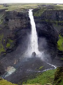
Seljalandsfoss | 65 m | Seljalandsá | Suðurland | Rangárþing eystra | 63°36′56″N 19°59′16″W / 63.6156°N 19.9879°W | |

|
Skógafoss | 62 m | Skógá | Suðurland | Rangárþing eystra | 63°31′56″N 19°30′41″W / 63.5321°N 19.5113°W | |

|
Írárfoss | 60 m | Írá | Suðurland | Rangárþing eystra | 63°34′39″N 19°49′44″W / 63.5776°N 19.828951°W |
See also
- List of waterfalls
 Iceland portal
References
- ^ Icelandorg (October 28, 2023). "Waterfalls in Iceland: Names, Facts, and Features". Iceland.org – Iceland Tours, Car Rentals and Information. Retrieved October 28, 2023.
- ^ "Iceland's Tallest Waterfall to be Named".
- ^ "Hengifoss (Fjotsdalsheidi)". European waterfalls. Retrieved 2020-08-10.
External links
- Iceland's Best Waterfalls
- Iceland Waterfalls
- Photo of Hangifoss
- Photo of Goðafoss
- Photos of Waterfalls in Iceland
- Photos of Skogafoss waterfall, Iceland
| ||