Bardeh, Chaharmahal and Bakhtiari
Bardeh
Persian: بارده | |
|---|---|
Village | |
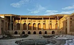 Darab Khan and Mohammad Hasan Khan Bardeh Castle is a historical castle located in the village of Bardeh, Ben County. | |
 Bardeh | |
| Coordinates: 32°34′10″N 50°31′32″E / 32.56944°N 50.52556°E[1] | |
| Country | Iran |
| Province | Chaharmahal and Bakhtiari |
| County | Ben |
| District | Central |
| Rural District | Vardanjan |
| Population (2016)[2] | |
• Total | 2,356 |
| Time zone | UTC+3:30 (IRST) |
Bardeh (Persian: بارده)[a] is a village in, and the capital of, Vardanjan Rural District[b] in the Central District of Ben County, Chaharmahal and Bakhtiari province, Iran.[5] The previous capital of the rural district was the village of Vardanjan,[6] now a city.[7]
Demographics
Ethnicity
The village is populated by Turkic people with a Luri minority.[8]
Population
At the time of the 2006 National Census, the village's population was 2,781 in 662 households, when it was in the former Ben District of Shahrekord County.[9] The following census in 2011 counted 2,534 people in 688 households.[10] The 2016 census measured the population of the village as 2,356 people in 728 households, by which time the district had been separated from the county in the establishment of Ben County. The rural district was transferred to the new Central District.[2]
Climate
| Climate data for Bardeh (elevation: 2394m, 2000-2012 precipitation normals) | |||||||||||||
|---|---|---|---|---|---|---|---|---|---|---|---|---|---|
| Month | Jan | Feb | Mar | Apr | May | Jun | Jul | Aug | Sep | Oct | Nov | Dec | Year |
| Average precipitation mm (inches) | 49.8 (1.96) |
42.3 (1.67) |
46.7 (1.84) |
54.8 (2.16) |
6.4 (0.25) |
0.8 (0.03) |
0.1 (0.00) |
0.0 (0.0) |
0.5 (0.02) |
6.2 (0.24) |
49.9 (1.96) |
59.8 (2.35) |
317.3 (12.48) |
| Source: Chaharmahalmet [11] | |||||||||||||
See also
![]() Iran portal
Iran portal
Notes
- ^ Also romanized as Bārdeh[3]
- ^ Formerly Ben Rural District[4]
References
- ^ OpenStreetMap contributors (28 August 2024). "Bardeh, Vardanjan Rural District, بخش مرکزی [Central District], Ben County, Chaharmahal and Bakhtiyari Province, Iran" (Map). OpenStreetMap (in Persian). Retrieved 28 August 2024.
- ^ a b سرشماري عمومي نفوس و مسكن 1395 : استان چهارمحال و بختیاری [General Population and Housing Census 2016: Chaharmahal and Bakhtiari Province]. مرکز آمار ایران [Statistical Centre of Iran] (in Persian). Archived from the original (Excel) on 24 May 2019. Retrieved 19 December 2022.
- ^ Bardeh can be found at GEOnet Names Server, at this link, by opening the Advanced Search box, entering "-3055451" in the "Unique Feature Id" form, and clicking on "Search Database".
- ^ Habibi, Hassan (26 April 1990) [تاریخ تصویب (Approval date) 1369/02/26 (Iranian Jalali calendar)]. تصویب اصلاحاتی در دهستانهای استان چهار محال و بختیاری [Approval of reforms in rural districts of Chaharmahal and Bakhtiari province]. لام تا کام [Lam ta Kam] (in Persian). وزارت کشور [Ministry of the Interior]. کمیسیون سیاسی دفاعی هیأت دولت [Political Defense Commission of the Government Board]. شناسه [ID] E80123B8-C979-4E5D-9C98-3FB8DCCB1166. شماره دوره [Course number] 69. Archived from the original on 26 August 2025. Retrieved 26 August 2025.
- ^ Rahimi, Mohammad Reza (1 January 2013) [تاریخ ابلاغیه : 1391/10/12 (Date of Resolution: 1391/10/12) (Iranian Jalali calendar)]. تصویبنامه درخصوص تقسیمات کشوری در استان چهارمحال و بختیاری [Resolution on national divisions in Chaharmahal and Bakhtiari province]. مرکز پژوهشهای مجلس شورای اسلامی ایران [Research Center of the Islamic Consultative Assembly of Iran] (in Persian). وزارت کشور [Ministry of the Interior]. هیات وزیران [Council of Ministers]. بختیاری شماره۲۰۰۶۷۱/ت۴۷۶۶۱ه [Notification Number 200671/T47661H]. Archived from the original on 10 January 2013. Retrieved 27 August 2025.
- ^ Mousavi, Mir-Hossein (22 April 1987) [تاریخ تصویب (Approval date) 1366/02/02 (Iranian Jalali calendar)]. ایجاد و تشکیل 8 دهستان شامل روستاها، مزارع و مکانها در شهرستان شهر کرد تابع استان چهار محال و بختیاری [Establishment and formation of eight rural districts including villages, farms and places in Shahrekord County, subordinate to Chaharmahal and Bakhtiari province]. لام تا کام [Lam ta Kam] (in Persian). وزارت کشور [Ministry of the Interior]. هیات وزیران [Council of Ministers]. شناسه [ID] F68A8916-FE1F-44E6-BFC7-A1FE16374F3A. شماره دوره [Course number] 66. Archived from the original on 27 August 2025. Retrieved 27 August 2025.
- ^ Rahimi, Mohammad Reza (30 January 2011) [تاریخ تصویب (Approval date) 1389/11/10 (Iranian Jalali calendar)]. تصویب نامه در خصوص تقسیمات کشوری در استان چهارمحال و بختیاری [Approval regarding national divisions in Chaharmahal and Bakhtiari province]. لام تا کام [Lam ta Kam] (in Persian). وزارت کشور [Ministry of the Interior]. کمیسیون سیاسی دفاعی هیأت دولت [Political Defense Commission of the Government Board]. شماره ابلاغیه 293621/ت45487ک [Notification number 293621/T45487K]. Archived from the original on 16 November 2023. Retrieved 27 August 2025.
- ^ "Language distribution: Chahar Mahal va Bakhtiari Province". Iran Atlas. Retrieved 25 March 2021.
- ^ سرشماري عمومي نفوس و مسكن 1385 : استان چهارمحال و بختیاری [General Population and Housing Census 2006: Chaharmahal and Bakhtiari Province]. مرکز آمار ایران [Statistical Centre of Iran] (in Persian). Archived from the original (Excel) on 20 September 2011. Retrieved 25 September 2022.
- ^ سرشماري عمومي نفوس و مسكن 1390 : استان چهارمحال و بختیاری [General Population and Housing Census 2011: Chaharmahal and Bakhtiari Province]. Iran Data Portal—Syracuse University (in Persian). مرکز آمار ایران [Statistical Centre of Iran]. Archived from the original (Excel) on 16 January 2023. Retrieved 19 December 2022.
- ^ "Bardeh, Precipitation normals" مجموع بارندگي ماهيانه به ميليمتر - بارده. Chaharmahalmet (in Persian). Archived from the original on 16 June 2016. Retrieved 1 March 2025.
Chaharmahal and Bakhtiari province, Iran | |||||||||||||||||||||||
|---|---|---|---|---|---|---|---|---|---|---|---|---|---|---|---|---|---|---|---|---|---|---|---|
| Capital |
|  | |||||||||||||||||||||
| Counties and cities |
| ||||||||||||||||||||||
| Landmarks |
| ||||||||||||||||||||||
| populated places |
| ||||||||||||||||||||||
| Capital |
| ||||||||||||||||||||
|---|---|---|---|---|---|---|---|---|---|---|---|---|---|---|---|---|---|---|---|---|---|
| Districts |
| ||||||||||||||||||||
| References | "Rural Districts of Iran: Chaharmahal and Bakhtiari - 2021". amar.org.ir (in Persian). Statistical Center of Iran. Retrieved 29 July 2025. | ||||||||||||||||||||