Vardanjan, Iran
Vardanjan
Persian: وردنجان | |
|---|---|
City | |
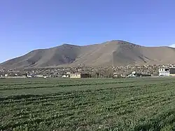 City of Vardanjan, Iran | |
 Vardanjan | |
| Coordinates: 32°28′31″N 50°46′05″E / 32.47528°N 50.76806°E[1][2] | |
| Country | Iran |
| Province | Chaharmahal and Bakhtiari |
| County | Ben |
| District | Central |
| Established as a city | 2011[3] |
| Population (2016)[4] | |
• Total | 4,456 |
| Time zone | UTC+3:30 (IRST) |
Vardanjan (Persian: وردنجان)[a] is a city in the Central District of Ben County, Chaharmahal and Bakhtiari province, Iran. It was the capital of Ben Rural District[6][b] until its capital was transferred to the village of Bardeh.[8]
Demographics
Ethnicity
The city is populated by Persians.[9][10]
Population
At the time of the 2006 National Census, the city's population was 4,262 in 1,023 households, when it was a village in Vardanjan Rural District[c] of the former Ben District in Shahrekord County.[11] The following census in 2011 counted 4,324 people in 1,179 households,[12] by which time the village had been elevated to the status of a city.[3] The 2016 census measured the population of the city as 4,456 people in 1,329 households,[4] when the district had been separated from the county in the establishment of Ben County. Vardanjan and the rural district were transferred to the new Central District.[8]
See also
![]() Iran portal
Iran portal
Notes
- ^ Also romanized as Vardanjān; also known as Vardangūn, Vardaniān, and Wardangun[5]
- ^ Renamed Vardanjan Rural District[7]
- ^ Formerly Ben Rural District[7]
References
- ^ OpenStreetMap contributors (28 August 2024). "Vardanjan, بخش مرکزی [Central District], Ben County, Chaharmahal and Bakhtiyari Province, Iran" (Map). OpenStreetMap (in Persian). Retrieved 28 August 2024.
- ^ "FQG9+467 Vardanjan, Chaharmahal and Bakhtiari Province, Iran" (Map). Google Maps. Retrieved 27 August 2025.
- ^ a b Rahimi, Mohammad Reza (30 January 2011) [تاریخ تصویب (Approval date) 1389/11/10 (Iranian Jalali calendar)]. تصویب نامه در خصوص تقسیمات کشوری در استان چهارمحال و بختیاری [Approval regarding national divisions in Chaharmahal and Bakhtiari province]. لام تا کام [Lam ta Kam] (in Persian). وزارت کشور [Ministry of the Interior]. کمیسیون سیاسی دفاعی هیأت دولت [Political Defense Commission of the Government Board]. شماره ابلاغیه 293621/ت45487ک [Notification number 293621/T45487K]. Archived from the original on 16 November 2023. Retrieved 27 August 2025.
- ^ a b سرشماري عمومي نفوس و مسكن 1395 : استان چهارمحال و بختیاری [General Population and Housing Census 2016: Chaharmahal and Bakhtiari Province]. مرکز آمار ایران [Statistical Centre of Iran] (in Persian). Archived from the original (Excel) on 24 May 2019. Retrieved 19 December 2022.
- ^ Vardanjan can be found at GEOnet Names Server, at this link, by opening the Advanced Search box, entering "-3088157" in the "Unique Feature Id" form, and clicking on "Search Database".
- ^ Mousavi, Mir-Hossein (22 April 1987) [تاریخ تصویب (Approval date) 1366/02/02 (Iranian Jalali calendar)]. ایجاد و تشکیل 8 دهستان شامل روستاها، مزارع و مکانها در شهرستان شهر کرد تابع استان چهار محال و بختیاری [Establishment and formation of eight rural districts including villages, farms and places in Shahrekord County, subordinate to Chaharmahal and Bakhtiari province]. لام تا کام [Lam ta Kam] (in Persian). وزارت کشور [Ministry of the Interior]. هیات وزیران [Council of Ministers]. شناسه [ID] F68A8916-FE1F-44E6-BFC7-A1FE16374F3A. شماره دوره [Course number] 66. Archived from the original on 27 August 2025. Retrieved 27 August 2025.
- ^ a b Habibi, Hassan (26 April 1990) [تاریخ تصویب (Approval date) 1369/02/26 (Iranian Jalali calendar)]. تصویب اصلاحاتی در دهستانهای استان چهار محال و بختیاری [Approval of reforms in rural districts of Chaharmahal and Bakhtiari province]. لام تا کام [Lam ta Kam] (in Persian). وزارت کشور [Ministry of the Interior]. کمیسیون سیاسی دفاعی هیأت دولت [Political Defense Commission of the Government Board]. شناسه [ID] E80123B8-C979-4E5D-9C98-3FB8DCCB1166. شماره دوره [Course number] 69. Archived from the original on 26 August 2025. Retrieved 26 August 2025.
- ^ a b Rahimi, Mohammad Reza (1 January 2013) [تاریخ ابلاغیه : 1391/10/12 (Date of Resolution: 1391/10/12) (Iranian Jalali calendar)]. تصویبنامه درخصوص تقسیمات کشوری در استان چهارمحال و بختیاری [Resolution on national divisions in Chaharmahal and Bakhtiari province]. مرکز پژوهشهای مجلس شورای اسلامی ایران [Research Center of the Islamic Consultative Assembly of Iran] (in Persian). وزارت کشور [Ministry of the Interior]. هیات وزیران [Council of Ministers]. بختیاری شماره۲۰۰۶۷۱/ت۴۷۶۶۱ه [Notification Number 200671/T47661H]. Archived from the original on 10 January 2013. Retrieved 27 August 2025.
- ^ "Language distribution: Chahar Mahal va Bakhtiari Province". Iran Atlas. Retrieved 25 March 2021.
- ^ Anonby, Erik. "Atlas of the Languages of Iran: A working classification". Iran Atlas. Retrieved 27 March 2021.
- ^ سرشماري عمومي نفوس و مسكن 1385 : استان چهارمحال و بختیاری [General Population and Housing Census 2006: Chaharmahal and Bakhtiari Province]. مرکز آمار ایران [Statistical Centre of Iran] (in Persian). Archived from the original (Excel) on 20 September 2011. Retrieved 25 September 2022.
- ^ سرشماري عمومي نفوس و مسكن 1390 : استان چهارمحال و بختیاری [General Population and Housing Census 2011: Chaharmahal and Bakhtiari Province]. Iran Data Portal—Syracuse University (in Persian). مرکز آمار ایران [Statistical Centre of Iran]. Archived from the original (Excel) on 16 January 2023. Retrieved 19 December 2022.
Chaharmahal and Bakhtiari province, Iran | |||||||||||||||||||||||
|---|---|---|---|---|---|---|---|---|---|---|---|---|---|---|---|---|---|---|---|---|---|---|---|
| Capital |
|  | |||||||||||||||||||||
| Counties and cities |
| ||||||||||||||||||||||
| Landmarks |
| ||||||||||||||||||||||
| populated places |
| ||||||||||||||||||||||
| Capital |
| ||||||||||||||||||||
|---|---|---|---|---|---|---|---|---|---|---|---|---|---|---|---|---|---|---|---|---|---|
| Districts |
| ||||||||||||||||||||
| References | "Rural Districts of Iran: Chaharmahal and Bakhtiari - 2021". amar.org.ir (in Persian). Statistical Center of Iran. Retrieved 29 July 2025. | ||||||||||||||||||||