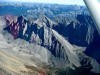
The Kananaskis Range is a mountain range west of the Kananaskis River in the Continental Ranges of the Canadian Rockies. Many of the peaks are named after ships and people involved in the Battle of Jutland.
Mount Bogart is named after D.B. Dowling. Bogart was his mother's maiden name and his middle name. D.B. Dowling surveyed the area in the early 1900s for the Geographical Society of Canada.[5] Tower was named after Francis George Towers an early homesteader of the region. Mt McDougal another early homesteader Archie McDougal of Carstairs. Mts. Evans Thomas named after Thomas Oldham Evans an early homesteader.
List of mountains
Peaks of this range include:
| Name |
Elevation |
Prominence
|
Coordinates
|
| m |
ft |
m |
ft
|
| Mount Galatea
|
3,185
|
10,449 |
1,280
|
4,200
|
50°50′23″N 115°16′26″W / 50.83972°N 115.27389°W / 50.83972; -115.27389
|
| Wind Mountain
|
3,153
|
10,344 |
745
|
2,444
|
50°57′15″N 115°14′46″W / 50.95417°N 115.24611°W / 50.95417; -115.24611
|
| Mount Bogart
|
3,144
|
10,315 |
492
|
1,614
|
50°54′42″N 115°14′35″W / 50.91167°N 115.24306°W / 50.91167; -115.24306
|
| The Tower
|
3,124
|
10,249 |
618
|
2,028
|
50°51′24.1″N 115°17′24.0″W / 50.856694°N 115.290000°W / 50.856694; -115.290000
|
| Mount Sparrowhawk
|
3,121
|
10,240 |
256
|
840
|
50°56′26″N 115°15′57″W / 50.94056°N 115.26583°W / 50.94056; -115.26583
|
| Mount Lougheed
|
3,107
|
10,194 |
242
|
794
|
50°57′56″N 115°15′45″W / 50.96556°N 115.26250°W / 50.96556; -115.26250
|
| Mount Chester
|
3,054
|
10,020 |
341
|
1,119
|
50°48′24″N 115°15′47″W / 50.80667°N 115.26306°W / 50.80667; -115.26306
|
| Mount James Walker
|
3,035
|
9,957 |
322
|
1,056
|
50°48′18″N 115°13′12″W / 50.80500°N 115.22000°W / 50.80500; -115.22000
|
| The Fortress
|
3,000
|
9,800 |
287
|
942
|
50°49′40″N 115°14′36″W / 50.82778°N 115.24333°W / 50.82778; -115.24333
|
| Gusty Peak
|
3,000
|
9,800 |
226
|
741
|
50°49′50″N 115°15′31″W / 50.83056°N 115.25861°W / 50.83056; -115.25861
|
| Mount Inflexible
|
3,000
|
9,800 |
379
|
1,243
|
50°46′54″N 115°12′25″W / 50.78167°N 115.20694°W / 50.78167; -115.20694
|
| Mount Engadine
|
2,970
|
9,740 |
320
|
1,050
|
50°51′54″N 115°18′40″W / 50.86500°N 115.31111°W / 50.86500; -115.31111
|
| Mount Kidd
|
2,958
|
9,705 |
535
|
1,755
|
50°53′37″N 115°11′23″W / 50.89361°N 115.18972°W / 50.89361; -115.18972
|
| Mount Buller
|
2,805
|
9,203 |
270
|
890
|
50°57′15″N 115°14′46″W / 50.95417°N 115.24611°W / 50.95417; -115.24611
|
| Mount Lawson
|
2,795
|
9,170 |
113
|
371
|
50°53′25″N 115°18′50″W / 50.89028°N 115.31389°W / 50.89028; -115.31389
|
| Mount Kent
|
2,637
|
8,652 |
46
|
151
|
|
| Mount Lorette
|
2,487
|
8,159 |
49
|
161
|
50°59′11″N 115°8′1″W / 50.98639°N 115.13361°W / 50.98639; -115.13361
|
| Pigeon Mountain
|
2,394
|
7,854 |
393
|
1,289
|
51°1′42″N 115°12′24″W / 51.02833°N 115.20667°W / 51.02833; -115.20667
|
| Mary Barclay's Mountain
|
2,260
|
7,410 |
160
|
520
|
50°59′58″N 115°6′15″W / 50.99944°N 115.10417°W / 50.99944; -115.10417
|
References
External links
|
|---|
| Ranges | |
|---|
| Mountains | |
|---|
| Passes |
- Abbot
- Athabasca
- Bush
- Carcajou
- Crowsnest
- Elbow
- Elk
- Fortress
- Fraser
- Highwood
- Howse
- Jarvis
- Kananaskis
- Kicking Horse
- Monkman
- Muncho
- North Kananaskis
- Palliser
- Pine
- Simpson
- Sinclair
- Summit
- Sunwapta
- Tonquin
- Vermilion
- Wapiti
- White Man
- Yellowhead
|
|---|
| Glaciers |
- Athabasca
- Bow
- Columbia Icefield
- Crowfoot
- Hector
- Peyto
- Saskatchewan
- Vulture
- Wapta
- Waputik Icefield
|
|---|
| Rivers | see List of rivers of the Canadian Rockies and Category:Rivers of the Canadian Rockies |
|---|
| Peoples |
- Mountain Stoney
- Mountain Metis
|
|---|
Parks and
protected areas | | International |
- Canadian Rocky Mountain Parks World Heritage Site
- Waterton Biosphere Reserve
- Waterton-Glacier International Peace Park
|
|---|
| National |
- Parks
- Banff
- Jasper
- Kootenay
- Yoho
- Waterton Lakes
- Historic Sites
- Jasper House
- Jasper Park Information Centre
- Yellowhead Pass
- Athabasca Pass
- Howse Pass
- Kootenae House
- Kicking Horse Pass
- Skoki Ski Lodge
- Twin Falls Tea House
- Abbot Pass Refuge Cabin
- Cave and Basin
- Banff Park Museum
- Sulphur Mountain Cosmic Ray Station
- First Oil Well in Western Canada
|
|---|
| Provincial (AB) |
- Parks
- Bow Valley
- Bragg Creek
- Elbow-Sheep
- Ghost River
- Kananaskis
- Peter Lougheed
- Sheep River
- Siffleur
- Spray Valley
- White Goat
- Willmore
- Historic Sites
- Frank Slide
|
|---|
| Provincial (BC) |
- Akamina-Kishinena
- Close To The Edge
- Dune Za Keyih (Frog-Gataga)
- Elk Lakes
- Graham-Laurier
- Hamber
- Height of the Rockies
- Hole-in-the-Wall
- Kakwa
- Kikomun Creek
- Kwadacha
- Mount Assiniboine
- Mount Fernie
- Mount Robson
- Muncho Lake
- Northern Rocky Mountains
- Pine Le Moray
- Stone Mountain
- Muskwa-Kechika
|
|---|
|
|---|
| Ski resorts |
- Castle Mountain
- Fernie
- Fortress Mountain
- Lake Louise
- Little Mac
- Marmot Basin
- Mount Norquay
- Nakiska
- Powder King
- Sunshine Village
|
|---|
| Communities |
- Banff
- Canmore
- Crowsnest Pass
- Elkford
- Fernie
- Field
- Jasper
- Lake Louise
- Sparwood
- Tumbler Ridge
- Valemount
- Waterton Park
|
|---|
Ecozone and
ecoregions |
- CEC ecozones
- WWF ecoregions
- Alberta Mountain forests
- Alberta–British Columbia foothills forests
- North Central Rockies forest
|
|---|
- See also
- Geography portal
- Canada portal
|
 Media related to Kananaskis Range at Wikimedia Commons