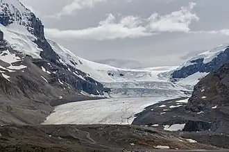
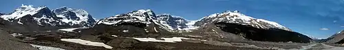
Mount Athabasca, Mount Andromeda, Athabasca Glacier, Snow Dome, Dome Glacier and Mount Kitchener The Winston Churchill Range is a mountain range in the central section of the Park Ranges of the Canadian Rockies located in Jasper National Park.[ 5]
The eastern boundary of the range begins on the western side of Sunwapta River from the Jasper and Banff boundary and extends north to Sunwapta Falls. The western boundary of the range is defined by the Athabasca River valley to the east of Warwick Mountain. The valley narrows as it approaches the Continental Divide , and separates Mt. Columbia from Mt. King Edward , the latter of which is not part of the range.
List of mountains
This range includes the following mountains and peaks:
Mountain / Peak
Elevation
Prominence
FA
Coordinates
m
ft
m
ft
Mount Columbia
3,747
12,293
2,383
7,818
1902
52°8′51″N 117°26′26″W / 52.14750°N 117.44056°W / 52.14750; -117.44056
North Twin Peak
3,730
12,240
1,010
3,310
1923
52°13′25″N 117°26′3″W / 52.22361°N 117.43417°W / 52.22361; -117.43417
Mount Alberta
3,619
11,873
819
2,687
1925
52°17′14″N 117°28′37″W / 52.28722°N 117.47694°W / 52.28722; -117.47694
South Twin Peak
3,566
11,699
341
1,119
1924
52°12′14″N 117°26′5″W / 52.20389°N 117.43472°W / 52.20389; -117.43472
Mount Kitchener
3,505
11,499
280
920
1927
52°13′3″N 117°19′12″W / 52.21750°N 117.32000°W / 52.21750; -117.32000
Snow Dome
3,456
11,339
171
561
1898
52°11′17″N 117°19′1″W / 52.18806°N 117.31694°W / 52.18806; -117.31694
Stutfield Peak
3,450
11,320
290
950
1927
52°14′18″N 117°24′27″W / 52.23833°N 117.40750°W / 52.23833; -117.40750
Mount Woolley
3,405
11,171
565
1,854
1925
52°17′50″N 117°25′31″W / 52.29722°N 117.42528°W / 52.29722; -117.42528
Mount Cromwell
3,380
11,090
360
1,180
1936
52°16′8″N 117°23′35″W / 52.26889°N 117.39306°W / 52.26889; -117.39306
Diadem Peak
3,371
11,060
211
692
1898
52°18′38″N 117°25′15″W / 52.31056°N 117.42083°W / 52.31056; -117.42083
Mount Engelhard
3,270
10,730
210
690
1930
52°16′31″N 117°24′25″W / 52.27528°N 117.40694°W / 52.27528; -117.40694
Mount Smythe
3,246
10,650
420
1,380
1951
52°21′20″N 117°28′30″W / 52.35556°N 117.47500°W / 52.35556; -117.47500
Mount GEC
3,220
10,560
400
1,300
1948
52°20′11″N 117°27′0″W / 52.33639°N 117.45000°W / 52.33639; -117.45000
Mushroom Peak
3,210
10,530
270
890
1947
52°18′42″N 117°23′50″W / 52.31167°N 117.39722°W / 52.31167; -117.39722
Mount Nelson
3,180
10,430
240
790
1951
52°20′46″N 117°28′10″W / 52.34611°N 117.46944°W / 52.34611; -117.46944
Thorington Tower
3,155
10,351
275
902
1967
52°21′27″N 117°30′10″W / 52.35750°N 117.50278°W / 52.35750; -117.50278
Mount Palmer
3,150
10,330
270
890
1953
52°21′10″N 117°31′14″W / 52.35278°N 117.52056°W / 52.35278; -117.52056
Gong Peak
3,120
10,240
280
920
1936
52°22′11″N 117°27′33″W / 52.36972°N 117.45917°W / 52.36972; -117.45917
Mount Weiss
3,120
10,240
210
690
1971
52°23′28″N 117°28′30″W / 52.39111°N 117.47500°W / 52.39111; -117.47500
Mount Adam Joachim
3,090
10,140
440
1,440
1938
52°24′16″N 117°31′40″W / 52.40444°N 117.52778°W / 52.40444; -117.52778
Mount K2
3,090
10,140
Unk
52°13′30″N 117°17′31″W / 52.22500°N 117.29194°W / 52.22500; -117.29194
Mount Mitchell
3,040
9,970
183
600
1970
52°24′12″N 117°30′13″W / 52.40333°N 117.50361°W / 52.40333; -117.50361
Mount Morden Long
3,040
9,970
360
1,180
Unk
52°25′21″N 117°32′17″W / 52.42250°N 117.53806°W / 52.42250; -117.53806
Mount McGuire
3,030
9,940
130
430
1971
52°22′28″N 117°27′7″W / 52.37444°N 117.45194°W / 52.37444; -117.45194
Mount Confederation
2,969
9,741
429
1,407
1947
52°24′13″N 117°34′35″W / 52.40361°N 117.57639°W / 52.40361; -117.57639
Little Alberta
2,956
9,698
250
820
1924
52°16′26″N 117°26′17″W / 52.27389°N 117.43806°W / 52.27389; -117.43806
References
Ranges Mountains Passes
Abbot
Athabasca
Bush
Carcajou
Crowsnest
Elbow
Elk
Fortress
Fraser
Highwood
Howse
Jarvis
Kananaskis
Kicking Horse
Monkman
Muncho
North Kananaskis
Palliser
Pine
Simpson
Sinclair Summit
Sunwapta
Tonquin
Vermilion
Wapiti
White Man
Yellowhead Glaciers
Athabasca
Bow
Columbia Icefield
Crowfoot
Hector
Peyto
Saskatchewan
Vulture
Wapta
Waputik Icefield Rivers see List of rivers of the Canadian Rockies and Category:Rivers of the Canadian Rockies
Peoples
Mountain Stoney
Mountain Metis Parks and
International
Canadian Rocky Mountain Parks World Heritage Site
Waterton Biosphere Reserve
Waterton-Glacier International Peace Park National
Parks
Banff Jasper
Kootenay
Yoho
Waterton Lakes Historic Sites
Jasper House
Jasper Park Information Centre
Yellowhead Pass
Athabasca Pass
Howse Pass
Kootenae House
Kicking Horse Pass
Skoki Ski Lodge
Twin Falls Tea House
Abbot Pass Refuge Cabin
Cave and Basin
Banff Park Museum
Sulphur Mountain Cosmic Ray Station
First Oil Well in Western Canada Provincial (AB)
Parks
Bow Valley
Bragg Creek
Elbow-Sheep
Ghost River
Kananaskis
Peter Lougheed
Sheep River
Siffleur
Spray Valley
White Goat
Willmore Historic Sites
Frank Slide Provincial (BC)
Akamina-Kishinena
Close To The Edge
Dune Za Keyih (Frog-Gataga)
Elk Lakes
Graham-Laurier
Hamber
Height of the Rockies
Hole-in-the-Wall
Kakwa
Kikomun Creek
Kwadacha
Mount Assiniboine
Mount Fernie
Mount Robson
Muncho Lake
Northern Rocky Mountains
Pine Le Moray
Stone Mountain
Muskwa-Kechika
Ski resorts
Castle Mountain
Fernie
Fortress Mountain
Lake Louise
Little Mac
Marmot Basin
Mount Norquay
Nakiska
Powder King
Sunshine Village Communities
Banff
Canmore
Crowsnest Pass
Elkford
Fernie
Field
Jasper
Lake Louise
Sparwood
Tumbler Ridge
Valemount
Waterton Park Ecozone and
CEC ecozones WWF ecoregions Alberta Mountain forests
Alberta–British Columbia foothills forests
North Central Rockies forest
See also
Geography portal
Canada portal