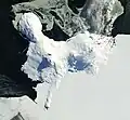
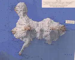
Mūmū Nunatak (77°27′S 169°4′E / 77.450°S 169.067°E / -77.450; 169.067) is a nunatak in the north part of Kyle Hills, Ross Island. The feature is 2 nautical miles (3.7 km) west-southwest of Towle Point and 0.6 nautical miles (1.1 km) inland from steep cliffs that form the northeast edge of the island. The name Mūmū (meaning boisterous wind) is one of several Maori wind names applied by New Zealand Geographic Board (NZGB) in this area.
 This article incorporates public domain material from "Mūmū Nunatak". Geographic Names Information System. United States Geological Survey.
Ross Island |
|---|
Structures
and bases |
- Discovery Hut
- Lower Erebus Hut
- Arrival Heights Laboratory
- McMurdo Station
- Scott Base
- Scott's Hut
- Shackleton's Hut
- World Park Base
| |
|---|
Elevated
features | | Mountains | |
|---|
| Volcanoes | |
|---|
| Hills | |
|---|
| Nunataks | |
|---|
|
|---|
Inland
features | | Cliffs | |
|---|
| Glaciers | |
|---|
| Lakes |
- Algal Lake
- Blue Lake
- Clear Lake
- Coast Lake
- Deep Lake
- Island Lake
- Pony Lake
- Skua Lake
- Starr Lake
- Sunk Lake
- Terrace Lake
|
|---|
| Ridges | |
|---|
Other inland
features | |
|---|
|
|---|
Coastal
features | | Bays |
- Backdoor Bay
- Erebus Bay
- Fog Bay, Antarctica
- Lewis Bay
- Turks Head Bay
- Windless Bight
- Winter Quarters Bay
- Wohlschlag Bay
|
|---|
| Headlands |
- Cape Barne
- Cape Bird
- Cape Crozier
- Dufek Head
- Cape Evans
- Flagstaff Point
- Harrison Bluff
- Hut Point Peninsula
- Keys Point
- Cape MacKay
- Micou Point
- Newport Point
- Cape Royds
- Cape Tennyson
- Terror Point
- Towle Point
- Tryggve Point
- Turks Head
- Varcoe Headland
- Wyandot Point
|
|---|
Other coastal
features |
- Caughley Beach
- McDonald Beach
- McMurdo Ice Shelf
- Waipuke Beach
- Williamson Rock
|
|---|
|
|---|