Sarteshniz
Sarteshniz
Persian: سرتشنيز | |
|---|---|
Village | |
 Gorz-e-Rostam in June 2015 | |
 Sarteshniz | |
| Coordinates: 32°06′35″N 50°53′06″E / 32.10972°N 50.88500°E[1] | |
| Country | Iran |
| Province | Chaharmahal and Bakhtiari |
| County | Kiar |
| District | Kiar-e Sharqi |
| Rural District | Kiar-e Bala |
| Elevation | 2,019 m (6,624 ft) |
| Population (2016)[2] | |
• Total | 2,919 |
| Time zone | UTC+3:30 (IRST) |
Sarteshniz (Persian: سرتشنيز)[a] is a village in, and the capital of, Kiar-e Bala Rural District in Kiar-e Sharqi District of Kiar County, Chaharmahal and Bakhtiari province, Iran.[4]
Demographics
Ethnicity
The village is populated by Persians who speak the Shirazi dialect.[5]
Population
At the time of the 2006 National Census, the village's population was 2,959 in 634 households, when it was in Kiar-e Sharqi Rural District[b] of the former Kiar District in Shahrekord County.[7] The following census in 2011 counted 3,055 people in 823 households,[8] by which time the district had been separated from the county in the establishment of Kiar County. The rural district was transferred to the new Central District.[9] The 2016 census measured the population of the village as 2,919 people in 856 households.[2]
In 2023, the rural district was separated from the district in the formation of Kiar-e Sharqi District. Sarteshniz was transferred to Kiar-e Bala Rural District created in the new district.[4]
Tourist attractions
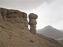
Gorz-e-Rostam (Tana) Cave (گرز رستم) is a geological phenomenon located to the north of Sarteshniz.
Industry
The village's sole industrial complex is the Kiar Flour Production Company south of the village. The factory is responsible for providing the eastern region of the province with numerous types of flour.
See also
![]() Iran portal
Iran portal
Notes
- ^ Also romanized as Sar-e Teshnīz and Sarteshnīz; also known as Sar-i-Tīshnīz[3]
- ^ Formerly Dastgerd Rural District[6]
References
- ^ OpenStreetMap contributors (30 August 2024). "سرتشنیز, دهستان کیارشرقی, بخش مرکزی [Sarteshniz, Kiar-e Sharqi Rural District, Central District], Kiar County, Chaharmahal and Bakhtiyari Province, Iran" (Map). OpenStreetMap (in Persian). Retrieved 30 August 2024.
- ^ a b سرشماري عمومي نفوس و مسكن 1395 : استان چهارمحال و بختیاری [General Population and Housing Census 2016: Chaharmahal and Bakhtiari Province]. مرکز آمار ایران [Statistical Centre of Iran] (in Persian). Archived from the original (Excel) on 24 May 2019. Retrieved 19 December 2022.
- ^ Sarteshniz can be found at GEOnet Names Server, at this link, by opening the Advanced Search box, entering "-3083073" in the "Unique Feature Id" form, and clicking on "Search Database".
- ^ a b Mokhber, Mohammad (16 August 2023) [شماره ۹۰۵۰۷/ت ۵۸۵۴۹ هـ ـ ۱۴۰۲/۵/۲۵ (No. 90507/T 58549 AH - 1402/5/25) (Iranian Jalali calendar)]. تصویبنامه در خصوص تقسیمات کشوری در استانهای اردبیل، چهارمحال و بختیاری، خوزستان، سیستان و بلوچستان، مرکزی و همدان [Resolution on the national divisions in the provinces of Ardabil, Chaharmahal and Bakhtiari, Khuzestan, Sistan and Baluchestan, Markazi and Hamadan]. پژوهشکده حقوقی شهر دانش [Shahr Danesh Law Research Institute] (in Persian). وزارت کشور [Ministry of the Interior]. هیات وزیران [Council of Ministers]. شماره ۹۰۵۰۷/ت ۵۸۵۴۹ هـ ـ [No. 90507/T 58549 AH]. Archived from the original on 30 May 2024. Retrieved 31 August 2025.
- ^ "Language distribution: Chahar Mahal va Bakhtiari Province". Iran Atlas. Retrieved 25 March 2021.
- ^ Habibi, Hassan (26 April 1990) [تاریخ تصویب (Approval date) 1369/02/26 (Iranian Jalali calendar)]. تصویب اصلاحاتی در دهستانهای استان چهار محال و بختیاری [Approval of reforms in rural districts of Chaharmahal and Bakhtiari province]. لام تا کام [Lam ta Kam] (in Persian). وزارت کشور [Ministry of the Interior]. کمیسیون سیاسی دفاعی هیأت دولت [Political Defense Commission of the Government Board]. شناسه [ID] E80123B8-C979-4E5D-9C98-3FB8DCCB1166. شماره دوره [Course number] 69. Archived from the original on 26 August 2025. Retrieved 26 August 2025.
- ^ سرشماري عمومي نفوس و مسكن 1385 : استان چهارمحال و بختیاری [General Population and Housing Census 2006: Chaharmahal and Bakhtiari Province]. مرکز آمار ایران [Statistical Centre of Iran] (in Persian). Archived from the original (Excel) on 20 September 2011. Retrieved 25 September 2022.
- ^ سرشماري عمومي نفوس و مسكن 1390 : استان چهارمحال و بختیاری [General Population and Housing Census 2011: Chaharmahal and Bakhtiari Province]. Iran Data Portal—Syracuse University (in Persian). مرکز آمار ایران [Statistical Centre of Iran]. Archived from the original (Excel) on 16 January 2023. Retrieved 19 December 2022.
- ^ Davoodi, Parviz (21 October 2007) [تاریخ تصویب (Approval date) 1386/07/29 (Iranian Jalali calendar)]. تصویبنامه وزرای عضو کمیسیون سیاسی- دفاعی هیئت دولت در خصوص برخی تغییرات و تقسیمات کشوری در استان چهار محال و بختیاری [Approval of the Ministers of the Political Defense Commission of the Government Board regarding some changes and national divisions in Chaharmahal and Bakhtiari province]. لام تا کام [Lam ta Kam] (in Persian). وزارت کشور [Ministry of the Interior]. کمیسیون سیاسی دفاعی هیأت دولت [Political Defense Commission of the Government Board]. شناسه [ID] 2773B618-ABF2-4EA2-A9B9-33054C181C06. Archived from the original on 26 August 2025. Retrieved 26 August 2025.
Chaharmahal and Bakhtiari province, Iran | |||||||||||||||||||||||
|---|---|---|---|---|---|---|---|---|---|---|---|---|---|---|---|---|---|---|---|---|---|---|---|
| Capital |
|  | |||||||||||||||||||||
| Counties and cities |
| ||||||||||||||||||||||
| Landmarks |
| ||||||||||||||||||||||
| populated places |
| ||||||||||||||||||||||
| Capital | |||||||||||||||||||||||
|---|---|---|---|---|---|---|---|---|---|---|---|---|---|---|---|---|---|---|---|---|---|---|---|
| Districts |
| ||||||||||||||||||||||