Hung Hom
| Hung Hom | |||||||||||||||||||
|---|---|---|---|---|---|---|---|---|---|---|---|---|---|---|---|---|---|---|---|
| Traditional Chinese | 紅磡 | ||||||||||||||||||
| Simplified Chinese | 红磡 | ||||||||||||||||||
| Cantonese Yale | Hùhngham | ||||||||||||||||||
| Literal meaning | "Red Cliff" | ||||||||||||||||||
| |||||||||||||||||||
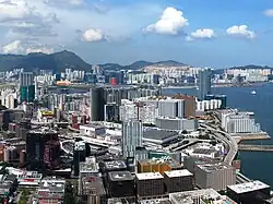


Hung Hom (紅磡, Cantonese pronunciation: [hȍŋ hɐ̄m]) is an area in the southeast of Kowloon Peninsula, Hong Kong. Including the areas of Whampoa, Tai Wan, Hok Yuen, Lo Lung Hang and No. 12 Hill are administratively part of the Kowloon City District, with a portion west of Hung Hom Bay in the Yau Tsim Mong District. Hung Hom serves mainly residential purposes, but it is mixed with some industrial buildings in the north.
Geography
Hung Hom is in the southeast of the Kowloon Peninsula. It is bordered by Victoria Harbour in the south, King's Park in the west, No. 12 Hill, Hok Yuen and the valley Lo Lung Hang in the north.
History
Originally, Hung Hom was much smaller than the present-day context. Hung Hom Bay has been partially reclaimed several times since 1850, expanding the area of Hung Hom as a consequence. Rumsey Rock, formerly located in the bay, was buried in the reclamation process. Later a town was developed eastward parallel to the Hong Kong and Whampoa Dock.
Hung Hom was renamed to "Yamashita District" (山下區) during the Japanese occupation from 1941 to 1945.[1] It was one of the few places to be renamed.
Education

- Holy Angels Canossian School
- Holy Carpenter Secondary School
- Hong Kong Community College (Hung Hom Bay campus)
- Hong Kong Polytechnic University
- Ma Tau Chung Government Primary School (Hung Hom Bay)
Hung Hom is in Primary One Admission (POA) School Net 35. Within the school net are multiple aided schools (operated independently but funded with government money) and Ma Tau Chung Government Primary School (Hung Hom Bay).[2]
Former schools
- Hung Hom Government Primary School[3] - Later used as the Kowloon Junior School Hung Hom Campus,[4] and the French International School of Hong Kong Hung Hom Campus.[5]
- French International School of Hong Kong (Victor Segalen) Hung Hom Campus[6]
- Kowloon Junior School (English Schools Foundation) Hung Hom Campus[4]
Residential
.jpg)

- Chatham Gate
- Harbour Place
- Harbourfront Horizon
- Harbourview Horizon
- The Harbourfront Landmark
- Hunghom Bay Centre
- Hunghom Gardens
- La Lumiere
- Laguna Verde
- The Metropolis Residence
- Royal Peninsula
- Stars by the Harbour
- Star Ruby
- The Vantage
- Whampoa Estate
- Whampoa Garden
- Public housing estates in Hung Hom
Facilities
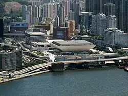


- Hong Kong Coliseum
- Hung Hom Municipal Building, which includes the Hung Hom Library, Hung Hom Municipal Building Sports Centre, and the Hung Hom Market with a cooked food centre
- Hung Hom Fire Station
- Two post offices and the International Mail Centre
- Hutchison Park, a small park located in a built up residential area once occupied by docklands and fill-in to create more land for residential use.
- Tai Wan Shan Park, Tai Wan Shan Swimming Pool
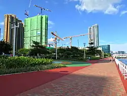
- Hung Hum Promenade
- Hong Kong Police Traffic Kowloon West Base
- Fortune Metropolis, a shopping mall in Hung Hom Bay
- The Whampoa, a shopping centre in Whampoa Garden
- Lux Theatre
- Hotels, including Kerry Hotel Hong Kong, Harbour Grand Kowloon and Harbour Plaza Metropolis
Religion

- Kwun Yum Temple. Built in 1873.[7] Grade II historic building
- Pak Tai Temple, located at No. 146 Ma Tau Wai Road. Built in 1876.[8] Grade III historic building
- Holy Carpenter Church (Anglican)
- St. Mary's Church (Catholic)
- True World Lutheran Church
Transport
MTR
Hung Hom is served by the Hung Hom station of the MTR. The station serves both the East Rail line and Tuen Ma line. This station also previously played host to the Intercity Through Train (and the KTT) serving neighboring Guangdong province and other major cities in mainland China.
As of October 2016, Ho Man Tin station and Whampoa station as part of an extension of the Kwun Tong line, are available for accessing the Hung Hom area.
Tunnel

The Cross-Harbour Tunnel, part of Route 1, was the first road tunnel in Hong Kong that was built under water. It opened on 2 August 1972, and it connects Hong Kong Island and Kowloon at Kellett Island and a reclaimed site at Hung Hom Bay, respectively.
Ferries

Ferries serving Hung Hom Ferry Pier:
- New World First Ferry: North Point Ferry Pier - Hung Hom Ferry Pier (HK$6.5)
- Fortune Ferry: Central Ferry Pier - Hung Hom Ferry Pier (HK$9)
Buses
There are three bus terminals in Hung Hom. Many buses serve the area.
- Solely-operated cross harbour route: 108
- Cross harbour routes operated with Citybus: 102, 102P, 103, 107, 107P, 117, 118, 118P, 170, 171, 182, N118, N170, N182
- Cross harbour routes operated with New World First Bus: 101, 101R, 101X, 102R, 104, 106, 106A, 106P, 109, 110, 111, 111P, 112, 113, 115, 115P, 116, 301, N121, N122;
- Non-cross harbour routes: 2E, 3B, 5, 5A, 5C, 5D, 6C, 6F, 7B, 8, 8A, 8P, 11, 11K, 11X, 12A, 12P, 13X, 14, 15, 15X, 21, 26, 28, 30X, 41, 45, 85S, 85X, 87D, 93K, 98D, 219X, 224X, 230X, 260X, 268B, 269B, 271S, 287D, 296D, 297, 297P, N41X, N216, N241, N271, N281;
- New World First Bus: 796X.
- Citybus: A20, A21, A22, A23, E21X, E23, E23A, R11, R22, N11, N23, NA20.
- Minibus routes: 2, 2A, 6, 6A, 6X, 8, 13.
See also
- List of places in Hong Kong
References
- ^ Philip Snow: The Fall of Hong Kong. 2003. ISBN 0300093527 page 159
- ^ "POA School Net 35" (PDF). Education Bureau. Retrieved 12 September 2022.
- ^ "紅磡官立小學 (下午) HUNG HOM GOVERNMENT PRIMARY PM SCHOOL". School.net.hk. Archived from the original on 31 January 1998. Retrieved 11 September 2022.
九龍紅磡機利士路68號 68 GILLIES AVENUE HUNG HOM KLN
- ^ a b "Contact Information". Kowloon Junior School. Archived from the original on 28 January 2013. Retrieved 11 September 2022.
HUNG HOM (Year 1 to 3) 68 Gillies Avenue South, Hung Hom, Kowloon, Hong Kong
- ^ "School List by District Kowloon City". Education Bureau. March 2015. Archived from the original on 29 June 2015. Retrieved 18 February 2022.
LYC'EE FRANCAIS INTL (FRENCH INTL SCH) NO. 68 GILLIES AVENUE KOWLOON
- ^ "Campuses - Hung Hom Archived 24 September 2015 at the Wayback Machine." Lycée Français International Victor Segalen. Retrieved on 25 January 2015. "68 Gillies Avenue South, Hung Hom, Hong Kong"
- ^ Chinese Temples Committee: Kwun Yum Temple, Hung Hom
- ^ Chinese Temples Committee: Pak Tai Temple, Hok Un Kok
External links
Urban areas of Hong Kong, Kowloon and New Territories | |||||||||||
|---|---|---|---|---|---|---|---|---|---|---|---|
| MHong Kong1,3,4,5,6,7,8,9a,10,11,12,14,15,16 |
|  | |||||||||
| MOld KowloonKL,1,2,3,4,5,6,7,8,9a,10,11,12,14,15,16 |
| ||||||||||
| MNew KowloonNKL,2,3,4,5,6,7,9a,10,11,12,14,15,16 |
| ||||||||||
| New Territories |
| ||||||||||
Official place names are summarized from "Geoinfo Map" of Government of Hong Kong Special Administrative Region, "Hong Kong Guide" of Lands Department, "Hong Kong Guide Book" of Universal Publications Ltd. and "Areas and Districts" of Rating and Valuation Department. M:Narrow meaning of urban areas KL: Kowloon Peninsula at the south of Boundary Street NKL: Former New Territories area at the north of Boundary Street and at the south of Lion Rock 1: Common definition (1) 2: Common definition (2) 3: Common definition (3) 4: Areas not adopting small house concessionary right of indigenous inhabitants 5: Jurisdiction area of former Urban Council 6: Definition of "Metropolitan Area" of Planning Department 7: Jurisdiction area of Urban Renewal Authority 8: Unique operating area of urban taxis 9: "Urban" (9a) and "Extended Urban" (9b) areas defined by Hong Kong Housing Authority 10: Definition of Urban rates 11: Hospital cluster belongs to Hong Kong or Kowloon 12: Police region belongs to Hong Kong or Kowloon 13: Regions having 999-year land lease 14: Geographical Constituency in Hong Kong Legislative Council belongs to Hong Kong or Kowloon 15: Regional Education Office belongs to Hong Kong or Kowloon 16: Primary One Admission School Net belongs to Hong Kong or Kowloon | |||||||||||