Wong Chuk Hang
Wong Chuk Hang
黃竹坑 | |
|---|---|
Suburb | |
| Wong Chuk Hang | |
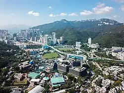 A view of residential Wong Chuk Hang from the Ocean Park cable car system | |
| Country | |
| District | Southern District |
| Seat | Wong Chuk Hang |
| Government | |
| • Body | District Council |
| • District Councillor | Tsui Yuen-wa (Democratic Party) |
| Wong Chuk Hang | |||||||||||||||||||
|---|---|---|---|---|---|---|---|---|---|---|---|---|---|---|---|---|---|---|---|
| Traditional Chinese | 黃竹坑 | ||||||||||||||||||
| Simplified Chinese | 黄竹坑 | ||||||||||||||||||
| Cantonese Yale | Wòhngjūkhāang | ||||||||||||||||||
| Literal meaning | "Yellow Bamboo Pit" | ||||||||||||||||||
| |||||||||||||||||||
Wong Chuk Hang (Cantonese pronunciation: [wɔ̏ːŋ tsók̚ háːŋ]) is a neighbourhood in the Southern District of Hong Kong Island, in Hong Kong.
History
Neolithic artifacts have been unearthed in a region called Chung Hom Wan, which is not far from Wong Chuk Hang.[1] In 1550 the Hong Kong Village (香港村) was established in Wong Chuk Hang; it still exists, much diminished in size, as Wong Chuk Hang Kau Wai. A satellite village, Wong Chuk Hang San Wai, was established in the 1860s and 1870s.[2] The name Staunton (along with valley and creek) is likely linked to Sir George Staunton, 2nd Baronet.
Features
Features of Wong Chuk Hang include:
- Grantham Hospital
- Holy Spirit Seminary
- Hong Kong Police Training School
- Ocean Park
- Wong Chuk Hang Estate
Economy
The head office of the clothing Lane Crawford is in One Island South, Wong Chuk Hang.[3]
Climate
| Climate data for Wong Chuk Hang (1990–2016) | |||||||||||||
|---|---|---|---|---|---|---|---|---|---|---|---|---|---|
| Month | Jan | Feb | Mar | Apr | May | Jun | Jul | Aug | Sep | Oct | Nov | Dec | Year |
| Record high °C (°F) | 28.0 (82.4) |
28.5 (83.3) |
30.3 (86.5) |
30.9 (87.6) |
32.5 (90.5) |
35.3 (95.5) |
36.2 (97.2) |
36.0 (96.8) |
36.0 (96.8) |
33.4 (92.1) |
31.7 (89.1) |
29.4 (84.9) |
36.2 (97.2) |
| Mean daily maximum °C (°F) | 19.5 (67.1) |
20.2 (68.4) |
22.3 (72.1) |
25.3 (77.5) |
28.3 (82.9) |
29.8 (85.6) |
30.7 (87.3) |
30.8 (87.4) |
30.3 (86.5) |
28.2 (82.8) |
25.2 (77.4) |
21.4 (70.5) |
26.0 (78.8) |
| Daily mean °C (°F) | 16.4 (61.5) |
17.3 (63.1) |
19.6 (67.3) |
22.9 (73.2) |
25.9 (78.6) |
27.7 (81.9) |
28.3 (82.9) |
28.2 (82.8) |
27.5 (81.5) |
25.3 (77.5) |
22.0 (71.6) |
18.1 (64.6) |
23.3 (73.9) |
| Mean daily minimum °C (°F) | 13.8 (56.8) |
14.9 (58.8) |
17.3 (63.1) |
20.8 (69.4) |
23.9 (75.0) |
25.9 (78.6) |
26.2 (79.2) |
26.0 (78.8) |
25.3 (77.5) |
23.0 (73.4) |
19.5 (67.1) |
15.4 (59.7) |
21.0 (69.8) |
| Record low °C (°F) | 3.4 (38.1) |
7.0 (44.6) |
9.0 (48.2) |
10.9 (51.6) |
16.1 (61.0) |
20.8 (69.4) |
22.6 (72.7) |
22.5 (72.5) |
18.7 (65.7) |
16.3 (61.3) |
9.6 (49.3) |
4.7 (40.5) |
3.4 (38.1) |
| Average precipitation mm (inches) | 33.7 (1.33) |
25.5 (1.00) |
75.8 (2.98) |
162.9 (6.41) |
300.5 (11.83) |
472.9 (18.62) |
359.3 (14.15) |
396.3 (15.60) |
327.9 (12.91) |
85.9 (3.38) |
41.4 (1.63) |
29.6 (1.17) |
2,311.7 (91.01) |
| Average rainy days (≥ 0.5 mm) | 3.8 | 5.5 | 7.1 | 9.7 | 13.2 | 18.0 | 16.4 | 14.5 | 12.7 | 6.8 | 4.4 | 4.8 | 116.9 |
| Average relative humidity (%) | 71 | 76 | 79 | 83 | 84 | 85 | 83 | 83 | 78 | 71 | 70 | 67 | 77 |
| Source: Hong Kong Observatory[4] | |||||||||||||
Transport
- Road
Aberdeen Tunnel is a two-tube tunnel linking Wong Chuk Hang and Happy Valley.
- Rail
Ocean Park station and Wong Chuk Hang station, stations of the MTR South Island line.
Education
Wong Chuk Hang is in Primary One Admission (POA) School Net 18. Within the school net are multiple aided schools (operated independently but funded with government money) and Hong Kong Southern District Government Primary School.[5]
See also
- Wong Chuk Hang (constituency)
- Prehistoric Hong Kong
References
- ^ Reference: Hong Kong Archaeological Society website
- ^ Antiquities and Monuments Office. Old House, No. 10, Wong Chuk Hang San Wai – Now Opens
- ^ "Data Analytics Policy". Lane Crawford. Retrieved 23 April 2021.
Lane Crawford, 30F, One Island South, 2 Heung Yip Road Wong Chuk Hang, Hong Kong SAR.
- ^ "Monthly Means of Meteorological Elements for Wong Chuk Hang, 1990-2016". Hong Kong Observatory. Retrieved 8 February 2017.
- ^ "POA School Net 18" (PDF). Education Bureau. Retrieved 12 September 2022.
Urban areas of Hong Kong, Kowloon and New Territories | |||||||||||
|---|---|---|---|---|---|---|---|---|---|---|---|
| MHong Kong1,3,4,5,6,7,8,9a,10,11,12,14,15,16 |
|  | |||||||||
| MOld KowloonKL,1,2,3,4,5,6,7,8,9a,10,11,12,14,15,16 |
| ||||||||||
| MNew KowloonNKL,2,3,4,5,6,7,9a,10,11,12,14,15,16 |
| ||||||||||
| New Territories |
| ||||||||||
Official place names are summarized from "Geoinfo Map" of Government of Hong Kong Special Administrative Region, "Hong Kong Guide" of Lands Department, "Hong Kong Guide Book" of Universal Publications Ltd. and "Areas and Districts" of Rating and Valuation Department. M:Narrow meaning of urban areas KL: Kowloon Peninsula at the south of Boundary Street NKL: Former New Territories area at the north of Boundary Street and at the south of Lion Rock 1: Common definition (1) 2: Common definition (2) 3: Common definition (3) 4: Areas not adopting small house concessionary right of indigenous inhabitants 5: Jurisdiction area of former Urban Council 6: Definition of "Metropolitan Area" of Planning Department 7: Jurisdiction area of Urban Renewal Authority 8: Unique operating area of urban taxis 9: "Urban" (9a) and "Extended Urban" (9b) areas defined by Hong Kong Housing Authority 10: Definition of Urban rates 11: Hospital cluster belongs to Hong Kong or Kowloon 12: Police region belongs to Hong Kong or Kowloon 13: Regions having 999-year land lease 14: Geographical Constituency in Hong Kong Legislative Council belongs to Hong Kong or Kowloon 15: Regional Education Office belongs to Hong Kong or Kowloon 16: Primary One Admission School Net belongs to Hong Kong or Kowloon | |||||||||||