List of mountain peaks of Idaho
This article comprises three sortable tables of major mountain peaks[1] of the U.S. State of Idaho.
The summit of a mountain or hill may be measured in three principal ways:
- The topographic elevation of a summit measures the height of the summit above a geodetic sea level.[2][3] The first table below ranks the 40 highest major summits of Idaho by elevation.
- The topographic prominence of a summit is a measure of how high the summit rises above its surroundings.[4][3] The second table below ranks the 40 most prominent summits of Idaho.
- The topographic isolation (or radius of dominance) of a summit measures how far the summit lies from its nearest point of equal elevation.[5] The third table below ranks the 40 most isolated major summits of Idaho.
Highest major summits
Of the highest major summits of Idaho, ten peaks exceed 3500 meters (11,483 feet) elevation and 34 peaks exceed 3000 meters (9843 feet) elevation.
| Rank | Mountain peak | Mountain range | Elevation | Prominence | Isolation | Location |
|---|---|---|---|---|---|---|
| 1 | Borah Peak[6][7][8][9][a] | Lost River Range | 12,668 ft 3861.2 m |
6,002 ft 1829 m |
150.8 mi 243 km |
44°08′15″N 113°46′52″W / 44.1374°N 113.7811°W |
| 2 | Leatherman Peak[10][11][12][b] | Lost River Range | 12,233 ft 3729 m |
1,688 ft 515 m |
4.51 mi 7.26 km |
44°04′55″N 113°43′59″W / 44.0820°N 113.7330°W |
| 3 | Diamond Peak[13][14][15][16][c] | Lemhi Range | 12,202 ft 3719.3 m |
5,387 ft 1642 m |
31.8 mi 51.2 km |
44°08′29″N 113°04′58″W / 44.1414°N 113.0827°W |
| 4 | Hyndman Peak[17][18][19][20][d] | Pioneer Mountains | 12,012 ft 3661.4 m |
4,829 ft 1472 m |
30.1 mi 48.5 km |
43°44′58″N 114°07′52″W / 43.7494°N 114.1311°W |
| 5 | USGS Peak[21][22] | Lost River Range | 11,988 ft 3653.8 m |
1,802 ft 549 m |
4.14 mi 6.66 km |
44°00′48″N 113°34′54″W / 44.0133°N 113.5818°W |
| 6 | Castle Peak[23][24][25][e] | White Cloud Mountains | 11,812 ft 3600.4 m |
4,035 ft 1230 m |
27.3 mi 44 km |
44°02′25″N 114°35′19″W / 44.0402°N 114.5887°W |
| 7 | Ryan Peak[26][27][28][29][f] | Boulder Mountains | 11,720 ft 3572.2 m |
3,214 ft 980 m |
12.97 mi 20.9 km |
43°54′09″N 114°24′35″W / 43.9024°N 114.4096°W |
| 8 | Bell Mountain[30][31][32][33] | Lemhi Range | 11,617 ft 3540.9 m |
1,752 ft 534 m |
8.56 mi 13.77 km |
44°14′10″N 113°11′38″W / 44.2362°N 113.1939°W |
| 9 | Glassford Peak[34][35][36][g] | Boulder Mountains | 11,607 ft 3538 m |
1,782 ft 543 m |
3.64 mi 5.85 km |
43°54′44″N 114°28′52″W / 43.9123°N 114.4811°W |
| 10 | Smiley Mountain[37][38][39][40] | Pioneer Mountains | 11,511 ft 3508.6 m |
2,648 ft 807 m |
11.28 mi 18.15 km |
43°41′58″N 113°48′36″W / 43.6994°N 113.8100°W |
| 11 | Scott Peak[41][42][43][44][h] | Beaverhead Mountains | 11,398 ft 3474.2 m |
4,243 ft 1293 m |
19.56 mi 31.5 km |
44°21′13″N 112°49′16″W / 44.3536°N 112.8211°W |
| 12 | Big Creek Peak[45][46][47][48] | Lemhi Range | 11,355 ft 3461.1 m |
2,517 ft 767 m |
22.4 mi 36.1 km |
44°28′18″N 113°32′35″W / 44.4717°N 113.5430°W |
| 13 | Shelly Mountain[49][50][51][52][i] | White Knob Mountains | 11,283 ft 3439.2 m |
2,344 ft 714 m |
9.71 mi 15.63 km |
43°49′35″N 113°43′35″W / 43.8265°N 113.7263°W |
| 14 | Dickey Peak[53][54][55][56] | Lost River Range | 11,146 ft 3397.3 m |
2,823 ft 860 m |
4.49 mi 7.22 km |
44°13′45″N 113°53′01″W / 44.2293°N 113.8835°W |
| 15 | South Lost River Range high point[57][58][j] | Lost River Range | 11,086 ft 3379 m |
3,444 ft 1050 m |
9.33 mi 15.02 km |
43°55′45″N 113°20′07″W / 43.9291°N 113.3353°W |
| 16 | Lem Peak[59][60][61] | Lemhi Range | 10,990 ft 3349.8 m |
2,485 ft 757 m |
26.5 mi 42.7 km |
44°46′51″N 113°51′59″W / 44.7807°N 113.8664°W |
| 17 | Sheep Mountain[62][63][64][65] | Boulder Mountains | 10,913 ft 3326.4 m |
2,288 ft 697 m |
8.72 mi 14.04 km |
44°03′53″N 114°21′36″W / 44.0646°N 114.3601°W |
| 18 | Saddle Mountain[66][67][68][69] | Lemhi Range | 10,813 ft 3295.8 m |
2,385 ft 727 m |
11.18 mi 18 km |
43°56′15″N 112°57′16″W / 43.9374°N 112.9544°W |
| 19 | Thompson Peak[70][71][72][73][k] | Sawtooth Range | 10,756 ft 3278.4 m |
2,451 ft 747 m |
17.77 mi 28.6 km |
44°08′29″N 115°00′36″W / 44.1415°N 115.0100°W |
| 20 | White Mountain West[74][l][m] | Salmon River Mountains | 10,447 ft 3184 m |
3,772 ft 1150 m |
29.6 mi 47.6 km |
44°34′30″N 114°29′45″W / 44.5749°N 114.4959°W |
| 21 | Bromaghin Peak South[75][76][77][n][o] | Smoky Mountains | 10,446 ft 3184 m |
1,781 ft 543 m |
6.86 mi 11.04 km |
43°49′19″N 114°42′47″W / 43.8220°N 114.7131°W |
| 22 | Cache Peak[78][79][80][81][p] | Albion Range | 10,343 ft 3152.5 m |
4,479 ft 1365 m |
81.8 mi 131.6 km |
42°11′08″N 113°39′40″W / 42.1856°N 113.6611°W |
| 23 | The General[82][83][84] | Salmon River Mountains | 10,333 ft 3149.5 m |
1,909 ft 582 m |
16.42 mi 26.4 km |
44°29′01″N 114°48′11″W / 44.4836°N 114.8031°W |
| 24 | Bald Mountain[85][86][87][88] | Salmon River Mountains | 10,318 ft 3144.9 m |
2,013 ft 614 m |
16.18 mi 26 km |
44°22′02″N 114°20′39″W / 44.3672°N 114.3441°W |
| 25 | Vienna Benchmark[89][90][91][q] | Smoky Mountains | 10,232 ft 3118.8 m |
1,764 ft 538 m |
6.7 mi 10.78 km |
43°51′02″N 114°51′12″W / 43.8506°N 114.8534°W |
| 26 | Mount Jefferson[92][93][94][95][r][s] | Bitterroot Range | 10,216 ft 3113.7 m |
3,383 ft 1031 m |
11.2 mi 18.02 km |
44°33′43″N 111°30′18″W / 44.5620°N 111.5049°W |
| 27 | Mount Regan[96][97][98][t] | Sawtooth Range | 10,195 ft 3108 m |
1,730 ft 527 m |
1.9 mi 3.06 km |
44°09′35″N 115°03′42″W / 44.1598°N 115.0616°W |
| 28 | Smoky Dome[99][100][101][102][u] | Soldier Mountains | 10,096 ft 3077.4 m |
3,275 ft 998 m |
16.98 mi 27.3 km |
43°29′36″N 114°56′10″W / 43.4933°N 114.9362°W |
| 29 | Mount McGuire[103][104][105][v] | Salmon River Mountains | 10,087 ft 3074.6 m |
3,542 ft 1080 m |
39.7 mi 64 km |
45°10′27″N 114°36′08″W / 45.1742°N 114.6021°W |
| 30 | Meade Peak[106][107][108][109][w] | Preuss Range | 9,963 ft 3036.8 m |
2,497 ft 761 m |
23.5 mi 37.7 km |
42°29′43″N 111°14′56″W / 42.4954°N 111.2490°W |
| 31 | Goat Mountain[110][111][112][113] | Beaverhead Mountains | 9,948 ft 3032.2 m |
2,283 ft 696 m |
16.44 mi 26.5 km |
44°49′24″N 113°26′20″W / 44.8234°N 113.4388°W |
| 32 | Pinyon Peak[114][115][116] | Salmon River Mountains | 9,946 ft 3031.5 m |
2,002 ft 610 m |
8.21 mi 13.21 km |
44°34′11″N 114°55′00″W / 44.5697°N 114.9168°W |
| 33 | Sleeping Deer Mountain[117][118][119][120] | Salmon River Mountains | 9,887 ft 3013.6 m |
1,861 ft 567 m |
15.75 mi 25.3 km |
44°46′02″N 114°41′29″W / 44.7672°N 114.6913°W |
| 34 | Taylor Mountain[121][122][123][124][x] | Bitterroot Range | 9,860 ft 3005.2 m |
1,880 ft 573 m |
8.79 mi 14.15 km |
44°33′42″N 111°40′59″W / 44.5616°N 111.6830°W |
| 35 | She Devil[125][126][127][y][z] | Seven Devils Mountains | 9,424 ft 2873 m |
5,240 ft 1597 m |
31.5 mi 50.6 km |
45°19′26″N 116°32′26″W / 45.3240°N 116.5406°W |
| 36 | Black Pine Mountains high point[128][129][aa] | Black Pine Mountains | 9,389 ft 2861.7 m |
4,095 ft 1248 m |
20.1 mi 32.3 km |
42°08′20″N 113°07′33″W / 42.1389°N 113.1259°W |
| 37 | North Loon Mountain[130][131][132][ab][ac] | Salmon River Mountains | 9,326 ft 2843 m |
2,974 ft 906 m |
31.7 mi 51.1 km |
45°06′45″N 115°52′22″W / 45.1125°N 115.8728°W |
| 38 | Oxford Peak[133][134][135][136][ad] | Bannock Range | 9,285 ft 2830.2 m |
4,012 ft 1223 m |
26.6 mi 42.8 km |
42°16′11″N 112°05′52″W / 42.2696°N 112.0979°W |
| 39 | Bonneville Peak[137][138][139][ae][af] | Portneuf Range | 9,275 ft 2827 m |
3,401 ft 1037 m |
34.1 mi 54.9 km |
42°45′48″N 112°08′28″W / 42.7633°N 112.1411°W |
| 40 | Sedgwick Peak[140][141][142][143][ag] | Portneuf Range | 9,176 ft 2796.8 m |
3,642 ft 1110 m |
19.19 mi 30.9 km |
42°30′57″N 111°55′24″W / 42.5157°N 111.9234°W |
Most prominent summits
Of the most prominent summits of Idaho, three peaks are ultra-prominent summits with more than 1500 meters (4921 feet) of topographic prominence and 20 peaks exceed 1000 meters (3281 feet) of topographic prominence.
| Rank | Mountain peak | Mountain range | Elevation | Prominence | Isolation | Location |
|---|---|---|---|---|---|---|
| 1 | Borah Peak[6][7][8][9][a] | Lost River Range | 12,668 ft 3861.2 m |
6,002 ft 1829 m |
150.8 mi 243 km |
44°08′15″N 113°46′52″W / 44.1374°N 113.7811°W |
| 2 | Diamond Peak[13][14][15][16][c] | Lemhi Range | 12,202 ft 3719.3 m |
5,387 ft 1642 m |
31.8 mi 51.2 km |
44°08′29″N 113°04′58″W / 44.1414°N 113.0827°W |
| 3 | She Devil[125][126][127][y][z] | Seven Devils Mountains | 9,424 ft 2873 m |
5,240 ft 1597 m |
31.5 mi 50.6 km |
45°19′26″N 116°32′26″W / 45.3240°N 116.5406°W |
| 4 | Hyndman Peak[17][18][19][20][d] | Pioneer Mountains | 12,012 ft 3661.4 m |
4,829 ft 1472 m |
30.1 mi 48.5 km |
43°44′58″N 114°07′52″W / 43.7494°N 114.1311°W |
| 5 | Scotchman Peak[144][145][146][147] | Cabinet Mountains | 7,017 ft 2138.7 m |
4,669 ft 1423 m |
17.99 mi 29 km |
48°11′21″N 116°04′53″W / 48.1891°N 116.0813°W |
| 6 | Cache Peak[78][79][80][81][p] | Albion Range | 10,343 ft 3152.5 m |
4,479 ft 1365 m |
81.8 mi 131.6 km |
42°11′08″N 113°39′40″W / 42.1856°N 113.6611°W |
| 7 | Scott Peak[41][42][43][44][h] | Beaverhead Mountains | 11,398 ft 3474.2 m |
4,243 ft 1293 m |
19.56 mi 31.5 km |
44°21′13″N 112°49′16″W / 44.3536°N 112.8211°W |
| 8 | Black Pine Mountains high point[128][129][aa] | Black Pine Mountains | 9,389 ft 2861.7 m |
4,095 ft 1248 m |
20.1 mi 32.3 km |
42°08′20″N 113°07′33″W / 42.1389°N 113.1259°W |
| 9 | Castle Peak[23][24][25][e] | White Cloud Mountains | 11,812 ft 3600.4 m |
4,035 ft 1230 m |
27.3 mi 44 km |
44°02′25″N 114°35′19″W / 44.0402°N 114.5887°W |
| 10 | Oxford Peak[133][134][135][136][ad] | Bannock Range | 9,285 ft 2830.2 m |
4,012 ft 1223 m |
26.6 mi 42.8 km |
42°16′11″N 112°05′52″W / 42.2696°N 112.0979°W |
| 11 | White Mountain West[74][l][m] | Salmon River Mountains | 10,447 ft 3184 m |
3,772 ft 1150 m |
29.6 mi 47.6 km |
44°34′30″N 114°29′45″W / 44.5749°N 114.4959°W |
| 12 | Sedgwick Peak[140][141][142][143][ag] | Portneuf Range | 9,176 ft 2796.8 m |
3,642 ft 1110 m |
19.19 mi 30.9 km |
42°30′57″N 111°55′24″W / 42.5157°N 111.9234°W |
| 13 | Mount McGuire[103][104][105][v] | Salmon River Mountains | 10,087 ft 3074.6 m |
3,542 ft 1080 m |
39.7 mi 64 km |
45°10′27″N 114°36′08″W / 45.1742°N 114.6021°W |
| 14 | Elkhorn Peak[148][149][150][151] | Bannock Range | 9,095 ft 2772.3 m |
3,515 ft 1071 m |
12.63 mi 20.3 km |
42°20′02″N 112°19′43″W / 42.3340°N 112.3285°W |
| 15 | Sturgill Peak[152][153][154][ah] | Hitt Mountains | 7,593 ft 2314.3 m |
3,449 ft 1051 m |
13.06 mi 21 km |
44°37′12″N 116°56′36″W / 44.6200°N 116.9433°W |
| 16 | South Lost River Range high point[57][58][j] | Lost River Range | 11,086 ft 3379 m |
3,444 ft 1050 m |
9.33 mi 15.02 km |
43°55′45″N 113°20′07″W / 43.9291°N 113.3353°W |
| 17 | Buffalo Hump[155][156][157][158] | Clearwater Mountains | 8,942 ft 2725.6 m |
3,438 ft 1048 m |
33.1 mi 53.3 km |
45°37′14″N 115°41′57″W / 45.6205°N 115.6993°W |
| 18 | Bonneville Peak[137][138][139][ae][af] | Portneuf Range | 9,275 ft 2827 m |
3,401 ft 1037 m |
34.1 mi 54.9 km |
42°45′48″N 112°08′28″W / 42.7633°N 112.1411°W |
| 19 | Mount Jefferson[92][93][94][95][r][s] | Bitterroot Range | 10,216 ft 3113.7 m |
3,383 ft 1031 m |
11.2 mi 18.02 km |
44°33′43″N 111°30′18″W / 44.5620°N 111.5049°W |
| 20 | South Selkirk Crest[159][ai] | Selkirk Mountains | 7,719 ft 2353 m |
3,375 ft 1029 m |
29.5 mi 47.5 km |
48°50′44″N 116°33′16″W / 48.8455°N 116.5544°W |
| 21 | Smoky Dome[99][100][101][102][u] | Soldier Mountains | 10,096 ft 3077.4 m |
3,275 ft 998 m |
16.98 mi 27.3 km |
43°29′36″N 114°56′10″W / 43.4933°N 114.9362°W |
| 22 | Queen Mountain[160][161][162][163] | Purcell Mountains | 6,116 ft 1864.2 m |
3,252 ft 991 m |
8.62 mi 13.87 km |
48°52′42″N 116°12′54″W / 48.8782°N 116.2150°W |
| 23 | Deep Creek Peak[164][165][166][167][aj] | Deep Creek Mountains | 8,752 ft 2667.7 m |
3,248 ft 990 m |
19.26 mi 31 km |
42°28′17″N 112°39′22″W / 42.4713°N 112.6560°W |
| 24 | Ryan Peak[26][27][28][29][f] | Boulder Mountains | 11,720 ft 3572.2 m |
3,214 ft 980 m |
12.97 mi 20.9 km |
43°54′09″N 114°24′35″W / 43.9024°N 114.4096°W |
| 25 | Cinnabar Mountain[168][169][170][ak] | Owyhee Mountains | 8,409 ft 2563.2 m |
3,133 ft 955 m |
71.5 mi 115.1 km |
42°58′50″N 116°39′27″W / 42.9805°N 116.6575°W |
| 26 | North Loon Mountain[130][131][132][ab][ac] | Salmon River Mountains | 9,326 ft 2843 m |
2,974 ft 906 m |
31.7 mi 51.1 km |
45°06′45″N 115°52′22″W / 45.1125°N 115.8728°W |
| 27 | Dickey Peak[53][54][55][56] | Lost River Range | 11,146 ft 3397.3 m |
2,823 ft 860 m |
4.49 mi 7.22 km |
44°13′45″N 113°53′01″W / 44.2293°N 113.8835°W |
| 28 | Smiley Mountain[37][38][39][40] | Pioneer Mountains | 11,511 ft 3508.6 m |
2,648 ft 807 m |
11.28 mi 18.15 km |
43°41′58″N 113°48′36″W / 43.6994°N 113.8100°W |
| 29 | Big Creek Peak[45][46][47][48] | Lemhi Range | 11,355 ft 3461.1 m |
2,517 ft 767 m |
22.4 mi 36.1 km |
44°28′18″N 113°32′35″W / 44.4717°N 113.5430°W |
| 30 | Meade Peak[106][107][108][109][w] | Preuss Range | 9,963 ft 3036.8 m |
2,497 ft 761 m |
23.5 mi 37.7 km |
42°29′43″N 111°14′56″W / 42.4954°N 111.2490°W |
| 31 | Lem Peak[59][60][61] | Lemhi Range | 10,990 ft 3349.8 m |
2,485 ft 757 m |
26.5 mi 42.7 km |
44°46′51″N 113°51′59″W / 44.7807°N 113.8664°W |
| 32 | Thompson Peak[70][71][72][73][k] | Sawtooth Range | 10,756 ft 3278.4 m |
2,451 ft 747 m |
17.77 mi 28.6 km |
44°08′29″N 115°00′36″W / 44.1415°N 115.0100°W |
| 33 | Saddle Mountain[66][67][68][69] | Lemhi Range | 10,813 ft 3295.8 m |
2,385 ft 727 m |
11.18 mi 18 km |
43°56′15″N 112°57′16″W / 43.9374°N 112.9544°W |
| 34 | Shelly Mountain[49][50][51][52][i] | White Knob Mountains | 11,283 ft 3439.2 m |
2,344 ft 714 m |
9.71 mi 15.63 km |
43°49′35″N 113°43′35″W / 43.8265°N 113.7263°W |
| 35 | Sheep Mountain[62][63][64][65] | Boulder Mountains | 10,913 ft 3326.4 m |
2,288 ft 697 m |
8.72 mi 14.04 km |
44°03′53″N 114°21′36″W / 44.0646°N 114.3601°W |
| 36 | Goat Mountain[110][111][112][113] | Beaverhead Mountains | 9,948 ft 3032.2 m |
2,283 ft 696 m |
16.44 mi 26.5 km |
44°49′24″N 113°26′20″W / 44.8234°N 113.4388°W |
| 37 | Bald Mountain[85][86][87][88] | Salmon River Mountains | 10,318 ft 3144.9 m |
2,013 ft 614 m |
16.18 mi 26 km |
44°22′02″N 114°20′39″W / 44.3672°N 114.3441°W |
| 38 | Pinyon Peak[114][115][116] | Salmon River Mountains | 9,946 ft 3031.5 m |
2,002 ft 610 m |
8.21 mi 13.21 km |
44°34′11″N 114°55′00″W / 44.5697°N 114.9168°W |
| 39 | The General[82][83][84] | Salmon River Mountains | 10,333 ft 3149.5 m |
1,909 ft 582 m |
16.42 mi 26.4 km |
44°29′01″N 114°48′11″W / 44.4836°N 114.8031°W |
| 40 | Taylor Mountain[121][122][123][124][x] | Bitterroot Range | 9,860 ft 3005.2 m |
1,880 ft 573 m |
8.79 mi 14.15 km |
44°33′42″N 111°40′59″W / 44.5616°N 111.6830°W |
Most isolated major summits
Of the most isolated major summits of Idaho, Borah Peak exceeds 200 kilometers (124.3 miles) of topographic isolation and three peaks exceed 100 kilometers (62.14 miles) of topographic isolation.
| Rank | Mountain peak | Mountain range | Elevation | Prominence | Isolation | Location |
|---|---|---|---|---|---|---|
| 1 | Borah Peak[6][7][8][9][a] | Lost River Range | 12,668 ft 3861.2 m |
6,002 ft 1829 m |
150.8 mi 243 km |
44°08′15″N 113°46′52″W / 44.1374°N 113.7811°W |
| 2 | Cache Peak[78][79][80][81][p] | Albion Range | 10,343 ft 3152.5 m |
4,479 ft 1365 m |
81.8 mi 131.6 km |
42°11′08″N 113°39′40″W / 42.1856°N 113.6611°W |
| 3 | Cinnabar Mountain[168][169][170][ak] | Owyhee Mountains | 8,409 ft 2563.2 m |
3,133 ft 955 m |
71.5 mi 115.1 km |
42°58′50″N 116°39′27″W / 42.9805°N 116.6575°W |
| 4 | Mount McGuire[103][104][105][v] | Salmon River Mountains | 10,087 ft 3074.6 m |
3,542 ft 1080 m |
39.7 mi 64 km |
45°10′27″N 114°36′08″W / 45.1742°N 114.6021°W |
| 5 | Bonneville Peak[137][138][139][ae][af] | Portneuf Range | 9,275 ft 2827 m |
3,401 ft 1037 m |
34.1 mi 54.9 km |
42°45′48″N 112°08′28″W / 42.7633°N 112.1411°W |
| 6 | Buffalo Hump[155][156][157][158] | Clearwater Mountains | 8,942 ft 2725.6 m |
3,438 ft 1048 m |
33.1 mi 53.3 km |
45°37′14″N 115°41′57″W / 45.6205°N 115.6993°W |
| 7 | Diamond Peak[13][14][15][16][c] | Lemhi Range | 12,202 ft 3719.3 m |
5,387 ft 1642 m |
31.8 mi 51.2 km |
44°08′29″N 113°04′58″W / 44.1414°N 113.0827°W |
| 8 | North Loon Mountain[130][131][132][ab][ac] | Salmon River Mountains | 9,326 ft 2843 m |
2,974 ft 906 m |
31.7 mi 51.1 km |
45°06′45″N 115°52′22″W / 45.1125°N 115.8728°W |
| 9 | She Devil[125][126][127][y][z] | Seven Devils Mountains | 9,424 ft 2873 m |
5,240 ft 1597 m |
31.5 mi 50.6 km |
45°19′26″N 116°32′26″W / 45.3240°N 116.5406°W |
| 10 | Hyndman Peak[17][18][19][20][d] | Pioneer Mountains | 12,012 ft 3661.4 m |
4,829 ft 1472 m |
30.1 mi 48.5 km |
43°44′58″N 114°07′52″W / 43.7494°N 114.1311°W |
| 11 | White Mountain West[74][l][m] | Salmon River Mountains | 10,447 ft 3184 m |
3,772 ft 1150 m |
29.6 mi 47.6 km |
44°34′30″N 114°29′45″W / 44.5749°N 114.4959°W |
| 12 | South Selkirk Crest[159][ai] | Selkirk Mountains | 7,719 ft 2353 m |
3,375 ft 1029 m |
29.5 mi 47.5 km |
48°50′44″N 116°33′16″W / 48.8455°N 116.5544°W |
| 13 | Castle Peak[23][24][25][e] | White Cloud Mountains | 11,812 ft 3600.4 m |
4,035 ft 1230 m |
27.3 mi 44 km |
44°02′25″N 114°35′19″W / 44.0402°N 114.5887°W |
| 14 | Oxford Peak[133][134][135][136][ad] | Bannock Range | 9,285 ft 2830.2 m |
4,012 ft 1223 m |
26.6 mi 42.8 km |
42°16′11″N 112°05′52″W / 42.2696°N 112.0979°W |
| 15 | Lem Peak[59][60][61] | Lemhi Range | 10,990 ft 3349.8 m |
2,485 ft 757 m |
26.5 mi 42.7 km |
44°46′51″N 113°51′59″W / 44.7807°N 113.8664°W |
| 16 | Meade Peak[106][107][108][109][w] | Preuss Range | 9,963 ft 3036.8 m |
2,497 ft 761 m |
23.5 mi 37.7 km |
42°29′43″N 111°14′56″W / 42.4954°N 111.2490°W |
| 17 | Big Creek Peak[45][46][47][48] | Lemhi Range | 11,355 ft 3461.1 m |
2,517 ft 767 m |
22.4 mi 36.1 km |
44°28′18″N 113°32′35″W / 44.4717°N 113.5430°W |
| 18 | Black Pine Mountains high point[128][129][aa] | Black Pine Mountains | 9,389 ft 2861.7 m |
4,095 ft 1248 m |
20.1 mi 32.3 km |
42°08′20″N 113°07′33″W / 42.1389°N 113.1259°W |
| 19 | Scott Peak[41][42][43][44][h] | Beaverhead Mountains | 11,398 ft 3474.2 m |
4,243 ft 1293 m |
19.56 mi 31.5 km |
44°21′13″N 112°49′16″W / 44.3536°N 112.8211°W |
| 20 | Deep Creek Peak[164][165][166][167][aj] | Deep Creek Mountains | 8,752 ft 2667.7 m |
3,248 ft 990 m |
19.26 mi 31 km |
42°28′17″N 112°39′22″W / 42.4713°N 112.6560°W |
| 21 | Sedgwick Peak[140][141][142][143][ag] | Portneuf Range | 9,176 ft 2796.8 m |
3,642 ft 1110 m |
19.19 mi 30.9 km |
42°30′57″N 111°55′24″W / 42.5157°N 111.9234°W |
| 22 | Scotchman Peak[144][145][146][147] | Cabinet Mountains | 7,017 ft 2138.7 m |
4,669 ft 1423 m |
17.99 mi 29 km |
48°11′21″N 116°04′53″W / 48.1891°N 116.0813°W |
| 23 | Thompson Peak[70][71][72][73][k] | Sawtooth Range | 10,756 ft 3278.4 m |
2,451 ft 747 m |
17.77 mi 28.6 km |
44°08′29″N 115°00′36″W / 44.1415°N 115.0100°W |
| 24 | Smoky Dome[99][100][101][102][u] | Soldier Mountains | 10,096 ft 3077.4 m |
3,275 ft 998 m |
16.98 mi 27.3 km |
43°29′36″N 114°56′10″W / 43.4933°N 114.9362°W |
| 25 | Goat Mountain[110][111][112][113] | Beaverhead Mountains | 9,948 ft 3032.2 m |
2,283 ft 696 m |
16.44 mi 26.5 km |
44°49′24″N 113°26′20″W / 44.8234°N 113.4388°W |
| 26 | The General[82][83][84] | Salmon River Mountains | 10,333 ft 3149.5 m |
1,909 ft 582 m |
16.42 mi 26.4 km |
44°29′01″N 114°48′11″W / 44.4836°N 114.8031°W |
| 27 | Bald Mountain[85][86][87][88] | Salmon River Mountains | 10,318 ft 3144.9 m |
2,013 ft 614 m |
16.18 mi 26 km |
44°22′02″N 114°20′39″W / 44.3672°N 114.3441°W |
| 28 | Sleeping Deer Mountain[117][118][119][120] | Salmon River Mountains | 9,887 ft 3013.6 m |
1,861 ft 567 m |
15.75 mi 25.3 km |
44°46′02″N 114°41′29″W / 44.7672°N 114.6913°W |
| 29 | Sturgill Peak[152][153][154][ah] | Hitt Mountains | 7,593 ft 2314.3 m |
3,449 ft 1051 m |
13.06 mi 21 km |
44°37′12″N 116°56′36″W / 44.6200°N 116.9433°W |
| 30 | Ryan Peak[26][27][28][29][f] | Boulder Mountains | 11,720 ft 3572.2 m |
3,214 ft 980 m |
12.97 mi 20.9 km |
43°54′09″N 114°24′35″W / 43.9024°N 114.4096°W |
| 31 | Elkhorn Peak[148][149][150][151] | Bannock Range | 9,095 ft 2772.3 m |
3,515 ft 1071 m |
12.63 mi 20.3 km |
42°20′02″N 112°19′43″W / 42.3340°N 112.3285°W |
| 32 | Smiley Mountain[37][38][39][40] | Pioneer Mountains | 11,511 ft 3508.6 m |
2,648 ft 807 m |
11.28 mi 18.15 km |
43°41′58″N 113°48′36″W / 43.6994°N 113.8100°W |
| 33 | Mount Jefferson[92][93][94][95][r][s] | Bitterroot Range | 10,216 ft 3113.7 m |
3,383 ft 1031 m |
11.2 mi 18.02 km |
44°33′43″N 111°30′18″W / 44.5620°N 111.5049°W |
| 34 | Saddle Mountain[66][67][68][69] | Lemhi Range | 10,813 ft 3295.8 m |
2,385 ft 727 m |
11.18 mi 18 km |
43°56′15″N 112°57′16″W / 43.9374°N 112.9544°W |
| 35 | Shelly Mountain[49][50][51][52][i] | White Knob Mountains | 11,283 ft 3439.2 m |
2,344 ft 714 m |
9.71 mi 15.63 km |
43°49′35″N 113°43′35″W / 43.8265°N 113.7263°W |
| 36 | South Lost River Range high point[57][58][j] | Lost River Range | 11,086 ft 3379 m |
3,444 ft 1050 m |
9.33 mi 15.02 km |
43°55′45″N 113°20′07″W / 43.9291°N 113.3353°W |
| 37 | Taylor Mountain[121][122][123][124][x] | Bitterroot Range | 9,860 ft 3005.2 m |
1,880 ft 573 m |
8.79 mi 14.15 km |
44°33′42″N 111°40′59″W / 44.5616°N 111.6830°W |
| 38 | Sheep Mountain[62][63][64][65] | Boulder Mountains | 10,913 ft 3326.4 m |
2,288 ft 697 m |
8.72 mi 14.04 km |
44°03′53″N 114°21′36″W / 44.0646°N 114.3601°W |
| 39 | Queen Mountain[160][161][162][163] | Purcell Mountains | 6,116 ft 1864.2 m |
3,252 ft 991 m |
8.62 mi 13.87 km |
48°52′42″N 116°12′54″W / 48.8782°N 116.2150°W |
| 40 | Bell Mountain[30][31][32][33] | Lemhi Range | 11,617 ft 3540.9 m |
1,752 ft 534 m |
8.56 mi 13.77 km |
44°14′10″N 113°11′38″W / 44.2362°N 113.1939°W |
Gallery
-
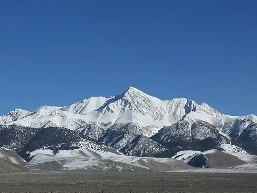
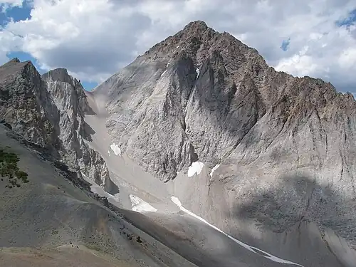
 Borah Peak
 -
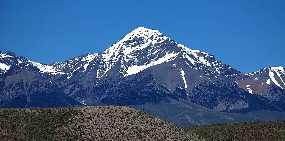 Diamond Peak
 -
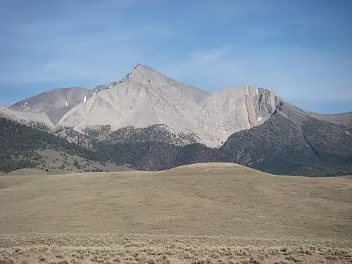
 Hyndman Peak
 -
 Castle Peak
 -
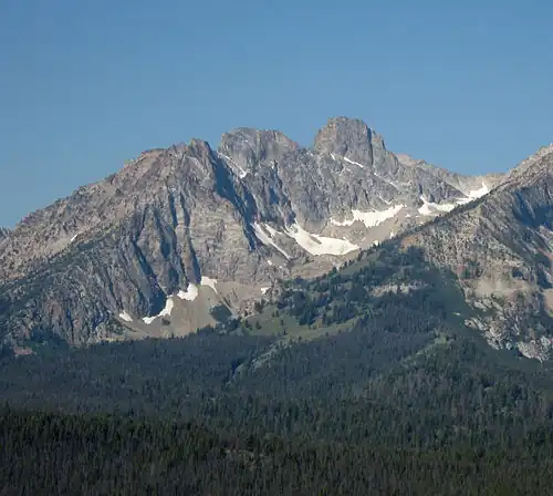 Thompson Peak
 -
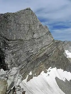
 Mount Regan
See also
- List of mountain peaks of North America
- List of mountain peaks of Greenland
- List of mountain peaks of Canada
- List of mountain peaks of the Rocky Mountains
- List of mountain peaks of the United States
- List of mountain peaks of Alaska
- List of mountain peaks of Arizona
- List of mountain peaks of California
- List of mountain peaks of Colorado
- List of mountain peaks of Hawaiʻi
- List of mountain peaks of Idaho
- List of mountain peaks of Montana
- List of mountain peaks of Nevada
- List of mountain peaks of Oregon
- List of mountain peaks of Utah
- List of mountain peaks of Washington (state)
- List of mountain peaks of Wyoming
- List of mountain peaks of México
- List of mountain peaks of Central America
- List of mountain peaks of the Caribbean
- Idaho
- Geography of Idaho
- Category:Mountains of Idaho
- Geography of Idaho
- Physical geography
- Topography
- Topographic elevation
- Topographic prominence
- Topographic isolation
- Topography
Notes
- ^ a b c The summit of Borah Peak is the highest point of the Lost River Range and the U.S. State of Idaho.
- ^ The elevation of Leatherman Peak includes an adjustment of +1.61 m (5.28 ft) from NGVD 29 to NAVD 88.
- ^ a b c The summit of Diamond Peak is the highest point of the Lemhi Range.
- ^ a b c The summit of Hyndman Peak is the highest point of the Pioneer Mountains.
- ^ a b c The summit of Castle Peak is the highest point of the White Cloud Mountains.
- ^ a b c The summit of Ryan Peak is the highest point of the Boulder Mountains.
- ^ The elevation of Glassford Peak includes an adjustment of +1.583 m (5.19 ft) from NGVD 29 to NAVD 88.
- ^ a b c The summit of Scott Peak is the highest point of the Beaverhead Mountain.
- ^ a b c The summit of Shelly Mountain is the highest point of the White Knob Mountains.
- ^ a b c The elevation of South Lost River Range high point includes an adjustment of +1.466 m (4.81 ft) from NGVD 29 to NAVD 88.
- ^ a b c The summit of Thompson Peak is the highest point of the Sawtooth Range.
- ^ a b c The summit of White Mountain West is the highest point of the Salmon River Mountains.
- ^ a b c The elevation of White Mountain West includes an adjustment of +1.567 m (5.14 ft) from NGVD 29 to NAVD 88.
- ^ The summit of Bromaghin Peak South is the highest point of the Smoky Mountains.
- ^ The elevation of Bromaghin Peak South includes an adjustment of +1.525 m (5 ft) from NGVD 29 to NAVD 88.
- ^ a b c The summit of Cache Peak is the highest point of the Albion Range.
- ^ The summit elevation of Vienna Benchmark includes a vertical offset of +0.914 m (3 ft) from the station benchmark.
- ^ a b c The summit of Mount Jefferson is the highest point of the Centennial Mountains.
- ^ a b c Mount Jefferson lies on the Continental Divide of the Americas between Idaho and Montana.
- ^ The elevation of Mount Regan includes an adjustment of +1.587 m (5.21 ft) from NGVD 29 to NAVD 88.
- ^ a b c The summit of Smoky Dome is the highest point of the Soldier Mountains.
- ^ a b c The summit of Mount McGuire is the highest point of the Bighorn Crags.
- ^ a b c The summit of Meade Peak is the highest point of the Preuss Range.
- ^ a b c Taylor Mountain lies on the Continental Divide of the Americas between Idaho and Montana.
- ^ a b c The summit of She Devil is the highest point of the Seven Devils Mountains.
- ^ a b c The elevation of She Devil includes an adjustment of +1.365 m (4.48 ft) from NGVD 29 to NAVD 88.
- ^ a b c The summit of Black Pine Mountains high point is the highest point of the Black Pine Mountains.
- ^ a b c The summit of North Loon Mountain is the highest point of the Lick Creek Range.
- ^ a b c The elevation of North Loon Mountain includes an adjustment of +1.3 m (4.27 ft) from NGVD 29 to NAVD 88.
- ^ a b c The summit of Oxford Peak is the highest point of the Bannock Range.
- ^ a b c The summit of Bonneville Peak is the highest point of the Portneuf Range.
- ^ a b c The elevation of Bonneville Peak includes an adjustment of +1.222 m (4.01 ft) from NGVD 29 to NAVD 88.
- ^ a b c The summit elevation of Sedgwick Peak includes a vertical offset of +0.61 m (2 ft) from the station benchmark.
- ^ a b The summit of Sturgill Peak is the highest point of the Hitt Mountains.
- ^ a b The elevation of South Selkirk Crest includes an adjustment of +1.42 m (4.66 ft) from NGVD 29 to NAVD 88.
- ^ a b The summit of Deep Creek Peak is the highest point of the Deep Creek Mountains.
- ^ a b The summit of Cinnabar Mountain is the highest point of the Owyhee Mountains.
References
- ^ This article defines a significant summit as a summit with at least 100 meters (328.1 feet) of topographic prominence, and a major summit as a summit with at least 500 meters (1640 feet) of topographic prominence. All summits in this article have at least 500 meters of topographic prominence. An ultra-prominent summit is a summit with at least 1500 meters (4921 feet) of topographic prominence.
- ^ All elevations in this article include an elevation adjustment from the National Geodetic Vertical Datum of 1929 (NGVD 29) to the North American Vertical Datum of 1988 (NAVD 88). For further information, please see this United States National Geodetic Survey note.
- ^ a b If the elevation or prominence of a summit is calculated as a range of values, the arithmetic mean is shown.
- ^ The topographic prominence of a summit is the topographic elevation difference between the summit and its highest or key col to a higher summit. The summit may be near its key col or quite far away. The key col for Denali in Alaska is the Isthmus of Rivas in Nicaragua, 7642 kilometers (4749 miles) away.
- ^ The topographic isolation of a summit is the great-circle distance to its nearest point of equal elevation.
- ^ a b c "BEAUTY RESET". Datasheet for NGS Station PZ0770. U.S. National Geodetic Survey. Retrieved June 14, 2016.
- ^ a b c "Borah Peak". Geographic Names Information System. United States Geological Survey, United States Department of the Interior.
- ^ a b c "Borah Peak". Peakbagger.com. Retrieved June 14, 2016.
- ^ a b c "Borah Peak". Bivouac.com. Retrieved June 14, 2016.
- ^ "Leatherman Peak". Geographic Names Information System. United States Geological Survey, United States Department of the Interior.
- ^ "Leatherman Peak". Peakbagger.com. Retrieved June 14, 2016.
- ^ "Leatherman Peak". Bivouac.com. Retrieved June 14, 2016.
- ^ a b c "DIAMOND RESET". Datasheet for NGS Station PZ0750. U.S. National Geodetic Survey. Retrieved June 14, 2016.
- ^ a b c "Diamond Peak". Geographic Names Information System. United States Geological Survey, United States Department of the Interior.
- ^ a b c "Diamond Peak". Peakbagger.com. Retrieved June 14, 2016.
- ^ a b c "Diamond Peak". Bivouac.com. Retrieved June 14, 2016.
- ^ a b c "HYNDMAN". Datasheet for NGS Station OZ0915. U.S. National Geodetic Survey. Retrieved June 14, 2016.
- ^ a b c "Hyndman Peak". Geographic Names Information System. United States Geological Survey, United States Department of the Interior.
- ^ a b c "Hyndman Peak". Peakbagger.com. Retrieved June 14, 2016.
- ^ a b c "Hyndman Peak". Bivouac.com. Retrieved June 14, 2016.
- ^ "MCCALEB". Datasheet for NGS Station PZ0768. U.S. National Geodetic Survey. Retrieved June 14, 2016.
- ^ "USGS Peak". Peakbagger.com. Retrieved June 14, 2016.
- ^ a b c "CASTLE". Datasheet for NGS Station QA0732. U.S. National Geodetic Survey. Retrieved June 14, 2016.
- ^ a b c "Castle Peak". Peakbagger.com. Retrieved June 14, 2016.
- ^ a b c "Castle Peak". Bivouac.com. Retrieved June 14, 2016.
- ^ a b c "RYAN". Datasheet for NGS Station OZ0926. U.S. National Geodetic Survey. Retrieved June 14, 2016.
- ^ a b c "Ryan Peak". Geographic Names Information System. United States Geological Survey, United States Department of the Interior.
- ^ a b c "Ryan Peak". Peakbagger.com. Retrieved June 14, 2016.
- ^ a b c "Ryan Peak". Bivouac.com. Retrieved June 14, 2016.
- ^ a b "BELL MTN". Datasheet for NGS Station PZ0753. U.S. National Geodetic Survey. Retrieved June 14, 2016.
- ^ a b "Bell Mountain". Geographic Names Information System. United States Geological Survey, United States Department of the Interior.
- ^ a b "Bell Mountain". Peakbagger.com. Retrieved June 14, 2016.
- ^ a b "Bell Mountain". Bivouac.com. Retrieved June 14, 2016.
- ^ "Glassford Peak". Geographic Names Information System. United States Geological Survey, United States Department of the Interior.
- ^ "Glassford Peak". Peakbagger.com. Retrieved June 14, 2016.
- ^ "Glassford Peak". Bivouac.com. Retrieved June 14, 2016.
- ^ a b c "SMILEY RESET". Datasheet for NGS Station OY0991. U.S. National Geodetic Survey. Retrieved June 14, 2016.
- ^ a b c "Smiley Mountain". Geographic Names Information System. United States Geological Survey, United States Department of the Interior.
- ^ a b c "Smiley Mountain". Peakbagger.com. Retrieved June 14, 2016.
- ^ a b c "Smiley Mountain". Bivouac.com. Retrieved June 14, 2016.
- ^ a b c "SCOTT PK". Datasheet for NGS Station PZ0705. U.S. National Geodetic Survey. Retrieved June 14, 2016.
- ^ a b c "Scott Peak". Geographic Names Information System. United States Geological Survey, United States Department of the Interior.
- ^ a b c "Scott Peak". Peakbagger.com. Retrieved June 14, 2016.
- ^ a b c "Scott Peak". Bivouac.com. Retrieved June 14, 2016.
- ^ a b c "BIG RESET". Datasheet for NGS Station PZ0764. U.S. National Geodetic Survey. Retrieved June 14, 2016.
- ^ a b c "Big Creek Peak". Geographic Names Information System. United States Geological Survey, United States Department of the Interior.
- ^ a b c "Big Creek Peak". Peakbagger.com. Retrieved June 14, 2016.
- ^ a b c "Big Creek Peak". Bivouac.com. Retrieved June 14, 2016.
- ^ a b c "SHELLY RESET". Datasheet for NGS Station OY0978. U.S. National Geodetic Survey. Retrieved June 14, 2016.
- ^ a b c "Shelly Mountain". Geographic Names Information System. United States Geological Survey, United States Department of the Interior.
- ^ a b c "Shelly Mountain". Peakbagger.com. Retrieved June 14, 2016.
- ^ a b c "Shelly Mountain". Bivouac.com. Retrieved June 14, 2016.
- ^ a b "DICKEY". Datasheet for NGS Station PZ0776. U.S. National Geodetic Survey. Retrieved June 14, 2016.
- ^ a b "Dickey Peak". Geographic Names Information System. United States Geological Survey, United States Department of the Interior.
- ^ a b "Dickey Peak". Peakbagger.com. Retrieved June 14, 2016.
- ^ a b "Dickey Peak". Bivouac.com. Retrieved June 14, 2016.
- ^ a b c "South Lost River Range high point". Peakbagger.com. Retrieved June 14, 2016.
- ^ a b c "South Lost River Range high point". Bivouac.com. Retrieved June 14, 2016.
- ^ a b c "LEM". Datasheet for NGS Station PZ0796. U.S. National Geodetic Survey. Retrieved June 14, 2016.
- ^ a b c "Lem Peak". Geographic Names Information System. United States Geological Survey, United States Department of the Interior.
- ^ a b c "Lem Peak". Peakbagger.com. Retrieved June 14, 2016.
- ^ a b c "SHEEP MTN". Datasheet for NGS Station QA0704. U.S. National Geodetic Survey. Retrieved June 14, 2016.
- ^ a b c "Sheep Mountain". Geographic Names Information System. United States Geological Survey, United States Department of the Interior.
- ^ a b c "Sheep Mountain". Peakbagger.com. Retrieved June 14, 2016.
- ^ a b c "Sheep Mountain". Bivouac.com. Retrieved June 14, 2016.
- ^ a b c "SADDLE". Datasheet for NGS Station OY0924. U.S. National Geodetic Survey. Retrieved June 14, 2016.
- ^ a b c "Saddle Mountain". Geographic Names Information System. United States Geological Survey, United States Department of the Interior.
- ^ a b c "Saddle Mountain". Peakbagger.com. Retrieved June 14, 2016.
- ^ a b c "Saddle Mountain". Bivouac.com. Retrieved June 14, 2016.
- ^ a b c "GOAT". Datasheet for NGS Station QA0805. U.S. National Geodetic Survey. Retrieved June 14, 2016.
- ^ a b c "Thompson Peak". Geographic Names Information System. United States Geological Survey, United States Department of the Interior.
- ^ a b c "Thompson Peak". Peakbagger.com. Retrieved June 14, 2016.
- ^ a b c "Thompson Peak". Bivouac.com. Retrieved June 14, 2016.
- ^ a b c "White Mountain West". Peakbagger.com. Retrieved June 14, 2016.
- ^ "Bromaghin Peak South". Geographic Names Information System. United States Geological Survey, United States Department of the Interior.
- ^ "Bromaghin Peak South". Peakbagger.com. Retrieved June 14, 2016.
- ^ "Bromaghin Peak South". Bivouac.com. Retrieved June 14, 2016.
- ^ a b c "CACHE". Datasheet for NGS Station NU1721. U.S. National Geodetic Survey. Retrieved June 14, 2016.
- ^ a b c "Cache Peak". Geographic Names Information System. United States Geological Survey, United States Department of the Interior.
- ^ a b c "Cache Peak". Peakbagger.com. Retrieved June 14, 2016.
- ^ a b c "Cache Peak". Bivouac.com. Retrieved June 14, 2016.
- ^ a b c "THE GENERAL RESET". Datasheet for NGS Station QA0744. U.S. National Geodetic Survey. Retrieved June 14, 2016.
- ^ a b c "The General". Peakbagger.com. Retrieved June 14, 2016.
- ^ a b c "The General". Bivouac.com. Retrieved June 14, 2016.
- ^ a b c "RAM RESET". Datasheet for NGS Station QA0717. U.S. National Geodetic Survey. Retrieved June 14, 2016.
- ^ a b c "Bald Mountain". Geographic Names Information System. United States Geological Survey, United States Department of the Interior.
- ^ a b c "Bald Mountain". Peakbagger.com. Retrieved June 14, 2016.
- ^ a b c "Bald Mountain". Bivouac.com. Retrieved June 14, 2016.
- ^ "VIENNA". Datasheet for NGS Station OZ0978. U.S. National Geodetic Survey. Retrieved June 14, 2016.
- ^ "Vienna Benchmark". Peakbagger.com. Retrieved June 14, 2016.
- ^ "Vienna Benchmark". Bivouac.com. Retrieved June 14, 2016.
- ^ a b c "SAWTELLE". Datasheet for NGS Station PY1196. U.S. National Geodetic Survey. Retrieved June 14, 2016.
- ^ a b c "Mount Jefferson". Geographic Names Information System. United States Geological Survey, United States Department of the Interior.
- ^ a b c "Mount Jefferson". Peakbagger.com. Retrieved June 14, 2016.
- ^ a b c "Mount Jefferson". Bivouac.com. Retrieved June 14, 2016.
- ^ "Mount Regan". Geographic Names Information System. United States Geological Survey, United States Department of the Interior.
- ^ "Mount Regan". Peakbagger.com. Retrieved June 14, 2016.
- ^ "Mount Regan". Bivouac.com. Retrieved June 14, 2016.
- ^ a b c "SMOKY". Datasheet for NGS Station OZ0878. U.S. National Geodetic Survey. Retrieved June 14, 2016.
- ^ a b c "Smoky Dome". Geographic Names Information System. United States Geological Survey, United States Department of the Interior.
- ^ a b c "Smoky Dome". Peakbagger.com. Retrieved June 14, 2016.
- ^ a b c "Smoky Dome". Bivouac.com. Retrieved June 14, 2016.
- ^ a b c "MOUNT MCGUIRE". Datasheet for NGS Station QZ0600. U.S. National Geodetic Survey. Retrieved June 14, 2016.
- ^ a b c "Mount McGuire". Geographic Names Information System. United States Geological Survey, United States Department of the Interior.
- ^ a b c "Mount McGuire". Peakbagger.com. Retrieved June 14, 2016.
- ^ a b c "PREUSS". Datasheet for NGS Station NT0536. U.S. National Geodetic Survey. Retrieved June 14, 2016.
- ^ a b c "Meade Peak". Geographic Names Information System. United States Geological Survey, United States Department of the Interior.
- ^ a b c "Meade Peak". Peakbagger.com. Retrieved June 14, 2016.
- ^ a b c "Meade Peak". Bivouac.com. Retrieved June 14, 2016.
- ^ a b c "GOAT MOUNTAIN". Datasheet for NGS Station PZ0737. U.S. National Geodetic Survey. Retrieved June 14, 2016.
- ^ a b c "Goat Mountain". Geographic Names Information System. United States Geological Survey, United States Department of the Interior.
- ^ a b c "Goat Mountain". Peakbagger.com. Retrieved June 14, 2016.
- ^ a b c "Goat Mountain". Bivouac.com. Retrieved June 14, 2016.
- ^ a b "PINYON". Datasheet for NGS Station QA0767. U.S. National Geodetic Survey. Retrieved June 14, 2016.
- ^ a b "Pinyon Peak". Geographic Names Information System. United States Geological Survey, United States Department of the Interior.
- ^ a b "Pinyon Peak". Peakbagger.com. Retrieved June 14, 2016.
- ^ a b "SLEEPING DEER". Datasheet for NGS Station QA0754. U.S. National Geodetic Survey. Retrieved June 14, 2016.
- ^ a b "Sleeping Deer Mountain". Geographic Names Information System. United States Geological Survey, United States Department of the Interior.
- ^ a b "Sleeping Deer Mountain". Peakbagger.com. Retrieved June 14, 2016.
- ^ a b "Sleeping Deer Mountain". Bivouac.com. Retrieved June 14, 2016.
- ^ a b c "GLO POST 10". Datasheet for NGS Station PY1198. U.S. National Geodetic Survey. Retrieved June 14, 2016.
- ^ a b c "Taylor Mountain". Geographic Names Information System. United States Geological Survey, United States Department of the Interior.
- ^ a b c "Taylor Mountain". Peakbagger.com. Retrieved June 14, 2016.
- ^ a b c "Taylor Mountain". Bivouac.com. Retrieved June 14, 2016.
- ^ a b c "She Devil". Geographic Names Information System. United States Geological Survey, United States Department of the Interior.
- ^ a b c "She Devil". Peakbagger.com. Retrieved June 14, 2016.
- ^ a b c "She Devil". Bivouac.com. Retrieved June 14, 2016.
- ^ a b c "BLACK". Datasheet for NGS Station AB3351. U.S. National Geodetic Survey. Retrieved June 14, 2016.
- ^ a b c "Black Pine Mountains high point". Peakbagger.com. Retrieved June 14, 2016.
- ^ a b c "North Loon Mountain". Geographic Names Information System. United States Geological Survey, United States Department of the Interior.
- ^ a b c "North Loon Mountain". Peakbagger.com. Retrieved June 14, 2016.
- ^ a b c "North Loon Mountain". Bivouac.com. Retrieved June 14, 2016.
- ^ a b c "OXFORD 2". Datasheet for NGS Station NU1561. U.S. National Geodetic Survey. Retrieved June 14, 2016.
- ^ a b c "Oxford Peak". Geographic Names Information System. United States Geological Survey, United States Department of the Interior.
- ^ a b c "Oxford Peak". Peakbagger.com. Retrieved June 14, 2016.
- ^ a b c "Oxford Peak". Bivouac.com. Retrieved June 14, 2016.
- ^ a b c "Bonneville Peak". Geographic Names Information System. United States Geological Survey, United States Department of the Interior.
- ^ a b c "Bonneville Peak". Peakbagger.com. Retrieved June 14, 2016.
- ^ a b c "Bonneville Peak". Bivouac.com. Retrieved June 14, 2016.
- ^ a b c "BALDY". Datasheet for NGS Station NT0605. U.S. National Geodetic Survey. Retrieved June 14, 2016.
- ^ a b c "Sedgwick Peak". Geographic Names Information System. United States Geological Survey, United States Department of the Interior.
- ^ a b c "Sedgwick Peak". Peakbagger.com. Retrieved June 14, 2016.
- ^ a b c "Sedgwick Peak". Bivouac.com. Retrieved June 14, 2016.
- ^ a b "SCOTCHMAN". Datasheet for NGS Station TO0961. U.S. National Geodetic Survey. Retrieved June 14, 2016.
- ^ a b "Scotchman Peak". Geographic Names Information System. United States Geological Survey, United States Department of the Interior.
- ^ a b "Scotchman Peak". Peakbagger.com. Retrieved June 14, 2016.
- ^ a b "Scotchman Peak". Bivouac.com. Retrieved June 14, 2016.
- ^ a b "HORN". Datasheet for NGS Station NU1590. U.S. National Geodetic Survey. Retrieved June 14, 2016.
- ^ a b "Elkhorn Peak". Geographic Names Information System. United States Geological Survey, United States Department of the Interior.
- ^ a b "Elkhorn Peak". Peakbagger.com. Retrieved June 14, 2016.
- ^ a b "Elkhorn Peak". Bivouac.com. Retrieved June 14, 2016.
- ^ a b "STIRGIL". Datasheet for NGS Station QB1393. U.S. National Geodetic Survey. Retrieved June 14, 2016.
- ^ a b "Sturgill Peak". Geographic Names Information System. United States Geological Survey, United States Department of the Interior.
- ^ a b "Sturgill Peak". Peakbagger.com. Retrieved June 14, 2016.
- ^ a b "BUFFALO". Datasheet for NGS Station QZ0737. U.S. National Geodetic Survey. Retrieved June 14, 2016.
- ^ a b "Buffalo Hump". Geographic Names Information System. United States Geological Survey, United States Department of the Interior.
- ^ a b "Buffalo Hump". Peakbagger.com. Retrieved June 14, 2016.
- ^ a b "Buffalo Hump". Bivouac.com. Retrieved June 14, 2016.
- ^ a b "South Selkirk Crest". Peakbagger.com. Retrieved June 14, 2016.
- ^ a b "QUEEN MTN". Datasheet for NGS Station TO0911. U.S. National Geodetic Survey. Retrieved June 14, 2016.
- ^ a b "Queen Mountain". Geographic Names Information System. United States Geological Survey, United States Department of the Interior.
- ^ a b "Queen Mountain". Peakbagger.com. Retrieved June 14, 2016.
- ^ a b "Queen Mountain". Bivouac.com. Retrieved June 14, 2016.
- ^ a b "KNOX". Datasheet for NGS Station NU1599. U.S. National Geodetic Survey. Retrieved June 14, 2016.
- ^ a b "Deep Creek Peak". Geographic Names Information System. United States Geological Survey, United States Department of the Interior.
- ^ a b "Deep Creek Peak". Peakbagger.com. Retrieved June 14, 2016.
- ^ a b "Deep Creek Peak". Bivouac.com. Retrieved June 14, 2016.
- ^ a b "SILVER". Datasheet for NGS Station NW0395. U.S. National Geodetic Survey. Retrieved June 14, 2016.
- ^ a b "Cinnabar Mountain". Geographic Names Information System. United States Geological Survey, United States Department of the Interior.
- ^ a b "Cinnabar Mountain". Peakbagger.com. Retrieved June 14, 2016.
External links
- United States Geological Survey (USGS)
- United States National Geodetic Survey (NGS)
- Bivouac.com
- Peakbagger.com
- Peaklist.org
- Peakware.com
- Summitpost.org
State of Idaho | |
|---|---|
Boise (capital) | |
| Topics |
|
| Society |
|
| Regions |
|
| Larger cities |
|
| Smaller cities |
|
| Counties |
|