Miankuh-e Moguyi Rural District
Miankuh-e Moguyi Rural District
Persian: دهستان ميان كوه موگوئي | |
|---|---|
Rural District | |
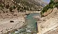
 Landscape in the village of Biabeh | |
 Miankuh-e Moguyi Rural District | |
| Coordinates: 32°42′N 49°49′E / 32.700°N 49.817°E[1][2] | |
| Country | Iran |
| Province | Chaharmahal and Bakhtiari |
| County | Kuhrang |
| District | Central |
| Established | 1993[3] |
| Capital | Khuyeh |
| Population (2016)[4] | |
• Total | 3,992 |
| Time zone | UTC+3:30 (IRST) |
Miankuh-e Moguyi Rural District (Persian: دهستان ميان كوه موگوئي) is in the Central District of Kuhrang County, Chaharmahal and Bakhtiari province, Iran.[5] Its capital is the village of Khuyeh.[3]
Demographics
Population
At the time of the 2006 National Census, the rural district's population was 3,781 in 624 households.[6] There were 3,570 inhabitants in 754 households at the following census of 2011.[7] The 2016 census measured the population of the rural district as 3,992 in 917 households. The most populous of its 16 villages was Sar Aqa Seyyed, with 1,698 people.[4]
Other villages in the rural district
Gallery
See also
![]() Iran portal
Iran portal
References
- ^ OpenStreetMap contributors (1 September 2025). "دهستان میانکوه موگویی, بخش مرکزی [Miankuh-e Moguyi Rural District, Central District], Kuhrang County, Chaharmahal and Bakhtiyari Province, Iran" (Map). OpenStreetMap (in Persian). Retrieved 1 September 2025.
- ^ "MRX8+XMV Khuyeh, Chaharmahal and Bakhtiari Province, Iran" (Map). Google Maps. Retrieved 1 September 2025.
- ^ a b Habibi, Hassan (3 March 1993) [تاریخ تصویب (Approval date) 12/12/1371 (Iranian Jalali calendar)]. ايجاد48واحددهستان درچنداستان كشور [Establishment of 48 rural districts in several provinces of the country]. سامانه ملی قوانین و مقررات [National System of Laws and Regulations] (in Persian). وزارت کشور [Ministry of the Interior]. کمیسیون سیاسی دفاعی هیأت دولت [Political Defense Commission of the Government Board]. تصويبنامه شماره ۹۳۸۰۸ /ت ۹۰۷ [Approval Letter Number 93808/T907]. Archived from the original on 28 November 2018. Retrieved 14 June 2025.
- ^ a b سرشماري عمومي نفوس و مسكن 1395 : استان چهارمحال و بختیاری [General Population and Housing Census 2016: Chaharmahal and Bakhtiari Province]. مرکز آمار ایران [Statistical Centre of Iran] (in Persian). Archived from the original (Excel) on 24 May 2019. Retrieved 19 December 2022.
- ^ Habibi, Hassan (18 July 2001) [تاریخ تصویب (Approval date) 1380/04/27 (Iranian Jalali calendar)]. تصویب نامه راجع به ایجاد و تأسیس شهرستان کوهرنگ [Decree on the creation and establishment of Kuhrang County]. لام تا کام [Lam ta Kam] (in Persian). وزارت کشور [Ministry of the Interior]. هیات وزیران [Council of Ministers]. شناسه [ID] 2B9AD588-58F4-4097-97E8-B406F301D97E. شماره دوره [Course number] 80. Archived from the original on 3 December 2023. Retrieved 1 September 2025.
- ^ سرشماري عمومي نفوس و مسكن 1385 : استان چهارمحال و بختیاری [General Population and Housing Census 2006: Chaharmahal and Bakhtiari Province]. مرکز آمار ایران [Statistical Centre of Iran] (in Persian). Archived from the original (Excel) on 20 September 2011. Retrieved 25 September 2022.
- ^ سرشماري عمومي نفوس و مسكن 1390 : استان چهارمحال و بختیاری [General Population and Housing Census 2011: Chaharmahal and Bakhtiari Province]. Iran Data Portal—Syracuse University (in Persian). مرکز آمار ایران [Statistical Centre of Iran]. Archived from the original (Excel) on 16 January 2023. Retrieved 19 December 2022.
Chaharmahal and Bakhtiari province, Iran | |||||||||||||||||||||||
|---|---|---|---|---|---|---|---|---|---|---|---|---|---|---|---|---|---|---|---|---|---|---|---|
| Capital |
|  | |||||||||||||||||||||
| Counties and cities |
| ||||||||||||||||||||||
| Landmarks |
| ||||||||||||||||||||||
| populated places |
| ||||||||||||||||||||||