Sar Aqa Seyyed
Sar Aqa Seyyed
Persian: سراقاسيد | |
|---|---|
Village | |
 Sar Aqa Seyyed | |
 Sar Aqa Seyyed | |
| Coordinates: 32°39′30″N 49°51′52″E / 32.65833°N 49.86444°E[1] | |
| Country | Iran |
| Province | Chaharmahal and Bakhtiari |
| County | Kuhrang |
| District | Central |
| Rural District | Miankuh-e Moguyi |
| Population (2016)[2] | |
• Total | 1,698 |
| Time zone | UTC+3:30 (IRST) |
Sar Aqa Seyyed (Persian: سراقاسيد)[a] is a village in Miankuh-e Moguyi Rural District[4] of the Central District in Kuhrang County, Chaharmahal and Bakhtiari province, Iran.
Demographics
Ethnicity
The village is populated by Lurs.[5]
Population
At the time of the 2006 National Census, the village's population was 1,360 in 208 households.[6] The following census in 2011 counted 1,236 people in 275 households.[7] The 2016 census measured the population of the village as 1,698 people in 380 households. It was the most populous village in its rural district.[2]
Architecture
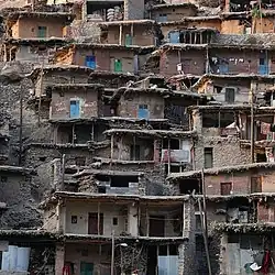
The village is named after Aqa Seyyed shrine. It is known for its unusual architecture. Its interconnected buildings are built into the surrounding mountain. The roofs of the buildings serve as courtyards and streets of the buildings above. Most of the homes have no windows and only one door.[8][9]
Because of the similarity of architecture, Sar Aqa Seyyed village is called The Masuleh of Zagros. Also, tourists explore this village for its nomads.[10]
External links
 Media related to Sar Aqa Seyyed at Wikimedia Commons
- "Sar Aqa Seyyed: Village with Spectacular Architecture". Iran Student Correspondence Association. 15 September 2017.
- Sar Agha Seyed: A village in the heart of nature at Amazing Iran Media
![]() Iran portal
Iran portal
Notes
References
- ^ OpenStreetMap contributors (30 August 2024). "سراقاسید, دهستان میانکوه موگویی, بخش مرکزی [Sar Aqa Seyyed, Miankuh-e Moguyi Rural District, Central District], Kuhrang County, Chaharmahal and Bakhtiyari Province, Iran" (Map). OpenStreetMap (in Persian). Retrieved 30 August 2024.
- ^ a b سرشماري عمومي نفوس و مسكن 1395 : استان چهارمحال و بختیاری [General Population and Housing Census 2016: Chaharmahal and Bakhtiari Province]. مرکز آمار ایران [Statistical Centre of Iran] (in Persian). Archived from the original (Excel) on 24 May 2019. Retrieved 19 December 2022.
- ^ Sar Aqa Seyyed can be found at GEOnet Names Server, at this link, by opening the Advanced Search box, entering "-3082511" in the "Unique Feature Id" form, and clicking on "Search Database".
- ^ Habibi, Hassan (3 March 1993) [تاریخ تصویب (Approval date) 12/12/1371 (Iranian Jalali calendar)]. ايجاد48واحددهستان درچنداستان كشور [Establishment of 48 rural districts in several provinces of the country]. سامانه ملی قوانین و مقررات [National System of Laws and Regulations] (in Persian). وزارت کشور [Ministry of the Interior]. کمیسیون سیاسی دفاعی هیأت دولت [Political Defense Commission of the Government Board]. تصويبنامه شماره ۹۳۸۰۸ /ت ۹۰۷ [Approval Letter Number 93808/T907]. Archived from the original on 28 November 2018. Retrieved 14 June 2025.
- ^ "Language distribution: Chahar Mahal va Bakhtiari Province". Iran Atlas. Retrieved 25 March 2021.
- ^ سرشماري عمومي نفوس و مسكن 1385 : استان چهارمحال و بختیاری [General Population and Housing Census 2006: Chaharmahal and Bakhtiari Province]. مرکز آمار ایران [Statistical Centre of Iran] (in Persian). Archived from the original (Excel) on 20 September 2011. Retrieved 25 September 2022.
- ^ سرشماري عمومي نفوس و مسكن 1390 : استان چهارمحال و بختیاری [General Population and Housing Census 2011: Chaharmahal and Bakhtiari Province]. Iran Data Portal—Syracuse University (in Persian). مرکز آمار ایران [Statistical Centre of Iran]. Archived from the original (Excel) on 16 January 2023. Retrieved 19 December 2022.
- ^ "A mountain village built on rooftops". Tehran Times. 25 December 2017.
- ^ "Iran's Farsian: A Village on Rooftops". Tasnim News Agency. 29 October 2017.
- ^ "Sar Agha Seyed Village features special construction". ISNA. 21 August 2019. Retrieved 20 March 2020.
Chaharmahal and Bakhtiari province, Iran | |||||||||||||||||||||||
|---|---|---|---|---|---|---|---|---|---|---|---|---|---|---|---|---|---|---|---|---|---|---|---|
| Capital |
|  | |||||||||||||||||||||
| Counties and cities |
| ||||||||||||||||||||||
| Landmarks |
| ||||||||||||||||||||||
| populated places |
| ||||||||||||||||||||||