GL postcode area
Gloucester | |
|---|---|
 GL | |
| Coordinates: 51°49′59″N 2°10′52″W / 51.833°N 2.181°W | |
| Country | United Kingdom |
| Postcode area | GL |
| Postcode area name | Gloucester |
| Post towns | 28 |
| Postcode districts | 27 |
| Postcode sectors | 117 |
| Postcodes (live) | 21,027 |
| Postcodes (total) | 28,597 |
| Statistics as at May 2020[1] | |
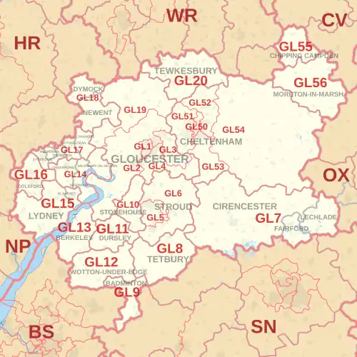
The GL postcode area, also known as the Gloucester postcode area,[2] is a group of 27 postcode districts in south-west England and a very small part of south-east Wales, within 28 post towns. These cover most of Gloucestershire, including Gloucester, Cheltenham, Stroud, Cirencester, Tewkesbury, Badminton, Berkeley, Blakeney, Chipping Campden, Cinderford, Coleford, Drybrook, Dursley, Dymock, Fairford, Lechlade, Longhope, Lydbrook, Lydney, Mitcheldean, Moreton-in-Marsh, Newent, Newnham, Ruardean, Stonehouse, Tetbury, Westbury-on-Severn and Wotton-under-Edge. The area also covers very small parts of Herefordshire, Worcestershire, Warwickshire, Oxfordshire and Wiltshire, while the GL16 district extends across the Welsh border to cover a very small part of Monmouthshire.
The area's districts are numbered sequentially from GL1 to GL20, then from GL50 to GL56 for Cheltenham and settlements immediately around and to its east.
GL17 has the most alternative post towns in England: covering an upper part of the Forest of Dean studded with isolated large villages, five are recognised as post towns within one postcode district.
Coverage
The approximate coverage of the postcode districts:
| Postcode district | Post town | Coverage | Local authority area(s) |
|---|---|---|---|
| GL1 | GLOUCESTER | The Docks, Central Gloucester, Kingsholm | Gloucester |
| GL2 | GLOUCESTER | Arlingham, Cambridge, Churcham, Churchdown, Down Hatherley, Elmore, Framilode, Frampton on Severn, Hardwicke, Hempsted, Highnam, Kingsway, Longford, Longlevens, Longney, Maisemore, Minsterworth, Moreton Valence, Norton, Over, Podsmead, Priors Norton, Quedgeley, Rudford, Sandhurst, Saul, Slimbridge, Tibberton (east), Twigworth, Walham, Waterwells Business Park, Whitminster | Gloucester, Stroud, Tewkesbury, Forest of Dean |
| GL3 | GLOUCESTER | Barnwood, Brockworth, Churchdown, Coopers Hill, Gloucester Business Park, Great Witcombe, Hucclecote, Innsworth, Little Witcombe,[a] Witcombe[b] | Tewkesbury, Gloucester, Stroud |
| GL4 | GLOUCESTER | Abbeydale, Abbeymead, Barnwood, Birdlip, Brimpsfield, Brookthorpe, Cranham, Harescombe, Matson, Tuffley, Upton St Leonards, Whaddon[c] | Gloucester, Stroud, Cotswold |
| GL5 | STROUD | Amberley, Bourne, Bowbridge, Brimscombe, Burleigh, Butterrow Hill, Cainscross, Cashes Green, Dudbridge, Dunkirk Mills, Ebley, Gaineys Well, Inchbrook, Kingscourt, Lightpill, Little London, Middle Leazes, North Woodchester, Paganhill, Randwick, Rodborough, Rodborough Common, Selsley, Selsley East, Selsley Hill, Selsley West, South Woodchester, Thrupp, Uplands,[d] Wallbridge, Walls Quarry, Woodchester | Stroud |
| GL6 | STROUD | Aston Down, Bell Pitch, Bird in Hand, Bisley, Bournes Green, Box, Brownshill, Bussage, Chalford, Chalford Hill, Eastcombe, Edge, Edgeworth, Elcombe, Far Oakridge, Far Westrip, Forest Green, Frampton Mansell, France Lynch, Horsley, Lower Kitesnest, Lypiatt, Middle Lypiatt, Middle Spring, Minchinhampton, Miserden, Nailsworth, Oakridge, Oakridge Lynch, Old Neighbouring, Painswick, Painswick Beacon, Pitchcombe, Randwick, Ruscombe,[e] Sheepscombe, Slad, Stancombe, The Camp, Upper Kitesnest, Westrip, Whiteshill, Whiteway | Stroud, Cotswold |
| GL7 | CIRENCESTER | Ampney Crucis, Ampney Knowle, Ampney St Mary, Ampney St Peter, Bagendon, Barnsley, Baunton, Bibury, Calmsden, Cerney Wick, Coates, Coln St. Aldwyns, Daglingworth, Bisley-with-Lypiatt, Down Ampney, Driffield, Duntisbourne Abbots, Duntisbourne Leer, Duntisbourne Rouse, Eastleach, Ewen, Harnhill, Hatherop, Honeycombe Leaze, Kemble, Kemble Wick, Love Lane Industrial Estate, Lower Norcote, Marsden, Meysey Hampton, Middle Duntisbourne, Norcote, North Cerney, North Cerney Downs, Perrotts Brook, Poole Keynes, Poulton, Preston, Quenington, Rapsgate, Ready Token, Rendcomb, Rodmarton, Sapperton, Shorncote, Siddington, Somerford Keynes, South Cerney, Stratton, Tarlton,[f] Tunley, Upper Up, Whiteway, Winson, Winstone, Woodmancote | Cotswold, Stroud, Wiltshire |
| FAIRFORD | Dudgrove, Dunfield, Kempsford, Totterdown, Whelford | Cotswold | |
| LECHLADE | Broadwell, Claydon, Claydon Pike, Downington, Filkins, Fyfield, Kelmscott, Kencot, Langford, Little Faringdon, Little London, Southrop, Thornhill, Warrens Cross | Cotswold, West Oxfordshire, Vale of White Horse | |
| GL8 | TETBURY | Ashley, Avening, Babdown, Bagpath, Beverston, Calcot, Chavenage, Cherington, Culkerton, Doughton, Estcourt, Ilsom, Kingscote, Knockdown,[g] Lasborough, Leighterton, Little Larkhill, Long Furlong, Long Newnton, Newington, Shipton Moyne, Trull, Tetbury Upton, Upton, Westonbirt, Willesley | Cotswold, Stroud, Wiltshire |
| GL9 | BADMINTON | Acton Turville, Didmarton, Dunkirk, Hawkesbury, Hawkesbury Common, Hawkesbury Upton, Inglestone Common, Little Badminton, Petty France, Tormarton | South Gloucestershire, Cotswold, Stroud, Wiltshire |
| GL10 | STONEHOUSE | Bridgend, Colethrop, Eastington, Frocester, Haresfield, Kings Stanley, Leonard Stanley, Lower Mills, Nastend, Newtown, Nupend, Nympsfield, Oldends, Oxlynch, Ryeford, Standish, Standish Park, Stanley Downton, Stroudwater Business Park, Westend | Stroud |
| GL11 | DURSLEY | Ashmead Green, Bull Pitch, Cam, Coaley, Norman Hill, North Nibley, Owlpen, Sandpits, Stancombe, Stinchcombe, Tilsdown, Uley, Upper Wick, Wick,[h] Woodfield, Woodmancote | Stroud |
| GL11 | WOTTON-UNDER-EDGE | non-geographic[3][4] | |
| GL12 | WOTTON-UNDER-EDGE | Alderley, Bagstone, Bibstone, Bournstream, Bowcott, Bradley Green, Buckover, Charfield, Coombe, Cromhall, Cutts Heath, Damery, Falfield, Hall End, Heathend, Hillesley, Howley, Huntingford, Kingswood, Leyhill, Michaelwood, Milbury Heath, Old Town, Ozleworth, Southend, Swinhay, Synwell, Tabernacle Pitch, Tortworth, Tresham, Tytherington, Whitfield, Wickwar, Woodend, Wortley | Stroud, South Gloucestershire, Cotswold |
| GL13 | BERKELEY | Abwell, Alkington, Berkeley Heath, Berrycroft, Bevington, Blackhall, Breadstone, Clapton, Hainses, Halmore, Ham, Ham Green, Hamfields, Hill, Hinton, Hystfield, Lower Stone, Mobley New Brookend, Newport, Newtown, Old Brookend, Pitbrook, Purton, Rockhampton, Sharpness, Stone, Wanswell, Woodford | Stroud, South Gloucestershire |
| GL14 | CINDERFORD | Buckshaft, Denecroft, Forest Vale Industrial Estate, Hawkwell Green, Littledean, Lower Soudley, Ruspidge, Soudley, Trafalgar, Upper Soudley, Whimsey | Forest of Dean |
| NEWNHAM | Awre, Blaize Bailey, Broadoak, Bullo Pill, Elton, Flaxley, Pope's Hill, Ruddle | ||
| WESTBURY-ON-SEVERN | Adsett, Bollow, Chaxhill, Grange Court, Ley, Northwood Green, Rodley, Walmore Common, Wintles Hill | ||
| GL15 | LYDNEY | Allastone,[i] Alvington, Aylburton, Bream, Hewelsfield, Lower Meend, Lower Yorkley, Netherend, Oldcroft, Parkend, Pillowell, St. Briavels, Viney Hill, Viney Woodside, Whitecroft, Woolaston, Yorkley, Yorkley Slade | Forest of Dean |
| BLAKENEY | Blakeney Hill, Bradley Hill, Etloe, Upper Etloe | ||
| GL16 | COLEFORD | Bakers Hill,[j] Berry Hill, Broadwell, Cannop,[k] Christchurch, Clearwell, Coalway, Edge End, Ellwood, English Bicknor, Five Acres,[l] Gorsty Knoll, Hillersland,[m] Joyford, Joyford Hill,[n] Little Drybrook,[o] Lower Berry Hill,[p] Lower Milkwall,[q] Mile End, Milkwall, Mushet Industrial Park, Newland, Ready Penny,[r] Shortstanding, Sling, Speech House, Staunton, Symonds Yat Rock, Tufthorn | Forest of Dean, Monmouthshire |
| GL17 | LYDBROOK | Central Lydbrook, Joys Green, Lower Lydbrook, Upper Lydbrook, Worrall Hill | Forest of Dean, Herefordshire |
| RUARDEAN | Ruardean Woodside, The Pludds | ||
| DRYBROOK | Brierley, Harrow Hill, Ruardean Hill | ||
| MITCHELDEAN | Lower Shapridge, Plump Hill, Wigpool | ||
| LONGHOPE | Blaisdon, Little London, May Hill | ||
| GL18 | NEWENT | Castle Tump, Cliffords Mesne, Four Oaks, Great Boulsdon, Highleadon, Hillend Green, Kilcot, Lower Boulsdon, Malswick, Oxenhall, Pool Hill, Upleadon | Forest of Dean, Herefordshire |
| DYMOCK | Broomsgreen, Greenway, Hallwood Green, Kempley, Ketford, Knights Green, Leddington, Ryton, Tillers Green | ||
| GL19 | GLOUCESTER | Apperley, Ashleworth, Birdwood, Chaceley, Coombe Hill, Corse, Corse Lawn, Deerhurst, Deerhurst Walton, Eldersfield, Forthampton, Hartpury, Hasfield, Huntley, Lower Apperley, Pendock, Redmarley, Staunton, Taynton, The Leigh,[s] Tibberton (west), Tirley, Walton Hill | Forest of Dean, Tewkesbury, Malvern Hills |
| GL20 | TEWKESBURY | Alderton, Alstone, Alstone Fields, Ashchurch, Aston Cross, Aston-on-Carrant, Back of Avon, Beckford, Bredon, Bredons Hardwick, Bredons Norton, Bushley, Claydon, Conderton, Fiddington, Grafton, Great Washbourne, Homedowns, Kemerton, Kinsham, Little Washbourne, Longdon, Natton Northway, Overbury, Pamington, Ripple, Shuthonger, Teddington, Tewkesbury Business Park, Tredington, Twyning, Uckinghall, Walton Cardiff, Westmancote | Tewkesbury, Malvern Hills, Wychavon |
| GL50 | CHELTENHAM | Montpellier, Lansdown, St. Pauls | Cheltenham, Gloucestershire |
| GL51 | CHELTENHAM | Badgeworth, Bamfurlong, Bentham,[t] Boddington, Cheltenham Trade Park, Elmstone Hardwicke, Gloucestershire Airport, Hayden,[u] Kingsditch Trading Estate, Knightsbridge, Leckhampton, Little Shurdington,[v] Shurdington, St. Marks,[w] Staverton, Staverton Technology Park, Swindon Village, The Reddings,[x] Uckington, Up Hatherley, Warden Hill | Cheltenham, Gloucestershire |
| GL52 | CHELTENHAM | Prestbury, Battledown, Bishops Cleeve, Charlton Kings, Cleeve Hill, Gotherington, Oxenton, Prestbury, Southam, Stoke Orchard, Woodmancote, Woodmancote Park | Cheltenham, Tewkesbury |
| GL53 | CHELTENHAM | Caudle Green,[y] Charlton Kings, Coberley, Coberley Village, Colesbourne, Cowley, Elkstone, Leckhampton, Leckhampton Hill, Seven Springs, Syde, Ullenwood, Upper Coberley | Cheltenham, Cotswold, Gloucestershire |
| GL54 | CHELTENHAM | Aldsworth, Andoversford, Bourton-on-the-Water, Brockhampton, Calcot, Charlton Abbotts, Charlton Kings, Chedworth, Clapton, Cold Aston, Coln Rogers, Coln St. Dennis, Compton Abdale, Condicote, Cutsdean, Didbrook, Eastington, Farmington, Fossebridge, Great Rissington, Greet,[z] Gretton, Guiting Power, Hailes, Hampnett, Hawling, Hazleton, Icomb, Little Rissington, Lower Chedworth,[aa] Lower Coscombe, Lower Dowdeswell, Lower Slaughter, Lower Swell, Maugersbury, Middle Chedworth,[ab] Naunton, Northleach, Notgrove, Old Hinchwick,[ac] Salperton, Sevenhampton, Sherborne, Shipton Oliffe, Stanley Pontlarge, Stanway, Stow on the Wold, Temple Guiting, Toddington, Turkdean, Upper Dowdeswell, Upper Rissington, Upper Slaughter, Upper Swell, Whittington, Winchcombe, Withington, Wood Stanway, Wyck Rissington, Yanworth | Cotswold, Gloucestershire, Cheltenham |
| GL55 | CHIPPING CAMPDEN | Aston Sub Edge, Broad Campden, Burnt Norton,[ad] Charingworth,[ae] Ebrington, Hidcote Bartrim, Hidcote Boyce,[af] Mickleton, Paxford, Weston-Subedge | Cotswold, Stratford-on-Avon |
| GL56 | MORETON-IN-MARSH | Adlestrop, Aston Magna, Barton-on-the-Heath, Batsford, Blockley, Bourton on the Hill, Broadwell, Chastleton, Daylesford, Donnington, Dorn, Draycott, Evenlode, Little Compton,[ag] Longborough, Lower Lemington, Oddington, Old Town, Sezincote, Snowshill Hill,[ah] Springhill,[ai] Stretton-on-Fosse, Todenham, Upper Oddington | Cotswold, Stratford-on-Avon, West Oxfordshire, Gloucestershire |
- ^ includes GL3 4SX
- ^ includes GL3 4SJ
- ^ includes GL4 0UA
- ^ includes GL5 1GR
- ^ includes GL6 6BU
- ^ includes GL7 6FH
- ^ includes GL8 8QY
- ^ includes GL11 6DA
- ^ includes GL15 4EY
- ^ includes GL16 7QB
- ^ includes GL16 7EH
- ^ includes GL16 7QL
- ^ includes GL16 7NX
- ^ includes GL16 7NX
- ^ includes GL16 8LP
- ^ includes GL16 8QG
- ^ includes GL16 7LF
- ^ includes GL16 7NX
- ^ includes GL19 4AA
- ^ includes GL51 4TZ
- ^ includes GL51 0FJ
- ^ includes GL51 4AF
- ^ includes GL51 7AH
- ^ includes GL51 6DR
- ^ includes GL53 9PR
- ^ includes GL54 5BG
- ^ includes GL54 4AN
- ^ includes GL54 4AJ
- ^ includes GL54 1EU
- ^ includes GL55 6PR
- ^ includes GL55 6NR
- ^ includes GL55 6LT
- ^ includes GL56 0SF
- ^ includes GL56 9TH
- ^ includes GL56 9TW
Map
See also
References
- ^ "ONS Postcode Directory Version Notes" (ZIP). National Statistics Postcode Products. Office for National Statistics. May 2020. Table 2. Retrieved 19 June 2020. Coordinates from mean of unit postcode points, "Code-Point Open". OS OpenData. Ordnance Survey. February 2012. Retrieved 21 April 2012.
- ^ Royal Mail, Address Management Guide (2004)
- ^ "Non Geographic Codes" (PDF). Royal Mail Address Management Unit. July 2012. Archived from the original (PDF) on 16 September 2012. Retrieved 20 December 2012.
- ^ "New sectors and localities to 14 December 2012" (PDF). Royal Mail Address Management Unit. 20 December 2012. Archived from the original (PDF) on 2 February 2015. Retrieved 20 December 2012.