HP postcode area
Template:Attached KML/HP postcode area
KML is from Wikidata
Hemel Hempstead | |
|---|---|
 HP | |
| Coordinates: 51°43′23″N 0°41′17″W / 51.723°N 0.688°W | |
| Country | United Kingdom |
| Postcode area | HP |
| Postcode area name | Hemel Hempstead |
| Post towns | 11 |
| Postcode districts | 24 |
| Postcode sectors | 77 |
| Postcodes (live) | 13,915 |
| Postcodes (total) | 21,705 |
| Statistics as at May 2020[1] | |
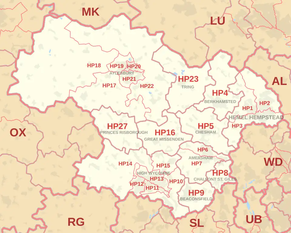
The HP postcode area, also known as the Hemel Hempstead postcode area,[2] is a group of twenty-four postcode districts in England, within eleven post towns. These cover south-west Hertfordshire (including Hemel Hempstead, Berkhamsted and Tring) and central Buckinghamshire (including Aylesbury, High Wycombe, Beaconsfield, Amersham, Chalfont St Giles, Chesham, Great Missenden and Princes Risborough).
Mail for this area is sorted at the Home Counties North Mail Centre in Hemel Hempstead.
Coverage
The approximate coverage of the postcode districts:
| Postcode district | Post town | Coverage | Local authority area(s) |
|---|---|---|---|
| HP1 | HEMEL HEMPSTEAD | Bourne End, Boxmoor, Chaulden, Fields End, Gadebridge, Great Gaddesden, Nettleden, Piccotts End, Water End, Warner's End | Dacorum |
| HP2 | HEMEL HEMPSTEAD | Gaddesden Row,[a] Piccotts End, Grovehill, Adeyfield, Hemel Hempstead Industrial Estate[b] | Dacorum |
| HP3 | HEMEL HEMPSTEAD | Apsley, Bovingdon, Felden, Flaunden, Hemel Hempstead, Leverstock Green | Dacorum |
| HP4 | BERKHAMSTED | Berkhamsted, Dagnall, Dudswell, Little Gaddesden, Northchurch, Potten End, Ringshall | Dacorum, Buckinghamshire |
| HP5 | CHESHAM | Chesham, Ashley Green, Bellingdon, Botley, Chartridge, Hawridge, Latimer, Lye Green, Newtown, Waterside, Whelpley Hill | Buckinghamshire |
| HP6 | AMERSHAM | Amersham (north), Chesham Bois, Hyde Heath, Little Chalfont (north) | Buckinghamshire |
| HP7 | AMERSHAM | Amersham (south), Coleshill, Little Chalfont (west and centre), Little Missenden, Penn Street, Winchmore Hill | Buckinghamshire |
| HP8 | CHALFONT ST. GILES | Chalfont St Giles, Little Chalfont (south) | Buckinghamshire |
| HP9 | BEACONSFIELD | Beaconsfield, Forty Green, Holtspur, Jordans, Knotty Green, Seer Green | Buckinghamshire |
| HP10 | HIGH WYCOMBE | High Wycombe, Flackwell Heath, Handy Cross, Hedsor, Loudwater, Penn, Tylers Green, Wooburn, Wooburn Green, Wooburn Moor | Buckinghamshire |
| HP11 | HIGH WYCOMBE | Wycombe Marsh | Buckinghamshire |
| HP12 | HIGH WYCOMBE | High Wycombe, Booker, Sands | Buckinghamshire |
| HP13 | HIGH WYCOMBE | High Wycombe, Downley, Totteridge | Buckinghamshire |
| HP14 | HIGH WYCOMBE | Beacon's Bottom, Bledlow Ridge, Bolter End, Bradenham, Cadmore End, Hughenden Valley, Ibstone, Lane End, Naphill, Northend, Stokenchurch, The City, Upper North Dean, West Wycombe | Buckinghamshire |
| HP15 | HIGH WYCOMBE | Cryers Hill, Great Kingshill, Hazlemere, Holmer Green, Hughenden Valley | Buckinghamshire |
| HP16 | GREAT MISSENDEN | Great Missenden, Ballinger, The Lee, Little Hampden, Little Kingshill, Prestwood, South Heath | Buckinghamshire |
| HP17 | AYLESBURY | Aston Sandford, Bishopstone, Butler's Cross, Dinton, Dorton, Ellesborough, Ford, Great and Little Kimble, Kingsey, Haddenham, Meadle, Nash Lee, Stone, Upton, Westlington | Buckinghamshire |
| HP18 | AYLESBURY | Ashendon, Berryfields, Boarstall, Brill, Chearsley, Chilton, Cuddington, Dorton, Easington, Edgcott, Grendon Underwood, Ickford, Kingswood, Long Crendon, Lower Winchendon, Ludgershall, Oakley, Shabbington, Upper Winchendon, Waddesdon, Westcott, Worminghall, Wotton Underwood | Buckinghamshire |
| HP19 | AYLESBURY | Aylesbury, Berryfields, Buckingham Park, Fairford Leys, Prebendal Farm, Quarrendon, Watermead | Buckinghamshire |
| HP20 | AYLESBURY | Aylesbury, Aylesbury Town Centre, Broughton, Elmhurst | Buckinghamshire |
| HP21 | AYLESBURY | Aylesbury, Bedgrove, Elm Farm, Queens Park, Southcourt, Walton, Walton Court | Buckinghamshire |
| HP22 | AYLESBURY | Aston Abbotts, Aston Clinton, Bierton, Buckland, Drayton Beauchamp, Dunsmore, Halton, Hardwick, Hulcott, North Lee, Nup End, Oving, Pitchcott, Quainton, Rowsham, Stoke Mandeville, Weedon, Wendover, Weston Turville, Whitchurch, Wingrave | Buckinghamshire |
| HP22 | PRINCES RISBOROUGH | non-geographic[3][4] | |
| HP23 | TRING | Aldbury, Buckland Common, Cholesbury, Hastoe, Long Marston, Marsworth, New Mill, Puttenham, St Leonards, Tring, Wigginton, Wilstone | Dacorum, Buckinghamshire |
| HP27 | PRINCES RISBOROUGH | Askett, Bledlow, Ilmer, Lacey Green, Longwick, Loosley Row, Monks Risborough, Owlswick, Pitch Green, Princes Risborough, Saunderton, Speen | Buckinghamshire |
Map
Template:Attached KML/HP postcode area
KML is from Wikidata
See also
References
- ^ "ONS Postcode Directory Version Notes" (ZIP). National Statistics Postcode Products. Office for National Statistics. May 2020. Table 2. Retrieved 19 June 2020. Coordinates from mean of unit postcode points, "Code-Point Open". OS OpenData. Ordnance Survey. February 2012. Retrieved 21 April 2012.
- ^ Royal Mail, Address Management Guide, (2004)
- ^ "Non Geographic Codes" (PDF). Royal Mail Address Management Unit. July 2012. Archived from the original (PDF) on 16 September 2012. Retrieved 20 December 2012.
- ^ "New sectors and localities to 14 December 2012" (PDF). Royal Mail Address Management Unit. 20 December 2012. Archived from the original (PDF) on 2 February 2015. Retrieved 20 December 2012.