SP postcode area
Template:Attached KML/SP postcode area
KML is from Wikidata
Salisbury | |
|---|---|
 SP | |
| Coordinates: 51°06′14″N 1°47′35″W / 51.104°N 1.793°W | |
| Country | United Kingdom |
| Postcode area | SP |
| Postcode area name | Salisbury |
| Post towns | 6 |
| Postcode districts | 11 |
| Postcode sectors | 47 |
| Postcodes (live) | 8,571 |
| Postcodes (total) | 11,348 |
| Statistics as at May 2020[1] | |
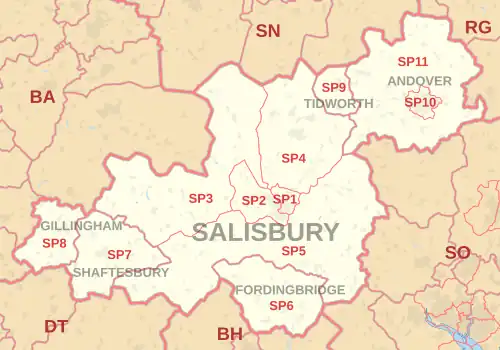
The SP postcode area, also known as the Salisbury postcode area,[2] is a group of eleven postcode districts in southern England, within six post towns. These cover south Wiltshire (including Salisbury and Tidworth) and parts of north Dorset (including Gillingham and Shaftesbury) and west Hampshire (including Andover and Fordingbridge).
The letters in the postcode refer to the Salisbury Plain, a plateau within the postcode area.
Coverage
The approximate coverage of the postcode districts:
| Postcode district | Post town | Coverage | Local authority area(s) |
|---|---|---|---|
| SP1 | SALISBURY | Central Salisbury and northern suburbs: Laverstock, Stratford-sub-Castle | Wiltshire |
| SP2 | SALISBURY | Salisbury west suburbs, Quidhampton, Netherhampton, Wilton, Great Wishford | Wiltshire |
| SP3 | SALISBURY | Tisbury, Shrewton, Hindon, Chilmark, East Knoyle, Dinton | Wiltshire |
| SP4 | SALISBURY | Amesbury, Durrington, Laverstock and Ford | Wiltshire |
| SP5 | SALISBURY | Rural parishes southwest, south and east of Salisbury: Alderbury, Alvediston, Ashmore, Bishopstone, Bowerchalke, Britford, Broad Chalke, Clarendon, Coombe Bissett, Downton, Ebbesbourne Wake, Grimstead, Landford, Odstock, Pitton, Redlynch, Sixpenny Handley, Stratford Tony, Tollard Royal, West Dean, West Tytherley, Whiteparish, Winterslow | Dorset, Wiltshire, New Forest |
| SP6 | FORDINGBRIDGE | Fordingbridge, Alderholt, Rockbourne, Martin | New Forest, Dorset |
| SP7 | SHAFTESBURY | Shaftesbury, Compton Abbas, Fontmell Magna, Donhead St Andrew, Donhead St Mary, Berwick St John, Motcombe | Dorset, Wiltshire |
| SP8 | GILLINGHAM | Gillingham, Stour Provost, East Stour, West Stour, Kington Magna, Buckhorn Weston, Milton on Stour, Bourton | Dorset |
| SP9 | TIDWORTH | Tidworth, Shipton Bellinger | Wiltshire, Test Valley |
| SP10 | ANDOVER | Andover town | Test Valley |
| SP11 | ANDOVER | Outskirts of Andover and surrounding villages; also Longparish, Grateley, Thruxton, Ludgershall | Test Valley, Basingstoke and Deane, Wiltshire |
Map
Template:Attached KML/SP postcode area
KML is from Wikidata
See also
References
- ^ "ONS Postcode Directory Version Notes" (ZIP). National Statistics Postcode Products. Office for National Statistics. May 2020. Table 2. Retrieved 19 June 2020. Coordinates from mean of unit postcode points, "Code-Point Open". OS OpenData. Ordnance Survey. February 2012. Retrieved 21 April 2012.
- ^ Royal Mail, Address Management Guide, (2004)