Kowloon City District
Kowloon City
九龍城區 | |
|---|---|
| Kowloon City District | |
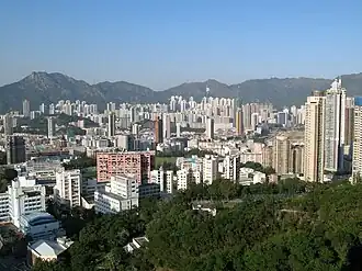
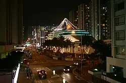
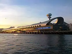
Aerial view of Kowloon City Kowloon Walled City Park Sung Wong Toi Whampoa Garden Kai Tak Cruise Terminal | |
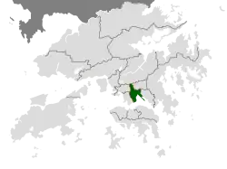 Location of Kowloon City District within Hong Kong | |
| Coordinates: 22°19′42″N 114°11′30″E / 22.32820°N 114.19155°E | |
| Country | China |
| SAR | Hong Kong |
| Constituencies | 25 |
| Government | |
| • District Officer | Tso Man Kwan[1] |
| • District Council Chairman | Ho Hin-ming |
| • District Council Vice-Chairman | Ng Po-Keung |
| Area | |
• Total | 9.97 km2 (3.85 sq mi) |
| Population (2016[2]) | |
• Total | 418,732 |
| • Density | 42,000/km2 (110,000/sq mi) |
| Time zone | UTC+8 (Hong Kong Time) |
| Largest neighbourhood by population | Ma Tau Kok (53,800 – 2016 est)[3] |
| Website | Kowloon City District Council |
| Kowloon City District | |||||||||||||||||||
|---|---|---|---|---|---|---|---|---|---|---|---|---|---|---|---|---|---|---|---|
| Traditional Chinese | 九龍城區 | ||||||||||||||||||
| Simplified Chinese | 九龙城区 | ||||||||||||||||||
| Jyutping | Gau2lung4 sing4 keoi1 | ||||||||||||||||||
| |||||||||||||||||||
Kowloon City District is one of the 18 districts of Hong Kong. It is located in the city of Kowloon and cut through by Boundary Street. It had a population of 381,352 in 2001, and increased to 418,732 in 2016.[4] The district has the third most educated residents while its residents enjoy the highest income in Kowloon. It borders all the other districts in Kowloon, with Kwun Tong district to the east, Wong Tai Sin district to its northeast, Sham Shui Po district to its northwest, and Yau Tsim Mong district to its southwest.
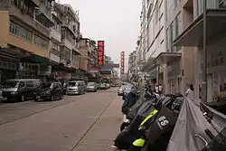
Kowloon City district covers about 1,000 hectares, and is mainly a residential area; most of its people live in private sector housing, including old tenement buildings, private residential developments and low-rise villas; the rest of them mainly live in public rental housing and the Home Ownership Scheme estates.[5] It is the only district that incorporated into the land of Hong Kong in different stages (Convention of Peking, Convention for the Extension of Hong Kong Territory and the demolition of the Kowloon Walled City)
The district includes many notable areas of Kowloon, such as Ho Man Tin, Hung Hom, Kai Tak Airport, Kowloon Tong, Ma Tau Wai, To Kwa Wan, and Whampoa Garden, and the proper Kowloon City, from where it derives its namesake.
History
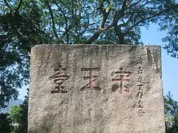
According to reliable historical records such as the History book of Song Dynasty (宋書), emperor Emperor Duanzong (Zhao Shi) and emperor Zhao Bing took refuge in nowadays Kowloon City District. Sung Wong Toi was a remarkable monument during that era.
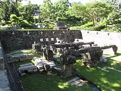
Part of the district was the location of the original Kowloon Walled City, see Kowloon Walled City. This is now Walled City Park.
The former airport, Kai Tak International Airport was also located in the district; part of it will be re-developed to be Kai Tak Cruise Terminal. In 1982, the Hong Kong Government decided to divide Hong Kong into 18 administrative districts, and Kowloon City and its neighbouring areas such as Hung Hom now belongs to Kowloon City District.
Areas
- Ho Man Tin
- Hung Hom
- Kadoorie Hill
- Kai Tak
- Kowloon City
- Kowloon Tong
- To Kwa Wan
- Whampoa
Sights
- Kowloon Walled City Park
- Sung Wong Toi Park
- Holy Trinity Cathedral
Education
- Universities
- Hong Kong Baptist University (Kowloon Tong main campus)
- Hong Kong Metropolitan University (Ho Man Tin main campus)
- The Hong Kong Polytechnic University (Hung Hom main campus)
See also
- List of places in Hong Kong
References
- ^ Welcome Message from Miss Alice CHOI, JP, District Officer (Kowloon City) Retrieved 2024-10-21
- ^ "2016 Population Census: Summary Results" (in English and Chinese). Census and Statistics Department, Hong Kong Government. 2017. Archived from the original on 8 October 2018. Retrieved 24 May 2018.
- ^ District Profiles, Hong Kong Government, 8 December 2017, archived from the original on 23 June 2020, retrieved 15 April 2020
- ^ "2016 HK Population by-Census Table A201a Population by District Council District and Year, Retrieved 2018-05-24". Archived from the original on 8 October 2018. Retrieved 24 May 2018.
- ^ Kowloon City district highlights extracted from Council website, Retrieved 2018-05-24
External links
Places adjacent to Kowloon City District | |
|---|---|
| |
| Hong Kong Island | |
| Kowloon and New Kowloon | |
| New Territories (excluding New Kowloon) | |
Urban areas of Hong Kong, Kowloon and New Territories | |||||||||||
|---|---|---|---|---|---|---|---|---|---|---|---|
| MHong Kong1,3,4,5,6,7,8,9a,10,11,12,14,15,16 |
|  | |||||||||
| MOld KowloonKL,1,2,3,4,5,6,7,8,9a,10,11,12,14,15,16 |
| ||||||||||
| MNew KowloonNKL,2,3,4,5,6,7,9a,10,11,12,14,15,16 |
| ||||||||||
| New Territories |
| ||||||||||
Official place names are summarized from "Geoinfo Map" of Government of Hong Kong Special Administrative Region, "Hong Kong Guide" of Lands Department, "Hong Kong Guide Book" of Universal Publications Ltd. and "Areas and Districts" of Rating and Valuation Department. M:Narrow meaning of urban areas KL: Kowloon Peninsula at the south of Boundary Street NKL: Former New Territories area at the north of Boundary Street and at the south of Lion Rock 1: Common definition (1) 2: Common definition (2) 3: Common definition (3) 4: Areas not adopting small house concessionary right of indigenous inhabitants 5: Jurisdiction area of former Urban Council 6: Definition of "Metropolitan Area" of Planning Department 7: Jurisdiction area of Urban Renewal Authority 8: Unique operating area of urban taxis 9: "Urban" (9a) and "Extended Urban" (9b) areas defined by Hong Kong Housing Authority 10: Definition of Urban rates 11: Hospital cluster belongs to Hong Kong or Kowloon 12: Police region belongs to Hong Kong or Kowloon 13: Regions having 999-year land lease 14: Geographical Constituency in Hong Kong Legislative Council belongs to Hong Kong or Kowloon 15: Regional Education Office belongs to Hong Kong or Kowloon 16: Primary One Admission School Net belongs to Hong Kong or Kowloon | |||||||||||