Wong Tai Sin District
Wong Tai Sin
黃大仙區 | |
|---|---|
| Wong Tai Sin District | |
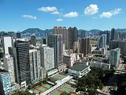 Day view of San Po Kong in the Wong Tai Sin District | |
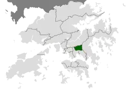 Location of Wong Tai Sin within Hong Kong | |
| Coordinates: 22°20′01″N 114°11′49″E / 22.33353°N 114.19686°E | |
| Country | China |
| SAR | Hong Kong |
| Constituencies | 25 |
| Government | |
| • District Council Chairman | vacant |
| • District Council Vice-Chairman | vacant |
| • District Officer | William Shiu |
| Area | |
• Total | 9.36 km2 (3.61 sq mi) |
| Population (2011[2]) | |
• Total | 420,183 |
| • Density | 45,000/km2 (120,000/sq mi) |
| Time zone | UTC+8 (Hong Kong Time) |
| Largest neighbourhood by population | Tsz Wan Shan (80,935 – 2016 est)[3] |
| Location of district office and district council | 138 Lung Cheung Road, Wong Tai Sin |
| Website | Wong Tai Sin District Council |
| Wong Tai Sin District | |||||||||||||||
|---|---|---|---|---|---|---|---|---|---|---|---|---|---|---|---|
| Traditional Chinese | 黃大仙區 | ||||||||||||||
| Simplified Chinese | 黄大仙区 | ||||||||||||||
| Cantonese Yale | Wòhng daaih sīn kēui | ||||||||||||||
| Literal meaning | big yellow immortal district | ||||||||||||||
| |||||||||||||||
Wong Tai Sin District is one of the 18 districts of Hong Kong. It is the only landlocked district in Hong Kong. It is located in Kowloon, and is the northernmost district in Kowloon. It borders the districts of Kwun Tong to its southeast, Kowloon City to its southwest, Sai Kung to its east, and Sha Tin to its north.
Geography
The district contains the areas of Diamond Hill, Wang Tau Hom, Lok Fu, Chuk Yuen, Wong Tai Sin, Tsz Wan Shan, Fung Wong, Ngau Chi Wan, Choi Hung and Choi Wan, an area that includes several major public housing estates.
Demographics
Wong Tai Sin District has a population of 444,630 (2001 figures). The district has the least educated residents with the lowest income, the oldest residents and the second highest population density. Over 85% of the district's residents live in public housing.
Religion
The district derives its name from the Wong Tai Sin Temple, dedicated to Wong Tai Sin, which is located there. The district is also the location of the Chi Lin Nunnery, built in the Tang dynasty style, a popular tourist attraction.
Education
Schools in Wong Tai Sin District include:
- Our Lady's Primary School (聖母小學), established in 1953
- Wong Tai Sin Catholic Primary School (黃大仙天主教小學), established in 1962.
- Bishop Walsh Primary School (華德學校), established in 1963.
- Baptist Rainbow Primary School (浸信會天虹小學), established in 1984.
Transport
Wong Tai Sin is served by Lung Cheung Road and the Kwun Tong line of the MTR metro system. The stations are Lok Fu, Wong Tai Sin, Diamond Hill and Choi Hung. Diamond Hill is also a station of Tuen Ma line. The old airport was located just south of this district.
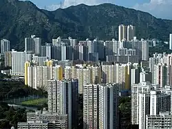
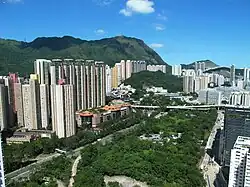
Gallery
 |
 |
See also
- List of places in Hong Kong
Notes
References
- ^ Eunice Mei Feng Seng (2020). Resistant City: Histories, Maps and the Architecture of Development. doi:10.1142/11394. ISBN 9789811211706. OCLC 1195954303.
- ^ "2011 Population Census: Summary Results" (in English and Chinese). Census and Statistics Department, Hong Kong Government. 2011. Retrieved 11 June 2012.
- ^ Summary of Provisional Recommendations for Wong Tai Sin District (PDF), Hong Kong Government, July 2019, retrieved 15 April 2020
External links
- Wong Tai Sin District Council
- District Council Election 2007 - Electoral Boundary Maps - Wong Tai Sin (6.7MB pdf file)
- Wong Tai Sin 黃大仙 Articles on, and photos and videos of, the district and places accessible from Wong Tai Sin station.
Places adjacent to Wong Tai Sin District | ||||||||||||||||
|---|---|---|---|---|---|---|---|---|---|---|---|---|---|---|---|---|
| ||||||||||||||||
| |
| Hong Kong Island | |
| Kowloon and New Kowloon | |
| New Territories (excluding New Kowloon) | |
Urban areas of Hong Kong, Kowloon and New Territories | |||||||||||
|---|---|---|---|---|---|---|---|---|---|---|---|
| MHong Kong1,3,4,5,6,7,8,9a,10,11,12,14,15,16 |
|  | |||||||||
| MOld KowloonKL,1,2,3,4,5,6,7,8,9a,10,11,12,14,15,16 |
| ||||||||||
| MNew KowloonNKL,2,3,4,5,6,7,9a,10,11,12,14,15,16 |
| ||||||||||
| New Territories |
| ||||||||||
Official place names are summarized from "Geoinfo Map" of Government of Hong Kong Special Administrative Region, "Hong Kong Guide" of Lands Department, "Hong Kong Guide Book" of Universal Publications Ltd. and "Areas and Districts" of Rating and Valuation Department. M:Narrow meaning of urban areas KL: Kowloon Peninsula at the south of Boundary Street NKL: Former New Territories area at the north of Boundary Street and at the south of Lion Rock 1: Common definition (1) 2: Common definition (2) 3: Common definition (3) 4: Areas not adopting small house concessionary right of indigenous inhabitants 5: Jurisdiction area of former Urban Council 6: Definition of "Metropolitan Area" of Planning Department 7: Jurisdiction area of Urban Renewal Authority 8: Unique operating area of urban taxis 9: "Urban" (9a) and "Extended Urban" (9b) areas defined by Hong Kong Housing Authority 10: Definition of Urban rates 11: Hospital cluster belongs to Hong Kong or Kowloon 12: Police region belongs to Hong Kong or Kowloon 13: Regions having 999-year land lease 14: Geographical Constituency in Hong Kong Legislative Council belongs to Hong Kong or Kowloon 15: Regional Education Office belongs to Hong Kong or Kowloon 16: Primary One Admission School Net belongs to Hong Kong or Kowloon | |||||||||||