Po Lam
| Po Lam | |||||||||||||||
|---|---|---|---|---|---|---|---|---|---|---|---|---|---|---|---|
| Traditional Chinese | 寶琳/寶林 | ||||||||||||||
| Simplified Chinese | 宝琳/宝林 | ||||||||||||||
| |||||||||||||||
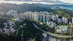
Po Lam (Chinese: 寶琳 or 寶林) is a neighbourhood in northern Tseung Kwan O, Kowloon. An MTR station with the same name, Tseung Kwan O Village, Yau Yue Wan Village, King Lam Estate, and Po Lam Estate are located there.
Name
Po Lam is named after one of the first roads in Tseung Kwan O, the Po Lam Road, whose name was taken from the Chinese translation of the first name of Barbara B. Whitener (寶琳), Rev. Sterling H. Whitener's wife. Rev. Whitener was a missionary based at the Haven of Hope Tuberculosis Sanatorium (now Haven of Hope Hospital) at the time.[1][2] When Po Lam Estate was under planning, it was named "寶林邨", with a different second character but pronounced in the same way. The Po Lam MTR station, on the contrary, used "琳". Government documents have used both names, referring to the area as "寶琳" in a brochure issued by the Planning Department,[3] but also using "林" for the Po Lam Sports Centre within Po Lam Estate.[4] Residents generally use both name interchangeably.
History
Same as Hang Hau, Po Lam was developed as part of the first phase of the Tseung Kwan O New Town.[5] Its first population intake came in 1988 with the opening of Po Lam Estate.[6] Before 2002, there was no railway access to or from Po Lam. The Tseung Kwan O line, including Po Lam station, opened in August 2002.[7]
In addition to the new town area, two villages, Tseung Kwan O Village and Yau Yue Wan Village, are also considered part of Po Lam, although their histories date back to long before the Tseung Kwan O New Town was conceived.
Demographics
Po Lam is designated Tertiary Planning Units 836 in the 2016 Population By-census. It is home to 88,272 people, where major ethnic groups are Chinese (95.2%), Indonesians (2.3%) and Filipino (1.5%). Most households live in subsidised home ownership housing (such as Home Ownership Scheme and Sandwich Class Housing Scheme projects) and private housing.[8]
Housing
Public housing
- Po Lam Estate (寶林邨). The second character ("林", Lam) is different from the one in the neighbourhood's name
- King Lam Estate
Home Ownership Scheme housing
- Yan Ming Court
- Ying Ming Court
- Ho Ming Court
Others
- The Pinnacle (developed by the Hong Kong Housing Society under the Sandwich Class Housing Scheme)
- Radiant Towers (developed by the Hong Kong Housing Society under the Sandwich Class Housing Scheme)
- Verbena Heights (developed by the Hong Kong Housing Society under the Flat-for-Sale Scheme)
Private housing
- Well On Garden
- Finery Park
- Serenity Place
- Metro City Phases 1 to 3
Education
Schools in Po Lam include:[9]
Primary schools
- King Lam Catholic Primary School (subsidised)
- Lok Sin Tong Lau Tak Primary School (subsidised)
- Shun Tak Fraternal Association Leung Kit Wah Primary School (subsidised)
- Po Leung Kuk Luk Hing Too Primary School (Direct Subsidy Scheme)
- Sheng Kung Hui Tseung Kwan O Kei Tak Primary School (subsidised)
- Tung Wah Group of Hospitals Wong Yee Jar Jat Memorial Primary School (subsidised)
Secondary schools
- Carmel Divine Grace Foundation Secondary School (subsidised)
- Ma Kam Ming Charitable Foundation Ma Chan Duen Hey Memorial College (subsidised)
- Shun Tak Fraternal Association Cheng Yu Tung Secondary School (subsidised)
- Tseung Kwan O Government Secondary School (government)
- Tung Wah Group of Hospitals Lui Yun Choy Memorial College (subsidised)
- Yan Chai Hospital Lan Chi Pat Memorial Secondary School (subsidised)
- Wellington Educational Organisation Chang Pui Chung Memorial School (subsidised)
- King Ling College (subsidised)
- Po Leung Kuk Laws Foundation College (Direct Subsidy Scheme)
Recreation
Po Lam hosts a number of public amenities, including the Tseung Kwan O Sports Centre, the Tseung Kwan O Public Swimming Pool and the Tseung Kwan O Public Library, all of which are located close to each other. Also in close proximity to the trio is Po Hong Park, where the annual Lunar New Year Fair takes place.[10] These facilities and the Po Tsui Park, situated next to Po Lam Estate, are all managed by the Leisure and Cultural Services Department.
The neighbourhood is also home to the Metro City Plaza, claimed to be the largest shopping complex in East Kowloon and which, same as the private housing development of which it is a part, comprises three phases: MCP One (formerly Metro City Plaza Phase 1), MCP Central (formerly Metro City Plaza Phase 2) and MCP Discovery (formerly Metro City Plaza Phase 3).[11]
Transport
Po Lam Road North and Po Hong Road are two major roadways in the neighbourhood, with most of the developments sandwiched between them. Po Lam Road North is the extension of Po Lam Road, where the area of Po Lam got its name. Po Lam Road opened in 1956 to connect the Haven of Hope Tuberculosis Sanatorium (now Haven of Hope Hospital) to Tiu Keng Leng and Ma Yau Tong.[12] During the Tseung Kwan O New Town development, Po Lam Road was extended eastward, into the new town, and westward, to Sau Mau Ping. The extension within the new town, which starts from Mau Wu Tsai Village and leads into Po Lam, was named Po Lam Road North. The other extension was still called Po Lam Road. The old section from Tiu Keng Leng to Ma Yau Tong was renamed to Po Lam Road South.
Public transportation in Po Lam is served by the MTRC, Kowloon Motor Bus (KMB) (NWFB) and Citybus. Citybus operates cross-harbour routes to Central (690) and Siu Sai Wan (694). Citybus also operates routes to Hong Kong International Airport Tung Chung, and Shatin. KMB runs routes to Mei Foo, Tsim Sha Tsui East, Mong Kok and Tsuen Wan, among others. The MTRC only runs Tseung Kwan O line, on which Po Lam MTR station is the only rail and subway station in the neighbourhood. In the Railway Development Strategy 2014, the government proposed the East Kowloon line will connect Po Lam station to Diamond Hill station. It is expected to open in 2025.[13]
Current District Councillors (2020-2023)
| Code | Constituency | Range[14] | Name | Political affiliation | Notes | |
|---|---|---|---|---|---|---|
| Q05 | Hang Hau West | Tseung Kwan O Village, Yau Yue Wan Village, Tai Po Tsai, Mau Wu Tsai Village and Ma Yau Tong | Yu Tsun-ning | TKO Shining | [a] | |
| Q16 | Hong King | Serenity Place, Hong Sing Garden and King Ming Court | Frankie Lam Siu-chung | Neo Democrats | [b][c] | |
| Q18 | Po Lam | Po Lam Estate | Fung Kwan-on | Neo Democrats | ||
| Q19 | Yan Ying | Metro City Phase 2, Yan Ming Court and Ying Ming Court | Ben Chung Kam-lun | Neo Democrats | [c] | |
| Q20 | Wai Yan | Finery Park, Radiant Towers, Verbena Heights and Well On Garden | Chun Hoi-shing | Neo Democrats | ||
| Q21 | Wan Hang | Metro City Phases 1 and 3 and The Pinnacle | Gary Fan Kwok-wai | Neo Democrats | [c] | |
| Q22 | King Lam | King Lam Estate and Ho Ming Court | Cheung Wai-chiu | TKO Pioneers | ||
Notes
References
- ^ 義章, 劉 (2015). 孤島扁舟:見證大時代的調景嶺 (in Chinese). Hong Kong: Joint Publishing. p. 87. ISBN 9789620438110.
- ^ "Whitener, Sterling Hegnauer". News & Record. 30 January 2017. Retrieved 20 March 2020.
- ^ "Tseung Kwan O" (PDF) (in Chinese). Retrieved 27 March 2020.
- ^ "Po Lam Sports Centre" (in Chinese). Leisure and Cultural Services Department. Retrieved 27 March 2020.
- ^ "政府規劃的發展" (in Chinese). Planning Department. Archived from the original on 28 March 2020. Retrieved 27 March 2020.
- ^ "E1 Tseung Kwan O New Town". Civil Engineering and Development Department. Retrieved 27 March 2020.
- ^ "Tseung Kwan O" (PDF). Planning Department. Retrieved 27 March 2020.
- ^ "2016 Population By-census". Census and Statistics Department. Retrieved 28 March 2020.
- ^ "Education Bureau School List by District - Sai Kung". Education Bureau. Archived from the original on 5 April 2020. Retrieved 5 April 2020.
- ^ "Auction of 2020 Lunar New Year Fairs Stalls". Food and Environmental Hygiene Department.
- ^ "Metro City Plaza". Metro City Plaza. Archived from the original on 5 April 2020. Retrieved 5 April 2020.
- ^ "西貢寶琳路落成 彭德主持開放禮". Kung Sheung Daily News. 7 November 1956.
- ^ Fung, Fanny; Siu, Phila (18 September 2014). "Surprise new MTR line planned for Kwun Tong". South China Morning Post. Retrieved 6 March 2020.
- ^ "Recommended District Council Constituency Areas" (PDF). Electoral Affairs Commission. Archived from the original (PDF) on 5 June 2019. Retrieved 7 April 2020.
Places adjacent to Po Lam | ||||||||||||||||
|---|---|---|---|---|---|---|---|---|---|---|---|---|---|---|---|---|
| ||||||||||||||||
| Areas |
| ||||
|---|---|---|---|---|---|
| Landmarks |
| ||||
| Education |
| ||||
| MTR stations |
| ||||
| Media |
| ||||
| Islands |
| ||||
| History |
| ||||
This list is incomplete. | |||||
Urban areas of Hong Kong, Kowloon and New Territories | |||||||||||
|---|---|---|---|---|---|---|---|---|---|---|---|
| MHong Kong1,3,4,5,6,7,8,9a,10,11,12,14,15,16 |
|  | |||||||||
| MOld KowloonKL,1,2,3,4,5,6,7,8,9a,10,11,12,14,15,16 |
| ||||||||||
| MNew KowloonNKL,2,3,4,5,6,7,9a,10,11,12,14,15,16 |
| ||||||||||
| New Territories |
| ||||||||||
Official place names are summarized from "Geoinfo Map" of Government of Hong Kong Special Administrative Region, "Hong Kong Guide" of Lands Department, "Hong Kong Guide Book" of Universal Publications Ltd. and "Areas and Districts" of Rating and Valuation Department. M:Narrow meaning of urban areas KL: Kowloon Peninsula at the south of Boundary Street NKL: Former New Territories area at the north of Boundary Street and at the south of Lion Rock 1: Common definition (1) 2: Common definition (2) 3: Common definition (3) 4: Areas not adopting small house concessionary right of indigenous inhabitants 5: Jurisdiction area of former Urban Council 6: Definition of "Metropolitan Area" of Planning Department 7: Jurisdiction area of Urban Renewal Authority 8: Unique operating area of urban taxis 9: "Urban" (9a) and "Extended Urban" (9b) areas defined by Hong Kong Housing Authority 10: Definition of Urban rates 11: Hospital cluster belongs to Hong Kong or Kowloon 12: Police region belongs to Hong Kong or Kowloon 13: Regions having 999-year land lease 14: Geographical Constituency in Hong Kong Legislative Council belongs to Hong Kong or Kowloon 15: Regional Education Office belongs to Hong Kong or Kowloon 16: Primary One Admission School Net belongs to Hong Kong or Kowloon | |||||||||||