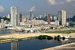
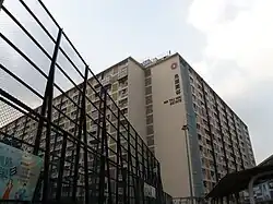
Ma Tau Kok (foreground) and Ma Tau Wai (background)Ma Tau Wai Estate
Ma Tau Wai
Traditional Chinese
馬頭圍
Simplified Chinese
马头围
Transcriptions
Standard Mandarin
Hanyu Pinyin
Mǎtóu Wéi
Yue: Cantonese
Jyutping
maa5 tau4 wai4
Ma Tau Wai (Chinese: 馬頭圍, originally 碼頭圍,[1] historically 古瑾圍) is an area in the Kowloon City District, Kowloon, Hong Kong.[2][3] It was originally a walled village (Cantonese: 圍; Wai) between present-day Argyle Street and Prince Edward Road West, east of present-day St. Teresa's Hospital.[4]
The area of Ma Tau Wai is not as well-defined as the original village, as the geographic features have been lost. The Ma Tau Wai Road in To Kwa Wan does not pass through Ma Tau Wai proper, although it was originally intended to. Ma Tau Wai is sometimes referred to the area south of Argyle Street and north of To Kwa Wan.
The public housing estate Ma Tau Wai Estate is named after the area / the original village.
Other landmark of the areas
Hong Kong's Notre Dame College is in Ma Tau Wai.
New Asia College, one of three founding colleges of the Chinese University of Hong Kong, was located near Tin Kwong Road (天光道) and Farm Road. After the college moved to Ma Liu Shui, Sha Tin, New Asia Middle School was founded at the former campus.
See also
Ma Tau Chung
Ma Tau Kok
References
^劉健宇 (21 January 2021). 馬頭圍得名竟然唔關「馬」事. Stand News (in Chinese (Hong Kong)). Retrieved 25 January 2021.
^2018香港大地圖 [Complete City Guide of Hong Kong 2018] (in Chinese (Hong Kong)). Wan Li Book.
^蕭險峰; 岑智明; 劉國偉 (15 April 2016). 九龍城「上帝古廟」原址考證(PDF). Fieldwork and Documents: South China Research Resource Station Newsletter (in Chinese (Hong Kong)) (83): 13. ISSN 1990-9020.
External links
Wikimedia Commons has media related to Ma Tau Wai.
Hang Hau8 (Except Hang Hau Station and A&E of Tseung Kwan O Hospital)
Tseung Kwan O8
Tiu Keng Leng8
Pak Shing Kok8 (Except Wan Po Road)
Siu Chik Sha8 (Except Wan Po Road and Shek Kok Road)
Tai Chik Sha8
Fat Tong O7,8
Fei Ngo Shan8,16
Tai Sheung Tok8,9a (Anderson8,9a)
Islands District11,14,15 (Tsing Chau Tsai Peninsula of Tsuen Wan District included)
Tung Chung New Town9b
Official place names are summarized from "Geoinfo Map" of Government of Hong Kong Special Administrative Region, "Hong Kong Guide" of Lands Department, "Hong Kong Guide Book" of Universal Publications Ltd. and "Areas and Districts" of Rating and Valuation Department. M:Narrow meaning of urban areas KL: Kowloon Peninsula at the south of Boundary Street NKL: Former New Territories area at the north of Boundary Street and at the south of Lion Rock 1: Common definition (1) 2: Common definition (2) 3: Common definition (3) 4: Areas not adopting small house concessionary right of indigenous inhabitants
5: Jurisdiction area of former Urban Council 6: Definition of "Metropolitan Area" of Planning Department 7: Jurisdiction area of Urban Renewal Authority 8: Unique operating area of urban taxis 9: "Urban" (9a) and "Extended Urban" (9b) areas defined by Hong Kong Housing Authority 10: Definition of Urban rates 11: Hospital cluster belongs to Hong Kong or Kowloon 12: Police region belongs to Hong Kong or Kowloon 13: Regions having 999-year land lease 14: Geographical Constituency in Hong Kong Legislative Council belongs to Hong Kong or Kowloon 15: Regional Education Office belongs to Hong Kong or Kowloon 16: Primary One Admission School Net belongs to Hong Kong or Kowloon