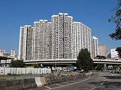
Yau Ma Tei
| Yau Ma Tei | |||||||||||||||||
|---|---|---|---|---|---|---|---|---|---|---|---|---|---|---|---|---|---|
 | |||||||||||||||||
| Chinese | 油麻地 | ||||||||||||||||
| Literal meaning | Oil-Jute Ground | ||||||||||||||||
| |||||||||||||||||
| Alternative Chinese name | |||||||||||||||||
| Chinese | 油蔴地 | ||||||||||||||||
| |||||||||||||||||
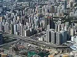
Yau Ma Tei is an area in the Yau Tsim Mong District in the south of the Kowloon Peninsula in Hong Kong.
Name
Yau Ma Tei is a phonetic transliteration of the name 油麻地 (originally written as 油蔴地) in Cantonese. It can also be spelt as Yaumatei, Yau Ma Ti, Yaumati or Yau-ma-Tee.
Yau (油) literally means "oil", Ma (麻 or 蔴) can either refer to "sesame" or "jute", and Tei (地) means "field" or "open ground". Hence, Yau Ma Tei can be interpreted to mean either "oil-sesame field" or "oil and jute ground". This dual-interpretation is perhaps the reason for there being two explanations for the origin of the place name.[1]
Geography
Dundas Street marks the north border of Yau Ma Tei with Mong Kok and Austin Road its south border with Jordan and Tsim Sha Tsui. To its west is Victoria Harbour and its east the hilly region of Ho Man Tin.
Southern Yau Ma Tei was traditionally known as Kwun Chung, but came to be called Jordan after the completion of Jordan MTR station at its heart.
History
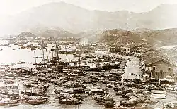
Yau Ma Tei was a village in Kowloon. It was mentioned that a Chinese burial ground was assigned at a mile northeast of a village of Yau-ma-Tee at 2 December 1871.[2] The name Yau Ma Tei is not thought to pre-date British rule. However, Kwun Chung is mentioned in many historic documents. Kwun Chung was a river valley with village and cultivation. To the south, a hill near the coast was used as a fortification by the military of the Qing dynasty during the 19th century. In 1839, Qing official Lin Zexu ordered the construction of a fortification in the area to defend against possible British attacks. When the First Opium War broke out, the fortification, along with another fort in Tsim Sha Tsui, saw action against British forces during the Battle of Kowloon.
Before the ceding of Kowloon to the British in 1860, Yau Ma Tei was a beach and a bay gathering many Tanka fishermen. Its water remains a harbour for fishermen after several times of reclamation by the Hong Kong Government. The Yau Ma Tei Typhoon Shelter became an exotic water area where restaurants on boats offered dishes of indigenous seafood. These 'typhoon shelter dishes' remain famous to this day and are even offered on land. The typhoon shelter not only hosted fishermen, but was also a port in Hong Kong. Numerous piers were built along its shore. Ferry Point in the southern part of Yau Ma Tei was a transportation hub where many commuters took ferries to and from Hong Kong Island. The service was offered by Hongkong and Yaumati Ferry.
Inland, the reclamation became the residential area for the ever-increasing Chinese population, with retail shops on the street level. Shanghai Street was the main street before being replaced by Nathan Road. Along Waterloo Road is the century-old Fruit Market; its adjacent Yaumati Theatre was once the largest in Kowloon. The Kwong Wah Hospital was the first hospital on the Kowloon peninsula, established in 1911. YMCA headquarters and its hostel in Hong Kong are located on the road. On 26 January 2021, 12 buildings in Yau Ma Tei were placed under lockdown due to COVID-19.[3]
Public health
Kwong Wah Hospital, run by charity Tung Wah Group of Hospitals, is the first major hospital in the area. Historically, there was a small pox hospital (油蔴地痘局) at the hill northeast of Kwong Wah Hospital. Founded by Hong Kong Government, Queen Elizabeth Hospital is another major hospital in the area.
Yaumatei Maternal & Child Health Centre (油麻地母嬰健康院) is under Family Health Service, Department of Health.[4]
Sightseeing
The district is mainly an area of mixed residential and retail. During day time, the Yau Ma Tei wet market and fruit market are the markets to visit, buying souvenirs like dried noodles and some fruits. Every night there is a market selling many different kinds of products including clothes, decorations, VCD and toys in Temple Street, a street in the area where the famous Tin Hau Temple was built in 1876. The Temple is at Public Square Street. The square, known as Yung Shue Tau, was a night market. Jade Market and Jade Street, China's most revered green stone is in abundance here, with around 400[5] registered stall owners ready to pitch jade amulets, ornaments, necklaces and trinkets.
Museums
The Hong Kong International Hobby and Toy Museum (香港國際玩具博物館), located at No. 330 Shanghai Street, showcases models, toys and pop culture memorabilia from around the world. Exhibits include toy vehicles, dolls, action figures, cartoon characters, science fiction collectibles, model rockets, Japanese anime, classic toys.[6]
Tung Wah Group of Hospitals Museum in Kwong Wah Hospital details the history of Tung Wah Group of Hospitals and its relation with Hong Kong people, is also located in Yau Ma Tei.
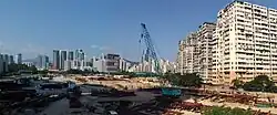
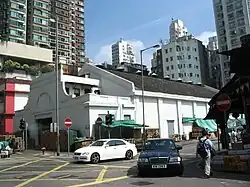
Historic buildings
.jpg)
.jpg)
- Tin Hau Temple (油麻地天后廟)
- Old Yau Ma Tei Police Station
- Yau Ma Tei Fruit Market
- Yau Ma Tei Theatre
- Engineer's Office of the Former Pumping Station (Red Brick Building)
- Former Kowloon Magistracy
- Kowloon Union Church
Public housing
Prosperous Garden
In the 1980s, the Government handed over the redevelopment project of Lee Tat Street (Chinese: 利達街) and Cheung Shui Street (Chinese: 祥瑞街) in Yau Mei Tei (the two streets were later removed during redevelopment) to the Hong Kong Housing Society. This became Prosperous Garden (Chinese: 駿發花園), an "Urban Improvement Scheme" estate[7] in Public Square Street[8] Phase 1, including Block 1, 2 and 5, was completed in the site in 1991. Block 1 and 2 were for sale while Block 5 was for rental. Its Phase 2, including Block 3 and 4, was completed in 1995 and was for sale.[9]
Hoi Fu Court
Hoi Fu Court (Chinese: 海富苑) is a mixed Home Ownership Scheme court and public estate built on reclaimed land of the old Yau Ma Tei Typhoon Shelter.[10][11] It is the only public housing estate built by Hong Kong Housing Authority in the District. It comprises 6 blocks completed in 1999 and 2004.[12][13]
Hoi Yu House of the estate was put under lockdown for mandatory COVID-19 testing on 7 February 2021.[14]
Hoi Fu Court is in Primary One Admission (POA) School Net 31.[15] Within the school net are multiple aided schools (operated independently but funded with government money) and Jordan Road Government Primary School.[16]
Charming Garden
Charming Garden is an 18-block estate built under the Home Ownership Scheme and Private Sector Participation Scheme.
Education
Primary and secondary schools
- Wah Yan College, Kowloon is a boys' school, located in 56 Waterloo Road in Yau Ma Tei.
- True Light Girls' College, a girls' EMI school, is adjacent to the above.
- The Methodist College is located in 50 Gascoigne Road in Yau Ma Tei. It is an EMI school for both boys and girls.
- Tung Koon Society Fong Shu Chuen School (東莞同鄉會方樹泉學校) is located near the Yau Ma Tei Fruit Market.
Yau Ma Tei is in Primary One Admission (POA) School Net 31. Within the school net are multiple aided schools (operated independently but funded with government money) and Jordan Road Government Primary School.[16]
Public Library

Hong Kong Public Libraries operates the Yau Ma Tei Public Library (油蔴地公共圖書館).
Transport
Nathan Road goes north–south across the heart of Yau Ma Tei. Most of buses routes via Nathan Road to the destinations in North Kowloon and New Territories. Trains of MTR shuttle beneath the road. Yau Ma Tei is served by Tsuen Wan and Kwun Tong lines on the MTR metro system, at a single station with the same name, Yau Ma Tei MTR station. Other streets in the area or partly in the area include:
- Canton Road
- Dundas Street - shares its Chinese name (登打士街) with the Chinatown section of Dundas Street and in Toronto and are both named for Henry Dundas, 1st Viscount Melville
- Portland Street
- Public Square Street
- Reclamation Street
- Shanghai Street
- Temple Street
See also
- List of places in Hong Kong
- Broadway Cinematheque
- Eaton Hotel Hong Kong
- Fo Pang
- King's Park, Hong Kong
- Kowloon Central Post Office
- Yau Ma Tei Car Park Building
- Yaumatei Ferry Pier
References
- ^ Architectural Conservation Office, HKSAR Government. (2008). Heritage Impact Assessment Report of the Yau Ma Tei Theatre & Red Brick Building Retrieved October 21, 2009
- ^ Hongkong Government Gazette, Notification 169 of 2 December 1871
- ^ Low, Zoe; Lam, Jeffie; Yeo, Rachel; Choy, Gigi (26 January 2021). "Hong Kong places residents of 12 buildings under sudden Covid-19 lockdown". South China Morning Post. Retrieved 26 January 2021.
- ^ "家庭健康服務 - 母嬰健康院". www.fhs.gov.hk (in Chinese (Hong Kong)). Retrieved 23 November 2018.
- ^ "Markets for Leisure and Pleasure | Hong Kong Tourism Board". www.discoverhongkong.com. Retrieved 23 November 2018.
- ^ "Official website of the Hong Kong International Hobby and Toy Museum". Archived from the original on 11 May 2016. Retrieved 1 December 2011.
- ^ "Urban Redevelopment Project (Chinese)". Archived from the original on 11 July 2021. Retrieved 2 September 2009.
- ^ "Location with Reverse Vending Machine Installed". Archived from the original on 22 June 2012. Retrieved 2 September 2009.
- ^ "Prosperous Garden (Chinese)". Archived from the original on 2 February 2020. Retrieved 2 September 2009.
- ^ TYPHOON SHELTER
- ^ Hoi Fu Shopping Centre, Mongkok
- ^ "Hoi Fu Court". Hong Kong Housing Authority. Archived from the original on 8 September 2011.
- ^ Yu, Pui-kwan, Robin, "A study on quasi-public space in large scale private residential development, case in Hong Kong", University of Hong Kong, 2007
- ^ RTHK
- ^ "POA2023 Primary School Lists by School Net for Discretionary Places Admission Stage". Education Bureau. Retrieved 13 October 2022.
- ^ a b "POA School Net 31" (PDF). Education Bureau. Archived from the original (PDF) on 12 September 2022. Retrieved 13 October 2022.
Further reading
- Hase, P. H., ed. (1999). In the Heart of the Metropolis: Yaumatei and its People. Joint Publishing. ISBN 9789620417474.
- Hayes, James (1966). "Old British Kowloon" (PDF). Journal of the Royal Asiatic Society Hong Kong Branch. 6: 120–137.
External links
- History of Yau Ma Tei (pp. 5–12)
- Dr. Lee Ho Yin 李浩然博士 (4 November 2015). "The Rise and Fall of Yau Ma Tei Theatre" (PDF). Education Bureau. Archived from the original (PDF) on 22 October 2020. Retrieved 28 August 2020.
Urban areas of Hong Kong, Kowloon and New Territories | |||||||||||
|---|---|---|---|---|---|---|---|---|---|---|---|
| MHong Kong1,3,4,5,6,7,8,9a,10,11,12,14,15,16 |
|  | |||||||||
| MOld KowloonKL,1,2,3,4,5,6,7,8,9a,10,11,12,14,15,16 |
| ||||||||||
| MNew KowloonNKL,2,3,4,5,6,7,9a,10,11,12,14,15,16 |
| ||||||||||
| New Territories |
| ||||||||||
Official place names are summarized from "Geoinfo Map" of Government of Hong Kong Special Administrative Region, "Hong Kong Guide" of Lands Department, "Hong Kong Guide Book" of Universal Publications Ltd. and "Areas and Districts" of Rating and Valuation Department. M:Narrow meaning of urban areas KL: Kowloon Peninsula at the south of Boundary Street NKL: Former New Territories area at the north of Boundary Street and at the south of Lion Rock 1: Common definition (1) 2: Common definition (2) 3: Common definition (3) 4: Areas not adopting small house concessionary right of indigenous inhabitants 5: Jurisdiction area of former Urban Council 6: Definition of "Metropolitan Area" of Planning Department 7: Jurisdiction area of Urban Renewal Authority 8: Unique operating area of urban taxis 9: "Urban" (9a) and "Extended Urban" (9b) areas defined by Hong Kong Housing Authority 10: Definition of Urban rates 11: Hospital cluster belongs to Hong Kong or Kowloon 12: Police region belongs to Hong Kong or Kowloon 13: Regions having 999-year land lease 14: Geographical Constituency in Hong Kong Legislative Council belongs to Hong Kong or Kowloon 15: Regional Education Office belongs to Hong Kong or Kowloon 16: Primary One Admission School Net belongs to Hong Kong or Kowloon | |||||||||||