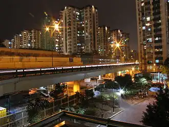
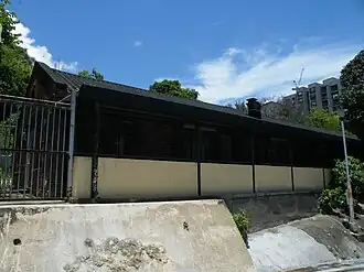
Mei Foo Sun Chuen housing estate in Lai Chi KokFormer Lai Chi Kok Hospital
Lai Chi Kok is a neighbourhood in Kowloon, Hong Kong, east of Kwai Chung and west of Cheung Sha Wan. Mei Foo Sun Chuen is the largest housing estate in the area and also the largest in Hong Kong with 99 blocks. Administratively, it belongs to Sham Shui Po District.[1][2]
History
Xin an county gazette (新安縣志), published in AD 1819, did not have any description of Lai chi kok, therefore, we did not have detail information of earlier history of the region.
Lai Chi Kok literally means "lychee corner", referring to a seashore named after a type of fruit tree native to southern China. However, some historians such as Leung Ping Wah suggested the original name of the region was Lai Tsai Kuok (孺仔脚), literally mean the footprint of the youngest son. The river once separated Cheung Sha Wan from Lai Chi Kok Bay, and a river from Butterfly Valley separated Cheung Sha Wan from Lai Chi Kok. At the innermost area of Lai Chi Kok Bay, namely present-day Lai King Hill Road, is a settlement called Kau Wa Keng.
The Qing government had set up a customs station in Lai Chi Kok, to collect customs duties after ceding Hong Kong Island and Kowloon Peninsula to the British.[3] After the lease of the New Territories, the British reclaimed Lai Chi Kok for military use. A torpedo storage facility was also erected on the west point of Lai Chi Kok Bay, an area near Kwai Chung.
At the time of the 1911 census, the population of Lai Chi Kok was 173.[4]
Buildings
Lai Chi Kok Hospital is a special hospital located on the original location of the cap. Its neighbour, the Lai Chi Kok Reception Centre, is managed by the Hong Kong Correctional Services. At one point, the Lai Chi Kok Incinerator was one of three incinerators in Hong Kong; however, it was demolished because it released pollutants into the Hong Kong air. The headquarters of the Kowloon Motor Bus was also in Lai Chi Kok, before being relocated; the site has since been replaced by a private housing project called Manhattan Hill.
Transport
The area is served by Mei Foo station on the MTR Tsuen Wan line and Tuen Ma line. The MTR's Lai Chi Kok station is actually in Cheung Sha Wan, not Lai Chi Kok. Mei Foo is a transportation hub due to its geographic location in the north-western end of Kowloon.[5] Lai Chi Kok Road is named after this place, but most part of the road lies outside Lai Chi Kok.
Education
Lai Chi Kok is in Primary One Admission (POA) School Net 40. Within the school net are multiple aided schools (operated independently but funded with government money) and two government schools: Fuk Wing Street Government Primary School and Li Cheng Uk Government Primary School.[6]
Hang Hau8 (Except Hang Hau Station and A&E of Tseung Kwan O Hospital)
Tseung Kwan O8
Tiu Keng Leng8
Pak Shing Kok8 (Except Wan Po Road)
Siu Chik Sha8 (Except Wan Po Road and Shek Kok Road)
Tai Chik Sha8
Fat Tong O7,8
Fei Ngo Shan8,16
Tai Sheung Tok8,9a (Anderson8,9a)
Islands District11,14,15 (Tsing Chau Tsai Peninsula of Tsuen Wan District included)
Tung Chung New Town9b
Official place names are summarized from "Geoinfo Map" of Government of Hong Kong Special Administrative Region, "Hong Kong Guide" of Lands Department, "Hong Kong Guide Book" of Universal Publications Ltd. and "Areas and Districts" of Rating and Valuation Department. M:Narrow meaning of urban areas KL: Kowloon Peninsula at the south of Boundary Street NKL: Former New Territories area at the north of Boundary Street and at the south of Lion Rock 1: Common definition (1) 2: Common definition (2) 3: Common definition (3) 4: Areas not adopting small house concessionary right of indigenous inhabitants
5: Jurisdiction area of former Urban Council 6: Definition of "Metropolitan Area" of Planning Department 7: Jurisdiction area of Urban Renewal Authority 8: Unique operating area of urban taxis 9: "Urban" (9a) and "Extended Urban" (9b) areas defined by Hong Kong Housing Authority 10: Definition of Urban rates 11: Hospital cluster belongs to Hong Kong or Kowloon 12: Police region belongs to Hong Kong or Kowloon 13: Regions having 999-year land lease 14: Geographical Constituency in Hong Kong Legislative Council belongs to Hong Kong or Kowloon 15: Regional Education Office belongs to Hong Kong or Kowloon 16: Primary One Admission School Net belongs to Hong Kong or Kowloon
Reclaimed land in Hong Kong, Kowloon and New Territories
Hong Kong
Sai Wan
Kennedy Town
Shek Tong Tsui
Sai Ying Pun
North of Victoria Road, Rock Hill Street, Belcher's Street and Des Voeux Road West
Sheung Wan Central Admiralty
North of Queen's Road West, Queen's Road Central and Queensway
West of Castle Peak Road - Castle Peak Bay, South of San Hui, East of Lung Mun Road near San Shek Wan
South of Lung Mun Road near Pillar Point and Tap Shek Kok
Nim Wan Road near Black Point Power Station, North of Tsang Tsui and Nim Wan
Tin Shui Wai New Town (Filling of ponds)
Tin Shui Wai
(All areas)
Sha Tin New Town
Sha Tin/Sha Tin Town Centre
Fo Tan
Sha Tin Tau
Sha Tin Wai
Yuen Chau Kok
Shek Mun
A Kung Kok
East of Lion Bridge, south of Tai Po Road Sha Tin Section and Lok King Street, north of Sha Kok Road and Sha Lek Highway, west of Tate's Cairn Highway and north of A Kung Kok Street
.JPG)